
The country of Brazil occupies roughly half of South America, bordering the Atlantic Ocean. Brazil covers a total area of 8,514,215 km2 (3,287,357 sq mi) which includes 8,456,510 km2 (3,265,080 sq mi) of land and 55,455 km2 (21,411 sq mi) of water. The highest point in Brazil is Pico da Neblina at 2,994 m (9,823 ft). Brazil is bordered by the countries of Argentina, Bolivia, Colombia, Guyana, Paraguay, Peru, Suriname, Uruguay, Venezuela, and French Guiana.

The Neotropical realm is one of the eight biogeographic realms constituting Earth's land surface. Physically, it includes the tropical terrestrial ecoregions of the Americas and the entire South American temperate zone.

The Amazon rainforest, also called Amazon jungle or Amazonia, is a moist broadleaf tropical rainforest in the Amazon biome that covers most of the Amazon basin of South America. This basin encompasses 7,000,000 km2 (2,700,000 sq mi), of which 6,000,000 km2 (2,300,000 sq mi) are covered by the rainforest. This region includes territory belonging to nine nations and 3,344 indigenous territories.

A grassland is an area where the vegetation is dominated by grasses (Poaceae). However, sedge (Cyperaceae) and rush (Juncaceae) can also be found along with variable proportions of legumes, like clover, and other herbs. Grasslands occur naturally on all continents except Antarctica and are found in most ecoregions of the Earth. Furthermore, grasslands are one of the largest biomes on Earth and dominate the landscape worldwide. There are different types of grasslands: natural grasslands, semi-natural grasslands, and agricultural grasslands. They cover 31–69% of the Earth's land area.
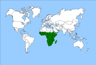
The Afrotropical realm is one of the Earth's eight biogeographic realms. It includes Sub-Saharan Africa, the southern Arabian Peninsula, the island of Madagascar, and the islands of the western Indian Ocean. It was formerly known as the Ethiopian Zone or Ethiopian Region.

Shifting cultivation is an agricultural system in which plots of land are cultivated temporarily, then abandoned while post-disturbance fallow vegetation is allowed to freely grow while the cultivator moves on to another plot. The period of cultivation is usually terminated when the soil shows signs of exhaustion or, more commonly, when the field is overrun by weeds. The period of time during which the field is cultivated is usually shorter than the period over which the land is allowed to regenerate by lying fallow.

Slash-and-burn agriculture is a farming method that involves the cutting and burning of plants in a forest or woodland to create a field called a swidden. The method begins by cutting down the trees and woody plants in an area. The downed vegetation, or "slash", is then left to dry, usually right before the rainiest part of the year. Then, the biomass is burned, resulting in a nutrient-rich layer of ash which makes the soil fertile, as well as temporarily eliminating weed and pest species. After about three to five years, the plot's productivity decreases due to depletion of nutrients along with weed and pest invasion, causing the farmers to abandon the field and move to a new area. The time it takes for a swidden to recover depends on the location and can be as little as five years to more than twenty years, after which the plot can be slashed and burned again, repeating the cycle. In Bangladesh and India, the practice is known as jhum or jhoom.

Bactris gasipaes is a species of palm native to the tropical forests of Central and South America. It is well spread in these regions, where it is often cultivated by smallholders in agroforestry systems or more rarely, in monoculture. Common names include peach palm in English, among others used in South American countries. It is a long-lived perennial plant that is productive for 50 to 75 years on average. Its population has an important genetic diversity, leading to numerous fruits, colors, and qualities. The fruits are edible and nutritious but need to be cooked for 30 minutes to five hours. They also benefit many animals in the wild. Peach-palms are also cultivated for the heart of palm, and the trunk can make valuable timber.

Terra preta, also known as Amazonian dark earth or Indian black earth, is a type of very dark, fertile anthropogenic soil (anthrosol) found in the Amazon Basin. In Portuguese its full name is terra preta do índio or terra preta de índio. Terra mulata is lighter or brownish in color.
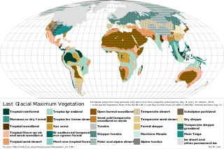
Last Glacial Maximum refugia were places (refugia) in which humans and other species survived during the Last Glacial Period, around 25,000 to 18,000 years ago. Glacial refugia are areas that climate changes were not as severe, and where species could recolonize after deglaciation.
The Guandera Biological Station is a biological station established in 1994 and situated in the northern inter-Andean valley of Ecuador. The station is managed by the Jatun Sacha Foundation and is located in Ecuador's Carchi Province..

The Llanos de Moxos, also known as the Beni savanna or Moxos plains, is a tropical savanna ecoregion of the Beni Department of northern Bolivia.
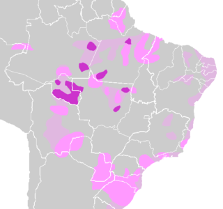
Amazonian languages is the term used to refer to the indigenous languages of "Greater Amazonia." This area is significantly larger than the Amazon and extends from the Atlantic coast all the way to the Andes, while its southern border is usually said to be the Paraná. The region is inhabited by societies that share many cultural traits but whose languages are characterized by great diversity. There are about 330 extant languages in Greater Amazonia, almost half of which have fewer than 500 speakers. Meanwhile, only Wayuu has greater than 100,000 speakers. Of the 330 total languages, about fifty are isolates, while the remaining ones belong to about 25 different families. Most of the posited families have few members. It is this distribution of many small and historically unrelated speech communities that makes Amazonia one of the most linguistically diverse regions in the world. The precise reasons for this unusual diversity have not yet been conclusively determined, but Amazonian languages seem to have had fewer than 10,000 native speakers even before the invasion of European colonists wrought havoc on the societies by which they were spoken. Despite the large-scale diversity, the long-term contact among many of the languages of Greater Amazonia has created similarities between many neighboring languages that are not genetically related. Most indigenous Amazonian people today are bilingual or even monolingual in English, Spanish, Portuguese, French or Dutch and many Amazonian languages are endangered as a result.
Indigenous horticulture is practised in various ways across all inhabited continents. Indigenous refers to the native peoples of a given area and horticulture is the practice of small-scale intercropping.
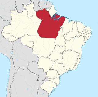
Caverna da Pedra Pintada, is an archaeological site in northern Brazil with evidence of human presence dating ca. 11,200 years ago.
A várzea forest is a seasonal floodplain forest inundated by whitewater rivers that occurs in the Amazon biome. Until the late 1970s, the definition was less clear and várzea was often used for all periodically flooded Amazonian forests.

Deforestation is a primary contributor to climate change, and climate change affects the health of forests. Land use change, especially in the form of deforestation, is the second largest source of carbon dioxide emissions from human activities, after the burning of fossil fuels. Greenhouse gases are emitted from deforestation during the burning of forest biomass and decomposition of remaining plant material and soil carbon. Global models and national greenhouse gas inventories give similar results for deforestation emissions. As of 2019, deforestation is responsible for about 11% of global greenhouse gas emissions. Carbon emissions from tropical deforestation are accelerating.

The Llanos de Moxos, also known as the Moxos plains, are extensive remains of pre-Columbian agricultural societies scattered over the Moxos plains in most of Beni Department, Bolivia. The remains testify to a well-organized and numerous indigenous people. This contradicts the traditional view of archaeologists, notably Betty Meggers, who asserted that the Amazon River Basin was not environmentally able to sustain a large population and that its indigenous inhabitants were hunter-gatherer bands or slash-and-burn farmers. In the 1960s, petroleum company geologists and geographer William Denevan were among the first to publicize the existence of extensive prehistoric earthworks constructed in the Amazon, especially in the Llanos de Moxos.

The Northern Andean páramo (NT1006) is an ecoregion containing páramo vegetation above the treeline in the Andes of Colombia and Ecuador. In the past, when the climate was cooler, the treeline and the páramo units were lower and the units were connected. During the present warmer Holocene epoch the páramos have migrated uphill, shrinking and becoming isolated. They contain many rare or endangered species, some of them restricted to a narrow area of one mountain or mountain range. The ecoregion is relatively well preserved, but faces threats from over-grazing and farming.
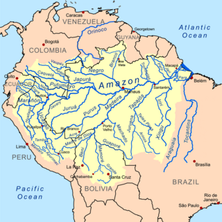
Pre-Columbian agriculture in the Amazon basin refers to the farming practices developed by the indigenous communities of the Amazon rainforest before the European conquest. Contrary to the common misconception of the pre-Columbian rainforest as a pristine wilderness untouched by human influence, agricultural communities in the Amazon Basin actively shaped and managed their environment prior to the arrival of European colonists. Eyewitness accounts by early Spanish and Portuguese explorers describe populous cities and flourishing agriculture. Population estimates for the pre-Columbian Amazon Basin range from a few million people to up to 10 million. After the population collapse following the European conquest, these communities were largely forgotten. Recent scientific research has helped to reconstruct the story of these lost settlements.


