
Franklin County is a county located in the U.S. state of Kentucky. As of the 2020 census, the population was 51,541. Its county seat is Frankfort, the state capital. The county was formed in 1795 from parts of Woodford, Mercer and Shelby counties, and was named after the American inventor and statesman Benjamin Franklin. Franklin County is part of the Frankfort, Kentucky Micropolitan Statistical Area. It shares a name with Franklin County in Ohio, where Columbus is located. This makes it one of two pairs of capital cities in counties of the same name, along with Marion Counties in Oregon and Indiana.

Fleming-Neon is a home rule-class city in Letcher County, Kentucky, in the United States. The population was 770 at the 2010 census, down from 840 at the 2000 census.

Jenkins is a home rule-class city in Letcher County, Kentucky, United States. The population was 2,203 as of the 2010 census.
Elkhorn City is a home rule-class city in Pike County, Kentucky, in the United States. The population was 982 at the 2010 census. The city is located in proximity to the Breaks Interstate Park.
Pikeville is a city in and the county seat of Pike County, Kentucky, United States. During the 2020 U.S. Census, the population within Pikeville's city limits was 7,754. In Kentucky's current city classification system, Pikeville is a home rule-class city, a category that includes all of the state's more than 400 cities except for the two largest, Louisville and Lexington.
Elkhorn or Elk Horn may refer to:
John Taylor (1752–1833) was a pioneer Baptist preacher, religious writer, frontier historian and planter in north and central Kentucky. His two histories of early Baptist churches in Kentucky provide insight into the frontier society of the early decades of the 19th century. His 1820 pamphlet entitled "Thoughts on Missions" put him at the center of the controversy within frontier Baptist congregations about supporting mission societies. In buying and selling land on the frontier, Taylor acquired 2,000 acres (8.1 km2) and 20 African-American slaves by the end of the first decade of the 19th century, thus entering the planter class.

The Kentucky River is a tributary of the Ohio River, 260 miles (418 km) long, in the U.S. Commonwealth of Kentucky. The river and its tributaries drain much of the central region of the state, with its upper course passing through the coal-mining regions of the Cumberland Mountains, and its lower course passing through the Bluegrass region in the north central part of the state. Its watershed encompasses about 7,000 square miles (18,000 km2). It supplies drinking water to about one-sixth of the population of the Commonwealth of Kentucky.

The Cumberland Mountains are a mountain range in the southeastern section of the Appalachian Mountains. They are located in western Virginia, southwestern West Virginia, the eastern edges of Kentucky, and eastern middle Tennessee, including the Crab Orchard Mountains. Their highest peak, with an elevation of 4,223 feet (1,287 m) above mean sea level, is High Knob, which is located near Norton, Virginia.

Elkhorn Creek is an 18.3-mile-long (29.5 km) stream running through several counties in central Kentucky in the United States. The stream drains an area of 499.5 square miles (1,294 km2). It derives its name from the shape, as seen on a map, of its main stem with its two primary forks.
David is an unincorporated community and coal town in Floyd County, Kentucky, United States along County Route 404. Located in the Appalachian Mountains, it lies approximately 100 miles (160 km) southeast of Lexington. The town was named for David L. Francis, president of Princess Elkhorn Coal Company which originally built and owned the town. It bears the postal ZIP code 41616. The U.S. Census of 2000 recorded a population of 435.

Breaks Interstate Park is a bi-state state park located partly in southeastern Kentucky and mostly in southwestern Virginia, in the Jefferson National Forest, at the northeastern terminus of Pine Mountain. Rather than their respective state park systems, it is instead administered by an interstate compact between the states of Virginia and Kentucky. It is one of several interstate parks in the United States, but only one of two operated jointly under a compact rather than as two separate state park units. The Virginia Department of Conservation and Recreation and the Kentucky Department of Parks are still major partner organizations, however.
The Kingsport Subdivision is a 133.2-mile railroad line owned and operated by CSX Transportation in the U.S. states of Kentucky, Virginia, and Tennessee. It was formerly part of the Huntington West Division. It became part of the CSX Florence Division on June 20, 2016. Running from Elkhorn City, Kentucky, south to Erwin, Tennessee, it forms the north half of the former Clinchfield Railroad; the south half, from Erwin to Spartanburg, South Carolina, is now the Blue Ridge Subdivision. From Elkhorn City, the line continues north as the Big Sandy Subdivision to Catlettsburg, Kentucky, on the Ohio River; trains can then continue to Ohio and other Midwest points. From Spartanburg, trains can continue to Georgia, Florida, or other Southeast states.

Pine Mountain is a ridge in the Appalachian Mountains running through Kentucky, Virginia and Tennessee. It extends about 125 miles from near Pioneer, Tennessee, to a location near Elkhorn City, Kentucky. Birch Knob, the highest point, is 3,273 feet (998 m) above sea level and is located on the Kentucky-Virginia border. It has long been a barrier to transportation, as the Cumberland River at Pineville, Kentucky is one of only two waterways that pass through the entire ridge. The other is the Clear Fork near Jellico, Tennessee.

Yuko-En on the Elkhorn, the official Kentucky-Japan Friendship Garden, is located in Georgetown, Kentucky on the north fork of Elkhorn Creek. The 6-acre (24,000 m2) garden is designed to have the appearance of a Japanese style strolling garden.
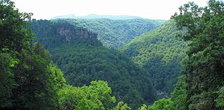
The Russell Fork is a 51.9-mile-long (83.5 km) tributary of the Levisa Fork in southwestern Virginia and southeastern Kentucky in the United States. Known for its whitewater, it rises in the Appalachian Mountains of southwest Virginia, in southern Buchanan County at the base of Big A Mountain, and flows northwest into Dickenson County. The Russell Fork continues to flow through the town of Haysi, Virginia, the Breaks Interstate Park, and the town of Elkhorn City, Kentucky, in Pike County, where it flows into the Levisa Fork which, together with the Tug Fork, form the Big Sandy River.
The history of the Baptist movement in the United States state of Kentucky begins around 1775, when a few Baptist preachers visited from Virginia. Virginians John Taylor, Joseph Reading, and Lewis Lunsford all visited in 1779, but returned to Virginia. Baptists began to settle around 1781, the first Baptist congregation of 18 people being left by John Garrard. Rev. Lewis Craig led several hundred people of "The Travelling Church", including several preachers, to Gilbert's Creek from Spotsylvania County, Virginia, arriving the first week of December 1781. Cedar Fork Church was founded in 1782.
Hi Hat is an unincorporated community and coal town located in Floyd County, Kentucky, United States. Their post office is still open.
Elkhorn Creek or Elk Horn Creek may refer to:


