Related Research Articles

James Ross Island is a large island off the southeast side and near the northeastern extremity of the Antarctic Peninsula, from which it is separated by Prince Gustav Channel. Rising to 1,630 metres (5,350 ft), it is irregularly shaped and extends 64 km in a north–south direction. It was charted in October 1903 by the Swedish Antarctic Expedition under Otto Nordenskiöld, who named it for Sir James Clark Ross, the leader of a British expedition to this area in 1842 that discovered and roughly charted a number of points along the eastern side of the island. The style, "James" Ross Island is used to avoid confusion with the more widely known Ross Island in McMurdo Sound.

Trinity Island or Île de la Trinité or Isla Trinidad is an island 24 km (15 mi) long and 10 km (6 mi) wide in the northern part of the Palmer Archipelago, Antarctica. It lies 37 km (23 mi) east of Hoseason Island,72.6 km (45 mi) south of Deception Island in the South Shetland Islands, and 10.3 km (6 mi) north-northwest of Cape Andreas on the Antarctic Peninsula. The island was named by Otto Nordenskiöld, leader of the 1901-1904 Swedish Antarctic Expedition (SAE) in commemoration of Edward Bransfield's "Trinity Land" of 1820.
The Ford Ranges are a grouping of mountain ranges standing east of Sulzberger Ice Shelf and Block Bay in the northwest part of Marie Byrd Land, Antarctica. Discovered by the Byrd Antarctic Expedition on December 5, 1929, they were named by Byrd for Edsel Ford of the Ford Motor Company, who helped finance the expedition.
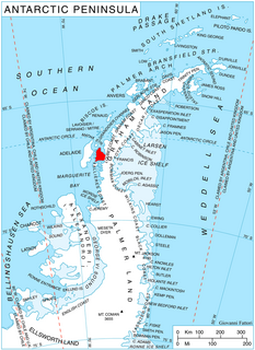
Cape Longing is a rocky cape on the east coast of Graham Land, Antarctica, forming the south end of a large ice-covered promontory which marks the west side of the south entrance to Prince Gustav Channel. It was discovered by the Swedish Antarctic Expedition under Otto Nordenskiöld in 1902, and so named by him because from the position of his winter hut on Snow Hill Island the cape lay in the direction of his "land of longing" which he was anxious to explore.

Laubeuf Fjord is a sound in Antarctica, 40 kilometres long in a north-south direction and averaging 16 km (10 mi) wide, lying between the east-central portion of Adelaide Island and the southern part of Arrowsmith Peninsula, Graham Land. It connects Hanusse Bay to the north with Marguerite Bay to the south. The southern 'border' between Laubeuf Fjord and Marguerite Bay is formed by the line between Rothera Point, Adelaide Island, and Cape Sáenz, which is the southernmost point of the Arrowsmith Peninsula. The fjord was discovered by the French Antarctic Expedition, 1908–10, under Jean-Baptiste Charcot, and named by him for Maxime Laubeuf, a French marine engineer who supervised building the engine for the ship Pourquoi-Pas.
Arrowsmith Peninsula is a cape about 40 miles (64 km) long on the west coast of Graham Land, west of Forel Glacier, Sharp Glacier and Lallemand Fjord, and northwest of Bourgeois Fjord, with Hanusse Bay lying to the northwest. It was surveyed by the Falkland Islands Dependencies Survey (FIDS) in 1955-58 and named for Edwin Porter Arrowsmith, Governor of the Falkland Islands.
Hanusse Bay is a broad, V-shaped bay, off the west coast of Graham Land, Antarctica. The bay is 37 kilometres (20 nmi) long and trends generally north-south. It is bordered by Cape Mascart on Anvers Island, and Shmidt Point on Arrowsmith Peninsula, Loubet Coast. At its north entrance, Isacke Passage separates it from Liard Island. It is bounded to the south by a line from Landauer Point, the north point of Hansen Island and Bagnold Point on Arrowsmith Peninsula.

Larsen Harbour is a narrow 2.6 miles (4.2 km) long inlet of indenting volcanic rocks and sheeted dykes known as the Larsen Harbour Formation. It is a branch of Drygalski Fjord, entered 2.5 miles (4 km) west-northwest of Nattriss Head, at the southeast end of South Georgia Island. It was charted by the Second German Antarctic Expedition, 1911–12, under Filchner, who named it for Captain Carl Anton Larsen a Norwegian explorer, who made significant contributions to the exploration of Antarctica. The most significant of these was the first discovery of fossils on the continent, for which he received the Back Grant from the Royal Geographical Society. Larsen is also considered the founder of the Antarctic whaling industry and the settlement and whaling station of Grytviken, South Georgia.

Adams Glacier, also known as John Quincy Adams Glacier, is a broad channel glacier in Wilkes Land, Antarctica which is over 20 miles (32 km) long. It debouches into the head of Vincennes Bay, just east of Hatch Islands. It was first mapped in 1955 by G.D. Blodgett from aerial photographs taken by U.S. Navy Operation Highjump (1947), and it was named by the Advisory Committee on Antarctic Names (US-ACAN) for John Quincy Adams, sixth President of the United States. Adams was instrumental while later serving as U.S. representative from Massachusetts in gaining congressional authorization of the United States Exploring Expedition (1838–42) under Lieutenant Charles Wilkes, and perpetuating the compilation and publication of the large number of scientific reports based on the work of this expedition.
Schweitzer Glacier is a glacier which drains west along the north side of Littlewood Nunataks into Vahsel Bay. The Lerchenfeld Glacier, trending west-northwestward, coalesces with the lower portion of this glacier. Discovered by the German Antarctic Expedition, 1911–12, under Wilhelm Filchner. He named it for Major Schweitzer, first president of the German Antarctic Expedition Society.

Posadowsky Glacier is a glacier about 9 nautical miles long, flowing north to Posadowsky Bay immediately east of Gaussberg. Posadowsky Bay is an open embayment, located just east of the West Ice Shelf and fronting on the Davis Sea in Kaiser Wilhelm II Land. Kaiser Wilhelm II Land is the part of East Antarctica lying between Cape Penck, at 87°43'E, and Cape Filchner, at 91°54'E, and is claimed by Australia as part of the Australian Antarctic Territory. Other notable geographic features in this area include Drygalski Island, located 45 mi NNE of Cape Filchner in the Davis Sea, and Mirny Station, a Russian scientific research station.
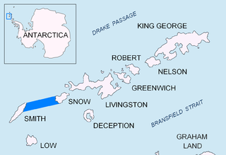
Boyd Strait is the 40-kilometre (25 mi) wide strait lying between Snow Island and Smith Island in the South Shetland Islands, Antarctica, and linking Drake Passage and the Bransfield Strait.
Apollo Glacier is a glacier, 9 nautical miles (17 km) long, flowing northeast and joining the lower part of Aphrodite Glacier 2 nautical miles (4 km) from the east coast of the Antarctic Peninsula.

Belgica Glacier is a glacier 8 nautical miles (15 km) long, flowing into Trooz Glacier to the east of Lancaster Hill on Kyiv Peninsula, on the west coast of Graham Land. It was first charted by the British Graham Land Expedition under John Rymill, 1934–37, and named by the UK Antarctic Place-Names Committee in 1959 after the RV Belgica, the ship of the Belgian Antarctic Expedition under Gerlache which explored this area in 1897–99.
Blümcke Knoll is a small steep-sided feature protruding through the ice of northern Adelaide Island, about 11 nautical miles (20 km) southwest of Mount Velain. It was mapped from air photos taken by the Ronne Antarctic Research Expedition (1947–48) and the Falkland Islands and Dependencies Aerial Survey Expedition (1956–57), and named by the UK Antarctic Place-Names Committee after Adolf Blümcke (1854–1914), a German glaciologist who was a professor in the Oberrealschule at Augsburg.
Dennison Reef is a reef between the Shull Rocks and the Pauling Islands, lying east of the south end of the Biscoe Islands in Crystal Sound. It was mapped from air photos obtained by the Ronne Antarctic Research Expedition (1947–48) and from surveys by the Falkland Islands Dependencies Survey (1958–59). It was named by the UK Antarctic Place-Names Committee for David M. Dennison, a physicist who took x-ray diffraction pictures which were used to interpret the crystal structure of ice.
Mount Paris is a conspicuous mountain, about 2,800 m, 4 nautical miles (7 km) southeast of Mount Bayonne situated in the northern portion of Alexander Island, Antarctica. The mountain was first mapped by the French Antarctic Expedition, 1908–10, under Charcot, who named it for the French capital, Paris. The mountain was resighted in 1936 by the British Graham Land Expedition (BGLE) and charted as mountains, but subsequent study of air photos taken by the Ronne Antarctic Research Expedition (RARE), 1947–48, has caused the name to be restricted to this single mountain. Mount Paris is the third-highest peak of Alexander Island, while Mount Egbert remains second standing at 2,850 m in height.

Gourdon Glacier is a glacier 4 nautical miles (7 km) long on the east side of James Ross Island, flowing southeast into Markham Bay between Saint Rita Point and Rabot Point. It has a conspicuous rock wall at its head. The glacier was first surveyed by the Swedish Antarctic Expedition under Otto Nordenskiöld, 1901–04, who named it for Ernest Gourdon, geologist and glaciologist of the French Antarctic Expedition, 1903–05.
Lystad Bay is a bay 2.5 nautical miles (5 km) wide which indents the west side of Horseshoe Island, in the northeast part of Marguerite Bay, Antarctica. It was first surveyed in 1936–37 by the British Graham Land Expedition under John Rymill, and was visited by the USMS North Star and USS Bear of the United States Antarctic Service in 1940. The name was proposed by the Advisory Committee on Antarctic Names for Captain Isak Lystad of the North Star.
References
- ↑ "Forsters Passage". Geographic Names Information System . United States Geological Survey . Retrieved 2012-04-02.
![]() This article incorporates public domain material from the United States Geological Survey document: "Forsters Passage".(content from the Geographic Names Information System )
This article incorporates public domain material from the United States Geological Survey document: "Forsters Passage".(content from the Geographic Names Information System )
| | This South Georgia and the South Sandwich Islands location article is a stub. You can help Wikipedia by expanding it. |