Fort Abercrombie

Last updated
Fort Abercrombie
FORT ABERCROMBIE.jpg
Fort Abercrombie in 2007
USA North Dakota location map.svg
Red pog.svg
Usa edcp location map.svg
Red pog.svg
Location Abercrombie, North Dakota
Coordinates 46°26′41″N96°43′7″W / 46.44472°N 96.71861°W / 46.44472; -96.71861
Built1860
ArchitectWPA
Architectural styleRustic/Log
NRHP reference No. 08001367 [1]
Added to NRHPJanuary 22, 2009

Fort Abercrombie, in North Dakota, was a United States Army fort established by authority of an Act of Congress, March 3, 1857. The act allocated twenty-five square miles of land on the Red River of the North in Dakota Territory to be used for a military outpost, but the exact location was left to the discretion of Lieutenant Colonel John J. Abercrombie. The fort was constructed in the year 1858. It was the first permanent military installation in what became North Dakota, and is thus known as "The Gateway to the Dakotas". Abercrombie selected a site right on the river. Spring flooding was a problem and the fort was abandoned. However, in 1860 the Army returned, moving the fort to higher ground.

Contents

History

Because the original location was prone to flooding, a new fort was built at a higher location in 1860, north of the original location. It was besieged by the Dakota (Sioux) Indians for more than six weeks during the Dakota War of 1862. The fort was abandoned in 1877 and the town of Abercrombie, North Dakota, was founded a half mile west in 1884. Abercrombie Township was settled, in part, due to the early presence of the fort. [2]

The fort served as a transportation hub as it guarded the Red River Trails used by the Red River ox cart trains of the late fur trade, military supply wagon trains, stagecoach routes, and steamboat traffic on the Red River. [3]

The original buildings were either destroyed or sold at public auction when the fort was abandoned, but a Works Progress Administration project in 1939–1940 reconstructed three blockhouses and the stockade and returned the original military guardhouse to the site. More recent renovations include dismantling the southeast blockhouse and using salvageable materials to renovate the two remaining blockhouses and the guardhouse.

A new stockade was constructed and native grasses are allowed to grow in the locations of the missing buildings for visitors to get an idea about the size and shape of the buildings. A visitor's center was built in the summer of 2007. Today it is known as Fort Abercrombie State Historic Site and includes a modern museum and pavilion in the town of Abercrombie. The fort itself is a quarter mile east.

Dakota War of 1862

During the 1862 hostilities the Sioux attacked Fort Abercrombie, Fort Ridgely, New Ulm, Lower Sioux Indian Agency, and all of the white settlements bordering the Minnesota River. The hostiles were divided between two main attacking forces. The first constituted the larger lower agency force of Mdewakaton, Wahpute, Yankton, and Winnebago warriors. They fought at Fort Ridgely, New Ulm, Redwood Ferry, and Birch Coulee. [4] The smaller upper agency force of Sisseton attacked the Ottertail Land Office, the nearby Pillager Chippewa village on Pine lake, Breckinridge, Grahams Crossing and Fort Abercrombie.

At the outbreak of the uprising, Fort Abercrombie was garrisoned by Company D of the 5th Minnesota Infantry Regiment, commanded by Captain John Vander Horck. [5] On 23 August the fort was preparing to escort the Chipppewa treaty provisions when word came of the uprising on the lower Sioux Reservation. [6] On August 25, 1862, Van der Horck mustered a militia company from the settlers seeking the security of the fort. Captain T. D. Smith, fort quartermaster, was appointed their commander [7]

In August 1862 the fort was tested. Pierre Bottineau and Indian Commissioner Dole were at Abercrombie in advance of the upcoming Chippewa treaty. [8] Increased Indian activity caused nearby settlers to seek safety at the fort's stockade. The Sioux besieged Fort Abercrombie for almost six weeks, alternating between occasional skirmishing and all-out attacks. The defenders, with rifles, shotguns, and howitzers held the fort. The shotguns came out of the Red Lake Chippewa treaty goods at the fort for safe keeping. The first incident was a raid in which the Sioux that took all of the cattle, horses and mules outside the fort. The number of animals was over 300 and included all the cattle intended as part of the treaty payment to the Red Lake and Pembina Chippewa. [9] The planned treaty meeting was interrupted by the ongoing hostilities. Fort Abercrombie was attacked three times. The first started at day break on September 3, 1862. [10] [8] It lasted six hours and was broken by the arrival of the Chippewa of G Company 9th Minn and Captain Ambrose Freeman's Company of Mounted Men, aka "Northern Rangers," from St. Cloud, Minnesota. [11] [12] Once darkness fell Bottineau slipped out of the fort, through the Sioux lines to travel 80 miles to Sauk Center for reinforcements. [8] The second attack came three days later killing and wounding a few defenders. Accounts of the second attack relate that the garrison was impressed by the obvious organization of the assault. [13] Howitzer fire from the garrison kept the fort from being lost. Afterwards the garrison constructed a defensive breastworks of soil and timbers around the untorched portion of the fort. Van der Horck, not having received any word or support from Fort Snelling, turned to the Chippewa at La Grand Fourche for support. After a long deliberation the Chiefs said no even though many of their men wanted to help according to a report by Pierre Bottineau who had returned. [14] Then followed an extended siege which was broke by the arrival of a 500 man militia force. [15] Later when the Red Lake Chiefs learned that the Sioux had cattle intended for them and were the reason the treaty commission never came they offered to defend the northern frontier. [16]

A soldiers letter later described the corpse of one of the defenders killed outside the fort. He was mutilated in the same manner reported of the Redwood ferryman at the Lower Agency. [17]

Also afterwards, fort defenders and civilians felt Capt. T. D. Smith was owed recognition for his leadership and saving their lives. [18] In one letter the fort commander Van der Hoeck was labeled a coward. [17] On his own volition, he transferred Abercrombie's command to a senior State militia commander. The troops and civilians blamed Van der Hoeck for the deaths of two men. Another letter describes one of the dead, (Joseph Comptois, G Co. 9th Minn), as "one of the bravest citizens, a soldier from the redskins"(a White Earth Chippewa). [17] :p.1 Capt. Smith had to intervene three times to save Van der Hoeck from being shot by his own men. [17]

G Co. 9th Minn remained posted to the garrison for over a year. Hatch's Battalion, aka the Minnesota Volunteer Indian Regiment, would relieve them and A Company 1st U.S. Vol. came in 1865. [19] They were ex-confederate pows mustered into federal service. The 8th Minn. also had a Company posted to the garrison from 1862 until May 1864 . [20]

The Chippewa treaty commission returned to the Red River Valley in 1863 for the Treaty of Old Crossing at Fisher's landing.

Casualties

Killed:

Wounded:


1870 Intertribal Treaty

On August 14, 1870 Sioux and Chippewa leaders signed a peace agreement at Fort Abercrombie instigated by the Catholic priest Father Genin. Intertribal hostilities had commenced again in 1868 with the deaths of two Sioux at the Leech lake Reservation. Chief Flatmouth II was accused of what happened on his Reservation. The 1870 treaty brought a successful end to the Intertribal issues that continues to the present. There were many names signed on that treaty.

Related Research Articles

<span class="mw-page-title-main">Fort Snelling</span> Historic fort in Minnesota, US

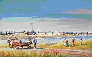
Fort Snelling is a former military fortification and National Historic Landmark in the U.S. state of Minnesota on the bluffs overlooking the confluence of the Minnesota and Mississippi Rivers. The military site was initially named Fort Saint Anthony, but it was renamed Fort Snelling once its construction was completed in 1825.

<span class="mw-page-title-main">Alexander Ramsey</span> American politician (1815–1903)

Alexander Ramsey was an American politician. He served as a Whig and Republican over a variety of offices between the 1840s and the 1880s. He was the first Minnesota Territorial Governor.

<span class="mw-page-title-main">Red Lake Indian Reservation</span> Home to the federally recognized Red Lake Band of Ojibwe

The Red Lake Indian Reservation covers 1,260.3 sq mi in parts of nine counties in Minnesota, United States. It is made up of numerous holdings but the largest section is an area about Red Lake, in north-central Minnesota, the largest lake in the state. This section lies primarily in the counties of Beltrami and Clearwater. Land in seven other counties is also part of the reservation. The reservation population was 5,506 in the 2020 census.

<span class="mw-page-title-main">Pipestone National Monument</span> United States historic place

Pipestone National Monument is located in southwestern Minnesota, just north of the city of Pipestone, Minnesota. It is located along the highways of U.S. Route 75, Minnesota State Highway 23 and Minnesota State Highway 30. The quarries are culturally significant to 23 tribal nations of North America. Those known to actually occupied the site chronologically are the Yankton Dakota, Iowa, and Omaha peoples. The Quarries were considered a neutral territory in the historic past where all tribal nations could quarry stone for ceremonial pipes. The catlinite, or "pipestone", is traditionally used to make ceremonial pipes. They are vitally important to Plains Indian traditional practices. Archeologists believe the site has been in use for over 3000 years with Minnesota pipestone having been found in ancient North American burial mounds across a large geographic area.

<span class="mw-page-title-main">Fort Ridgely</span> Frontier U.S. Army outpost in present-day Nicollet County, Minnesota (1851–67)

Fort Ridgely was a frontier United States Army outpost from 1851 to 1867, built 1853–1854 in Minnesota Territory. The Sioux called it Esa Tonka. It was located overlooking the Minnesota River southwest of Fairfax, Minnesota. Half of the fort's land was part of the south reservation in the Minnesota river valley for the Mdewakanton and Wahpekute tribes. Fort Ridgely had no defensive wall, palisade, or guard towers. The Army referred to the fort as the "New Post on the Upper Minnesota" until it was named for two Maryland Army Officers named Ridgely, who died during the Mexican–American War.

<span class="mw-page-title-main">White Earth Nation</span> Native American band in Minnesota, USA

The White Earth Band of the Minnesota Chippewa Tribe, also called the White Earth Nation, is a federally recognized Native American band located in northwestern Minnesota. The band's land base is the White Earth Indian Reservation.

<span class="mw-page-title-main">Mille Lacs Band of Ojibwe</span> Federally recognized American Indian tribe in east-central Minnesota

The Mille Lacs Band of Ojibwe, also known as the Mille Lacs Band of Chippewa Indians, is a federally recognized American Indian tribe in east-central Minnesota. The Band has 4,302 members as of 2012. Its homeland is the Mille Lacs Indian Reservation, consisting of District I, District II, District IIa, and District III.

Mississippi River Band of Chippewa Indians or simply the Mississippi Chippewa, are a historical Ojibwa Band inhabiting the headwaters of the Mississippi River and its tributaries in present-day Minnesota.

<span class="mw-page-title-main">1st Minnesota Cavalry Regiment</span> Military unit

The 1st Minnesota Cavalry Regiment, also known as the Mounted Rangers, was a Minnesota USV mounted infantry regiment that served in the Union Army during the American Civil War.

<span class="mw-page-title-main">Huot, Minnesota</span> Unincorporated community in Minnesota, United States

Huot is an unincorporated community in Louisville Township, Red Lake County, Minnesota, United States. The name of the community evokes the French-Canadian and Métis history of the Red River Trails and the Pembina settlements of Assiniboia.

<span class="mw-page-title-main">Hatch's Minnesota Cavalry Battalion</span> Military unit

Hatch's Minnesota Cavalry Battalion was a Minnesota USV cavalry battalion that served in the Union Army during the American Civil War and American Indian Wars.

<span class="mw-page-title-main">3rd Minnesota Light Artillery Battery</span> Military unit

The 3rd Minnesota Light Artillery Battery was a Minnesota USV artillery battery that served in the Union Army during the American Civil War and the American Indian Wars.

<span class="mw-page-title-main">Dakota War of 1862</span> Armed conflict between the United States and four bands of the eastern Dakota

The Dakota War of 1862, also known as the Sioux Uprising, the Dakota Uprising, the Sioux Outbreak of 1862, the Dakota Conflict, or Little Crow's War, was an armed conflict between the United States and several eastern bands of Dakota collectively known as the Santee Sioux. It began on August 18, 1862, when the Dakota, who were facing starvation and displacement, attacked white settlements at the Lower Sioux Agency along the Minnesota River valley in southwest Minnesota. The war lasted for five weeks and resulted in the deaths of hundreds of settlers and the displacement of thousands more. In the aftermath, the Dakota people were exiled from their homelands, forcibly sent to reservations in the Dakotas and Nebraska, and the State of Minnesota confiscated and sold all their remaining land in the state. The war also ended with the largest mass execution in United States history with the hanging of 38 Dakota men.

The 41st Iowa Infantry Battalion was an infantry battalion that served in the Union Army during the American Civil War.

<span class="mw-page-title-main">Slaughter Slough</span>

Slaughter Slough is a wetland in southwestern Minnesota, named for being the site of the Lake Shetek Massacre during the Dakota War of 1862. It is located in Murray County east of Lake Shetek. On August 20, 1862, about 40 Sisseton warriors led by Chiefs White Lodge and Lean Bear attacked the Euro-American settlers living nearby, killing 15 and taking 3 women and 8 children captive. 21 settlers escaped and made difficult treks across the prairie to safety.

<span class="mw-page-title-main">Treaty of Old Crossing</span>

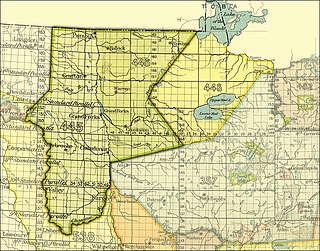
The Pembina and Red Lake bands of Chippewa ceded to the United States the Red River Valley of the north in two treaties. Both were named for the treaty site, "Old Crossing" and the year, Treaty of Old Crossing (1863) and the Treaty of Old Crossing (1864). In Minnesota, the ceded territory included all land west of a line running generally southwest from the Lake of the Woods to Thief Lake, about 30 miles (48 km) west of Red Lake, and then angling southeast to the headwaters of the Wild Rice River near the divide separating the watersheds of the Red River of the North and the Mississippi River. In North Dakota, the ceded territory was all of the Red River Valley north of the Sheyenne River. In size, the area was roughly 127 miles (204 km) east-west and 188 miles (303 km) north-south, making it nearly 11,000,000 acres (45,000 km2) of prairie and forest.

The Department of the Northwest was an U.S. Army Department created on September 6, 1862, to put down the Sioux uprising in Minnesota. Major General John Pope was made commander of the Department. At the end of the Civil War the Department was redesignated the Department of Dakota.

<span class="mw-page-title-main">David Cooper (jurist)</span> American judge

David Cooper was an American lawyer and jurist. He served from 1850 to 1853 as an associate justice of the Minnesota (Territory) Supreme Court.

<span class="mw-page-title-main">Hole in the Day</span> Chippewa chief (1825–1868)

Hole-in-the-Day was a prominent chief of the Mississippi band of Ojibwe/Chippewa/Anishinaabe in Minnesota. The native pronunciation has been written with different spellings due different speakers variance in their enunciation, such as Bagone-giizhig, Bagwunagijik, Bug-o-nay-ki-shig, Pugonakeshig or Puk-O-Nay-Keshig. Hole-in-the-Day has also been called Hole-in-the-Sky. The name refers to a dream in which the guardian spirit was seen through an opening in the clouds. It also refers to the Anishinaabek name for the constellation of the same name, also known as the Pleiades.

<span class="mw-page-title-main">Fort Ripley (Minnesota fort)</span> 19th-century U.S. Army fort

Fort Ripley was a United States Army outpost on the upper Mississippi River, in mid-central Minnesota from 1848 to 1877. It was situated a few miles from the Indian agencies for the Ho-Chunk and Ojibwe in Iowa Territory and then the Minnesota Territory. Its presence spurred immigration into the area and the pioneer settlement of Crow Wing developed approximately 6.75 miles (10.86 km) north of the fort. The post was initially named Fort Marcy. It then was renamed Fort Gaines and in 1850 was renamed again for distinguished Brigadier General Eleazer Wheelock Ripley of the War of 1812. It was the second major military reservation established in what would become Minnesota.
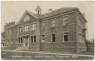
References

  1. "National Register Information System". National Register of Historic Places . National Park Service. March 13, 2009.
  2. History of Abercrombie Township, Richland County, Alma Tweto, Collections of the State Historical Society of North Dakota, Tribune, State Printers and Binders, 1910, Bismarck, ND, pp.158–177 oclc=01773487
  3. The Red River Trails: Oxcart Routes Between St. Paul and the Selkirk Settlement, 1820–1870, Ronda R. Gilman, Carolyn Gilman, Deborah M. Schultz, Minnesota Historical Society Press, 1979, p.41, St. Paul, MN ISBN   0-87351-133-6
  4. Clodfelter, Micheal (2006). The Dakota War: The United States Army Versus the Sioux, 1862–1865. Jefferson, NC: McFarland & company, Inc. Publishers. p. 43. ISBN   0786427264.
  5. The Dakota War of 1862: Minnesota's Other Civil War, Kenneth Carley, p.53-8, 1976, Minnesota Historical Society Press, 345 Kellogg Blvd, St. Paul ISBN   978-0-87351-392-0
  6. Fort Abercrombie, The Weekly Pioneer and Democrat, Oct. 3, 1862, p.1, Minnesota digital newspaper hub, 2024, MNHS, 345 Kellogg Blvd, St. Paul, MN
  7. "Citizens Mustered in at Fort Abercrombie". Richland County, North Dakota Genealogy Trails History Group. Retrieved 2021-05-31.
  8. 1 2 3 Eriksmoen, Curt (6 February 2005). "Bottineau memorialized in both Minnesota and North Dakota". Bismarck Tribune. p. 8. ProQuest   338962560.
  9. From the Red River, The Saint Paul Daily Press, Sept. 6, 1862, Minnesota digital newspaper hub, 2023, MNHS, 345 Kellogg Blvd, St Paul, MN
  10. The Ancestry, Life, and Times of Hon. Henry Hastings Sibley, Nathaniel West, Pioneer Press, 1889, p.281, St. Paul, MN
  11. One Drop In A Sea Of Blue, John B. Lundstrom, Minnesota Historical Society Press, 345 Kellogg Blvd, St Paul, MN, 2012
  12. "The Northern Rangers". Richland County, North Dakota Genealogy Trails History Group. Retrieved 2021-05-31.
  13. Fort Abercrombie DT, 13 Sept. J. McCauly, St. Cloud Democrat, Sept. 25, 1862, Minnesota Digital Newspaper Hub, 2023, MNHS, 345 Kellogg Blvd, St. Paul, MN
  14. Half an hour with Pierre Bottineau, The Saint Paul Daily Press, Sept. 30, 1862, p.2, Minnesota Digital Newspaper Hub, 2023, MNHS, 345 Kellogg Blvd, St. Paul, MN
  15. Fort Abercrombie State Historic Site, State Historical Society of North Dakota [history.nd.gov/historicsites/abercrombie/index.html]
  16. News from Abercrombie, The St. Paul Daily, Sept. 9, 1862, Minnesota Digital Newspaper Hub, 2023, MNHS, 345 Kellogg Blvd, St Paul, MN
  17. 1 2 3 4 Fort Abercrombie 26 September, St. Cloud Democrat, Oct. 2, 1862, p.2 Minnesota Digital Newspaper Hub, 2023, MNHS, 345 Kellogg Blvd, St. Paul, MN
  18. A Brave and Noble Man, The Saint Paul Daily Press, Oct. 10, 1862, Minnesota Digital Newspaper Hub, 2023, MNHS, 345 Kellogg Blvd, St. Paul, MN
  19. Companies A, F, G, and I posted respectively at Fort Abercrombie, Fort Wadsworth, Fort Ripley, and Fort Ridgely: "Trading Gray for Blue: Ex-Confederates Hold the Upper Missouri for the Union", Prologue Magazine, Vol.37, Winter 2005, Michèle T. Butts 2005
  20. Civil War, 8th Regiment Minnesota Infantry, National Park Service, 2023
  21. Andrews, C. C., ed. (1891). Minnesota in the Civil and Indian Wars 1861-1865. St. Paul, Minn: Printed for the state by the Pioneer Press Co. OL   7088819M.
Northern Plains Overland Trails 1866-1877 map on display at the Fort Totten Historic Site Northern Plains Overland Trails 1866-1877 map on display at the Fort Totten Historic Site.jpg
Northern Plains Overland Trails 1866-1877 map on display at the Fort Totten Historic Site

Further reading