
Pittsburgh is a city in and the county seat of Allegheny County, Pennsylvania, United States. It is the second-most populous city in Pennsylvania, after Philadelphia, and the 68th-most populous city in the U.S., with a population of 302,971 as of the 2020 census. The city is located in southwestern Pennsylvania at the confluence of the Allegheny River and the Monongahela River, which combine to form the Ohio River. It anchors the Pittsburgh metropolitan area, which had a population of 2.457 million residents and is the largest metro area in both the Ohio Valley and Appalachia, the second-largest in Pennsylvania, and the 26th-largest in the U.S. Pittsburgh is the principal city of the greater Pittsburgh–Weirton–Steubenville combined statistical area which includes parts of Ohio and West Virginia.

The history of Pittsburgh began with centuries of Native American civilization in the modern Pittsburgh region, known as Jaödeogë’ in the Seneca language. Eventually, European explorers encountered the strategic confluence where the Allegheny and Monongahela Rivers meet to form the Ohio, which leads to the Mississippi River. The area became a battleground when France and Great Britain fought for control in the 1750s. When the British were victorious, the French ceded control of territories east of the Mississippi.

Squirrel Hill is a residential neighborhood in the East End of Pittsburgh, Pennsylvania, United States. The city officially divides it into two neighborhoods, Squirrel Hill North and Squirrel Hill South, but it is almost universally treated as a single neighborhood.

Oakland is the academic and healthcare center of Pittsburgh and one of the city's major cultural centers. Home to three universities, museums, hospitals, shopping venues, restaurants, and recreational activities, this section of the city also includes two city-designated historic districts: the mostly residential Schenley Farms Historic District and the predominantly institutional Oakland Civic Center Historic District, as well as the locally-designated Oakland Square Historic District.

Greenfield is a neighborhood in the city of Pittsburgh, in the state of Pennsylvania in the United States. It is part of the city's 15th Ward along with Hazelwood and Glen Hazel. Greenfield is adjacent to the neighborhoods of Squirrel Hill to the north and east, Hazelwood to the south and west, and Oakland to the northwest. Greenfield includes the geographically and culturally distinct sub-neighborhood of Four Mile Run, also known as Rusyn Valley. Pittsburgh Fire Station #12 is located in the neighborhood on Winterburn Avenue.

Hazelwood is a neighborhood of Pittsburgh, Pennsylvania in the United States. It is represented on Pittsburgh City Council by Barb Warwick. It is bordered by Greenfield and Oakland on the north, Squirrel Hill and Glen Hazel on the east, and the Monongahela River on the south and west. The Pittsburgh Bureau of Fire houses 13 Engine and 13 Truck in Hazelwood.

Downtown Pittsburgh, colloquially referred to as the Golden Triangle, and officially the Central Business District, is the urban downtown center of Pittsburgh, Pennsylvania, United States. It is located at the confluence of the Allegheny River and the Monongahela River whose joining forms the Ohio River. The triangle is bounded by the two rivers.
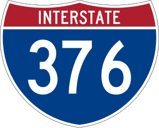
Interstate 376 (I-376) is a major auxiliary route of the Interstate Highway System in the US state of Pennsylvania, located within the Allegheny Plateau. It runs from I-80 near Sharon south and east to a junction with the Pennsylvania Turnpike in Monroeville, after having crossed the Pennsylvania Turnpike at an interchange in Big Beaver. The route serves Pittsburgh and its surrounding areas and is the main access road to Pittsburgh International Airport (PIT). Portions of the route are known as the Beaver Valley Expressway, Southern Expressway, and Airport Parkway. Within Allegheny County, the route runs along the majority of the Penn-Lincoln Parkway, known locally as Parkway West and Parkway East. It is currently the ninth-longest auxiliary Interstate route in the system and second only to I-476 within Pennsylvania.
Highland Park is a neighborhood in the northeastern part of Pittsburgh, Pennsylvania. Highland Park, the neighborhood, fully encompasses the park with the same name.

Swisshelm Park is a neighborhood located in the southeast corner of Pittsburgh, Pennsylvania. It is represented on the Pittsburgh City Council by Barbara Warwick. Swisshelm Park houses PBF 19 Engine, and is covered by PBP Zone 4 and the Bureau of EMS Medic 7.

The Fort Pitt Tunnel is a vehicular tunnel under Mount Washington in Pittsburgh, Pennsylvania. It connects the West End region on the southwest side to the South Shore neighborhood on the northeast side. The adjoining Fort Pitt Bridge on the northeast end connects to Downtown Pittsburgh. The tunnel carries traffic on Interstate 376 (I-376), U.S. Route 22, US 30, and US 19 Truck. The structure comprises two bores, each with two lanes of traffic. The inbound tunnel flows onto the top deck of the double-deck Fort Pitt Bridge, opposite traffic from the lower deck using the outbound tunnel. To accommodate the bridge, the northeast portals of the parallel tunnels are vertically staggered by 30 feet. The tunnel opened in September 1960, a year after the Fort Pitt Bridge.

Uptown or The Bluff is a neighborhood in the city of Pittsburgh, Pennsylvania to the southeast of the city's Central Business District. It is bordered in the north by the Hill District and located across the Monongahela River from South Side. The predominant area zip code is 15219.

Troy Hill is a neighborhood on Pittsburgh, Pennsylvania's North Side. It has a zip code of 15212, and has representation on Pittsburgh City Council by the council member for District 1.

A large metropolitan area that is surrounded by rivers and hills, Pittsburgh has an infrastructure system that has been built out over the years to include roads, tunnels, bridges, railroads, inclines, bike paths, and stairways; however, the hills and rivers still form many barriers to transportation within the city.
South Side Slopes is a neighborhood in Pittsburgh, Pennsylvania's South Side area. The neighborhood comprises the hills from the South Side Flats neighborhood along the Monongahela River from the Liberty Bridge (west) to beyond Josephine Street (east).

Pittsburgh, Pennsylvania, was a thriving and important city during the American Civil War, and provided a significant source of personnel, war materiel, armament, ammunition, and supplies to the Union Army. Situated at the confluence of the Monongahela, Allegheny and Ohio rivers, Pittsburgh was an important transportation hub for both riverine and rail transport, as well as overland via its system of roads.
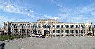
Greenfield Elementary School is a historic school in the Greenfield neighborhood of Pittsburgh, Pennsylvania. The school was designed by the firm of Kiehnel and Elliott and opened in 1922. It is part of the Pittsburgh Public Schools district and serves students in Pre-K through 8th grade.
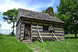
The Neill Log House is a historic log cabin in Schenley Park in Pittsburgh, Pennsylvania, United States. It was built during the second half of the 18th century and has been most commonly attributed to Robert Neill (Neal), with an estimated construction date possibly anywhere from 1765 to 1795. This estimate is based on architectural evidence as well as the large increase in value of the land during Neill's period of ownership which would indicate he made substantial improvements. However, the earlier date of 1765 claimed in some sources, would associate the building with an earlier landowner, Ambrose Newton. In 2024, a dendrochronology study determined that the beam over the fireplace, believed to be original to the house's construction, was dated to be from 1795, which was the date that Robert Neal sold the cabin to John Reed. It is known by records that Robert Neal purchased the land in 1779 and sold the cabin and land in 1795. Extrapolation of the known dates of Robert Neal's purchase and date the property was sold and the large increase in value during Robert Neal's ownership indicating he made substantial improvements likely mean it may have been built by him between 1779-1794.

The Greenfield Bridge, officially known as the Beechwood Boulevard (Greenfield) Bridge II, is a steel arch bridge located in Pittsburgh, Pennsylvania, United States. The bridge connects the neighborhoods of Greenfield and Squirrel Hill across the valley known as Four Mile Run which separates them. The bridge also spans the Parkway East (I-376), which runs along the bottom of the valley.
