Related Research Articles

Jornada del Muerto was the name given by the Spanish conquistadors to the Jornada del Muerto Desert basin, and the almost waterless 90-mile (140 km) trail across the Jornada beginning north of Las Cruces and ending south of Socorro, New Mexico. The name translates from Spanish as "Dead Man's Journey" or "Route of the Dead Man". The trail was part of the Camino Real de Tierra Adentro which led northward from central colonial New Spain, present-day Mexico, to the farthest reaches of the viceroyalty in northern Nuevo México Province.

The Santa Fe Trail was a 19th-century route through central North America that connected Franklin, Missouri, with Santa Fe, New Mexico. Pioneered in 1821 by William Becknell, who departed from the Boonslick region along the Missouri River, the trail served as a vital commercial highway until 1880, when the railroad arrived in Santa Fe. Santa Fe was near the end of El Camino Real de Tierra Adentro which carried trade from Mexico City. The trail was later incorporated into parts of the National Old Trails Road and U.S. Route 66.
There are many historic trails and roads in the United States which were important to the settlement and development of the United States including those used by American Indians.
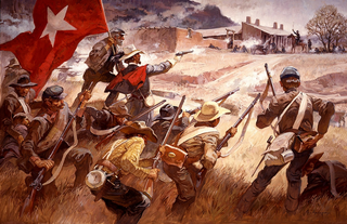
The New Mexico campaign was a military operation of the trans-Mississippi theater of the American Civil War from February to April 1862 in which Confederate Brigadier General Henry Hopkins Sibley invaded the northern New Mexico Territory in an attempt to gain control of the Southwest, including the gold fields of Colorado and the ports of California. Historians regard this campaign as the most ambitious Confederate attempt to establish control of the American West and to open an additional theater in the war. It was an important campaign in the war's Trans-Mississippi Theater, and one of the major events in the history of the New Mexico Territory in the American Civil War.

The Old Spanish Trail is a historical trade route that connected the northern New Mexico settlements of Santa Fe, New Mexico with those of Los Angeles, California and southern California. Approximately 700 mi (1,100 km) long, the trail ran through areas of high mountains, arid deserts, and deep canyons. It is considered one of the most arduous of all trade routes ever established in the United States. Explored, in part, by Spanish explorers as early as the late 16th century, the trail was extensively used by traders with pack trains from about 1830 until the mid-1850s. The area was part of Mexico from Mexican independence in 1821 to the Mexican Cession to the United States in 1848.

The Camino Real de Tierra Adentro, also known as the Silver Route, was a Spanish 2,560-kilometre-long (1,590 mi) road between Mexico City and San Juan Pueblo, New Mexico, that was used from 1598 to 1882. It was the northernmost of the four major "royal roads" that linked Mexico City to its major tributaries during and after the Spanish colonial era.
Fort Selden was a United States Army post, occupying the area in what is now Radium Springs, New Mexico. The site was long a campground along the El Camino Real de Tierra Adentro. It was the site of a Confederate Army camp in 1861. The U.S. Army established Fort Selden in 1865 for the purpose of protecting westward settlers from Native American raids, but the post fell into disrepair after the American Civil War. It was ultimately abandoned in 1891, due in large part to the decision to expand Fort Bliss and the lack of any expenditures for repair of the facility.

Fort Craig was a U.S. Army fort located along El Camino Real de Tierra Adentro, near Elephant Butte Lake State Park and the Rio Grande in Socorro County, New Mexico.
In the history of the American frontier, pioneers built overland trails throughout the 19th century, especially between 1829 and 1870, as an alternative to sea and railroad transport. These immigrants began to settle much of North America west of the Great Plains as part of the mass overland migrations of the mid-19th century. Settlers emigrating from the eastern United States did so with various motives, among them religious persecution and economic incentives, to move from their homes to destinations further west via routes such as the Oregon, California, and Mormon Trails. After the end of the Mexican–American War in 1849, vast new American conquests again encouraged mass immigration. Legislation like the Donation Land Claim Act and significant events like the California Gold Rush further encouraged settlers to travel overland to the west.
Fort Thorn or Fort Thorne, originally Cantonment Garland, was a settlement and military outpost located on the west bank of the Rio Grande, northwest of present-day Hatch, and west of Salem in Doña Ana County, New Mexico, United States. It was named for 1st Lt. Herman Thorn of the 2nd U.S. Infantry drowned in the Colorado River in 1849. He had previously been an aide to General John Garland, the new commander of the Ninth Military District, that encompassed New Mexico Territory in 1853.

Southern Emigrant Trail, also known as the Gila Trail, the Kearny Trail, Southern Trail and the Butterfield Stage Trail, was a major land route for immigration into California from the eastern United States that followed the Santa Fe Trail to New Mexico during the California Gold Rush. Unlike the more northern routes, pioneer wagons could travel year round, mountain passes not being blocked by snows; however, it had the disadvantage of summer heat and lack of water in the desert regions through which it passed in New Mexico Territory and the Colorado Desert of California. Subsequently, it was a route of travel and commerce between the eastern United States and California. Many herds of cattle and sheep were driven along this route and it was followed by the San Antonio-San Diego Mail Line in 1857–1858 and then the Butterfield Overland Mail from 1858 to 1861.
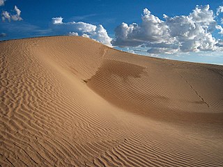
The Samalayuca Dune Fields, more traditionally known as Los Médanos, or more recently referenced as Médanos de Samalayuca are a series of large but separated fields of sand dunes located in the northern part of the Mexican state of Chihuahua. The dune fields are scattered over a wide expanse of desert to the south, southwest and southeast of Ciudad Juárez. The dune fields are located in a 2000 km2 area known as the Samalayuca Desert.
Cooke's Spring, or Cookes Spring, is a spring in Luna County, New Mexico at an elevation of 4839 feet. Cooke's Spring is located at the eastern mouth of the narrow upper Cooke's Canyon, part of what was called Cooke's Pass, a narrow gap, running east and west, through the Cooke's Range.
San Diego Crossing, was a major ford on the Rio Grande, in Doña Ana County, New Mexico during the 19th Century. It was named for San Diego Mountain, on the east side of the Rio Grande, located directly west of the crossing. It was 11 miles north from Doña Ana, New Mexico then 7 miles northwest from the Camino Real to the crossing and 17 miles along the west bank from the crossing to their last camp along the river before their junction with Cooke's Wagon Road.
San Diego Mountain also known as Tonuco Mountain is an American summit 22 miles northwest of Las Cruces, New Mexico in Doña Ana County. Its summit is at an elevation of 4,951 feet.
Fosters Hole or La Tinaja, was a waterhole on the original route of Cooke's Wagon Road in what is now Sierra County, New Mexico. It is located in narrow crevasse at the foot of a cliff in Jug Canyon that is difficult to spot, except from a few vantage points.
Cooke's Wagon Road or Cooke's Road was the first wagon road between the Rio Grande and the Colorado River to San Diego, through the Mexican provinces of Nuevo México, Chihuahua, Sonora and Alta California, established by Philip St. George Cooke and the Mormon Battalion, from October 19, 1846 to January 29, 1847 during the Mexican–American War. It became the first of the wagon routes between New Mexico and California that with subsequent modifications before and during the California Gold Rush eventually became known as the Southern Trail or Southern Emigrant Trail.
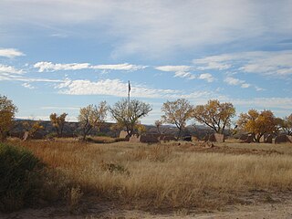
Paraje was a populated place along the east bank of the Rio Grande, in Socorro County, New Mexico, United States, now a ghost town. It is located north northeast of the Fra Cristobal Range.
Contadero is a ghost town along the east bank of the Rio Grande in Socorro County, New Mexico, United States.
San Ygnacio de la Alamosa, also known as Alamosa, is now a ghost town, in Sierra County, New Mexico, United States. San Ygnacio de la Alamosa was founded in 1859 as a native New Mexican colonizing settlement from San Antonio. The site of the new colony was along the west bank of the Rio Grande, 35 miles south of Fort Craig, on the south bank of Alamosa Creek nearby its mouth and confluence with the Rio Grande, in what was then southern Socorro County.