U.S. Route 90 or U.S. Highway 90 (US 90) is an east–west major United States highway in the Southern United States. Despite the "0" in its route number, US 90 never was a full coast-to-coast route. It generally travels near Interstate 10 (I-10) and passes through the southern states of Texas, Louisiana, Mississippi, Alabama, and Florida. US 90 also includes part of the DeSoto Trail between Tallahassee and Lake City, Florida.

U.S. Route 11 or U.S. Highway 11 (US 11) is a major north–south United States Numbered Highway extending 1,645 miles (2,647 km) across the eastern U.S. The southern terminus of the route is at US 90 in Bayou Sauvage National Wildlife Refuge in eastern New Orleans, Louisiana. The northern terminus is at the Rouses Point–Lacolle 223 Border Crossing in Rouses Point, New York. The route continues across the border into Canada as Route 223. US 11, created in 1926, maintains most of its original route. The route north of Knoxville, Tennessee, follows a route similar to Interstate 81 (I-81). While it is signed as a north–south route, it physically travels in a northeast–southwest direction.
U.S. Highway 171 (US 171) is a part of the United States Numbered Highway System and the only route within that system currently located entirely within the state of Louisiana. It spans 177.44 miles (285.56 km) in a north–south direction from the junction of US 90 and Louisiana Highway 14 (LA 14) in Lake Charles to the junction of US 79/US 80 and LA 3094 in Shreveport.

The Lake Pontchartrain Causeway, also known simply as The Causeway, is a fixed link composed of two parallel bridges crossing Lake Pontchartrain in southeastern Louisiana, United States. The longer of the two bridges is 23.83 miles (38.35 km) long. The southern terminus of the causeway is in Metairie, Louisiana, and the northern terminus is in Mandeville, Louisiana. Both are in the New Orleans metropolitan area.

The Huey P. Long Bridge, located in Jefferson Parish, Louisiana, is a cantilevered steel through-truss bridge that carries a two-track railroad line over the Mississippi River at mile 106.1, with three lanes of US 90 on each side of the central tracks. It is several kilometers upriver from the city of New Orleans. The East Bank entrance is at Elmwood, Louisiana, and the West Bank at Bridge City.

Rigolets is a 12.9-kilometre-long (8.0 mi) deepwater strait in Louisiana. "Rigolets" comes from the word rigole, French for 'trench' or 'gutter'. The name is now locally pronounced "RIG-uh-leez".

The Industrial Canal is a 5.5-mile (8.9 km) waterway in New Orleans, Louisiana, United States. The waterway's proper name, as used by the U.S. Army Corps of Engineers and on NOAA nautical charts, is Inner Harbor Navigation Canal (IHNC). The more common "Industrial Canal" name is used locally, both by commercial mariners and by landside residents.
The Chef Menteur Pass is a narrow natural waterway which, along with the Rigolets, connects Lake Pontchartrain and Lake Borgne in New Orleans, Louisiana. It begins at 30°5′45″N89°48′52″W and follows a generally southeastward course. In the days of sailing ships, much commerce from the Gulf of Mexico sailed through the pass and the Rigolets into Lake Pontchartrain to New Orleans and surrounding communities. The Lake Catherine neighborhood of New Orleans is to the east side of the pass. The Venetian Isles neighborhood of New Orleans is to the west of the pass.

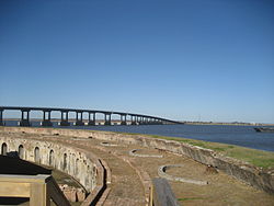
Fort Macomb is a 19th-century United States brick fort in Louisiana, on the western shore of Chef Menteur Pass. It is listed on the National Register of Historic Places. The fort is adjacent to the Venetian Isles community, now legally within the city limits of New Orleans, Louisiana. This community was some miles distant from the city when first built and is still distant from the main developed portion of the city.

Fort Pike State Historic Site is a decommissioned 19th-century United States fort, named after Brigadier General Zebulon Pike. It was built following the War of 1812 to guard the Rigolets pass in Louisiana, a strait from the Gulf of Mexico, via Lake Borgne, to Lake Pontchartrain bordering New Orleans. It was located near the community of Petite Coquille, now within the city limits of New Orleans.

Interstate 10 (I-10), a major transcontinental Interstate Highway in the Southern United States, runs across the southern part of Louisiana for 274.42 miles (441.64 km) from Texas to Mississippi. It passes through Lake Charles, Lafayette, and Baton Rouge, dips south of Lake Pontchartrain to serve the New Orleans metropolitan area, then crosses Lake Pontchartrain and leaves the state.
U.S. Highway 90 (US 90), one of the major east–west U.S. Highways in the Southern United States, runs through southern Louisiana for 297.6 miles (478.9 km), serving Lake Charles, Lafayette, New Iberia, Morgan City, and New Orleans. Much of it west of Lafayette and east of New Orleans has been supplanted by Interstate 10 (I-10) for all but local traffic, but the section between Lafayette and New Orleans runs a good deal south of I-10.

Louisiana Highway 47 (LA 47) is a state highway located in southeastern Louisiana. It runs 15.91 miles (25.60 km) in a general southeast to northwest direction from the Mississippi River levee in Chalmette to the intersection of Hayne Boulevard and Downman Road in New Orleans.

The I-10 Twin Span Bridge, a nearly 5.5-mile (8.9 km) causeway officially known as the Frank Davis "Naturally N'Awlins" Memorial Bridge, consists of two parallel trestle bridges. These parallel bridges cross the eastern end of Lake Pontchartrain in southern Louisiana from New Orleans to Slidell. The current bridge spans were constructed in the second half of the 2000s after the original bridges were extensively damaged by Hurricane Katrina on August 29, 2005. The first span opened to eastbound traffic on July 9, 2009. On April 7, 2010, the second span was opened to traffic and the old twin spans were permanently closed to traffic.

Interstate 55 (I-55) is a part of the Interstate Highway System that spans 964.25 miles (1,551.81 km) from LaPlace, Louisiana, to Chicago, Illinois. Within the state of Louisiana, the highway travels 66 miles (106 km) from the national southern terminus at I-10 in LaPlace to the Mississippi state line north of Kentwood.
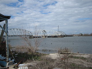
The Maestri Bridge carries U.S. Route 11 (US 11) across Lake Pontchartrain between New Orleans and Slidell, Louisiana, in the United States. The 4.78-mile (7.69 km) bridge was the longest concrete bridge in the world upon completion. It is 35 feet (11 m) wide and has two bascule-type draw spans for passing vessels and barges.
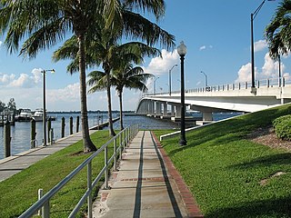
The Edison Bridge is a set of two one-way bridges located in Fort Myers, Florida. Named after inventor Thomas Alva Edison, the two bridges carry each direction of U.S. Highway 41 Business over the Caloosahatchee River, connecting downtown Fort Myers with North Fort Myers.
U.S. Highway 11 (US 11) is a part of the United States Numbered Highway System that spans 1,645 miles (2,647 km) from New Orleans, Louisiana, to Rouses Point, New York. Within the state of Louisiana, the highway travels 31 miles (50 km) from the national southern terminus at US 90 in New Orleans to the Mississippi state line south of Picayune.

The Barryville–Shohola Bridge is the fifth generation of bridges constructed over the Delaware River at the communities of Shohola Township, Pennsylvania and Barryville, New York. The bridge serves both communities, with two major state legislative highways, Pennsylvania Traffic Route 434 and New York State Touring Route 55. The bridge itself is 812 feet (247 m) long and is 23 feet (7.0 m) wide, using four total spans across the river. It is maintained by the NY–PA Joint Interstate Bridge Commission, which is jointly owned by the states of New York and Pennsylvania.

U.S. Highway 51 (US 51) is a part of the United States Numbered Highway System that spans 1,277 miles (2,055 km) from LaPlace, Louisiana to a point north of Hurley, Wisconsin. Within the state of Louisiana, the highway travels 69.12 miles (111.24 km) from the national southern terminus at US 61 in LaPlace to the Mississippi state line north of Kentwood.