Fort Pike

Last updated

Fort Pike
FortPikePostKatrinaBrickCracks1.jpg
Cracks can be seen in the brick structure of Fort Pike after Hurricane Katrina.
Map New Orleans.jpg
Red pog.svg
USA Louisiana location map.svg
Red pog.svg
Usa edcp location map.svg
Red pog.svg
LocationOrleans Parish, Louisiana
Nearest city New Orleans and Slidell
Coordinates 30°9′58″N89°44′13″W / 30.16611°N 89.73694°W / 30.16611; -89.73694
Area9.6 acres (3.9 ha)
Built1819
NRHP reference No. 72000557 [1]
Added to NRHPAugust 14, 1972

Fort Pike State Historic Site is a decommissioned 19th-century United States fort, named after Brigadier General Zebulon Pike. It was built following the War of 1812 to guard the Rigolets pass in Louisiana, a strait from the Gulf of Mexico, via Lake Borgne, to Lake Pontchartrain bordering New Orleans. [2] It was located near the community of Petite Coquille, now within the city limits of New Orleans.

Contents

The fort's ruins have long been a tourist attraction with periods of abandonment. The fort was damaged by the Hurricane Katrina storm surge in 2005, and closed for a period. It also had to be closed following Hurricanes Gustav and Isaac in 2008 and 2012, respectively.

History

Fort Pike Citadel Fort Pike Citadel - 7-2009.jpg
Fort Pike Citadel

A fort had been constructed in 1793 at Petit Coquilles, and was the intended destination of Jones's gunboat squadron prior to the Battle of Lake Borgne. General Jackson's engineer, Major Latour, lamented upon the state of the fort in 1814. [3] Postwar, it was decided to improve the coastal defences with the creation of Fort Pike commencing in 1819 to replace the earlier fort. It was the first of three forts to be constructed in Louisiana under the postwar "Third System", along with Fort Jackson, Louisiana, and Fort Livingston, Louisiana. [4] During the Seminole Wars in Florida through the 1820s, the US temporarily held Seminole Indians here who had been taken prisoner. They were eventually transported to the Seminole Reservation in Indian Territory (now Oklahoma.)

The Louisiana Continental Guard took control of the fort in 1861, just weeks before Louisiana joined the Confederacy and the American Civil War began.

When Union forces captured New Orleans in 1862, the Confederate forces evacuated Fort Pike. The Union reestablished control of the installation, using it as a base for raids. The fort also became a site for training of United States Colored Troops, established in 1864. These soldiers in the South included mostly former slaves. [5] [6]

The fort was abandoned by the United States Army in 1890. No cannon was ever fired in battle at Fort Pike. [6] It was listed on the National Register of Historic Places in 1972. [7] It was maintained as part of a state park, known as the Fort Pike State Historic Site.

Before Hurricane Katrina, the fort's brick-and-mortar structure was decaying. The 2005 storm surge exacerbated the problems. It temporarily completely submerged the entire fort, and destroyed adjacent state park buildings. [7] The site officially reopened on May 2, 2008. [8] However, due to damage caused by Hurricane Gustav in early September 2008, the park was closed indefinitely. As of June 2009, the fort was open. It is undergoing extensive repairs and restoration work. [7] [9] After Hurricane Isaac in 2012, the fort was closed indefinitely pending repairs and debris cleanup. [10]

The fort was re-opened to visitors following Hurricane Isaac, but closed again in February 2015 due to state budget cuts. [11]

Representation in media

Picture of Fort Pike, before Hurricane Katrina, looking toward the Old Rigolets Bridge (US 90) Zebpikesm.jpg
Picture of Fort Pike, before Hurricane Katrina, looking toward the Old Rigolets Bridge (US 90)
Picture of Fort Pike, post-Katrina (New Hwy 90 Bridge in Background) WP 20140312 006.jpg
Picture of Fort Pike, post-Katrina (New Hwy 90 Bridge in Background)
Fort Pike's citadel as seen from atop its rampart (above casemates along the Rigolets, looking south-southwest) Fort Pike's citadel from atop its rampart.jpg
Fort Pike's citadel as seen from atop its rampart (above casemates along the Rigolets, looking south-southwest)
Fort Pike, showing tunnel to casemate northeast of main entrance, casemate itself, gun port, and cannon on display across moat from gun port, between main fort and glacis Tunnel to - and casemate at Fort Pike.jpg
Fort Pike, showing tunnel to casemate northeast of main entrance, casemate itself, gun port, and cannon on display across moat from gun port, between main fort and glacis
Fort Pike's casemates along the Rigolets, December 28, 2002 Fort Pike's casemates along the Rigolets.jpg
Fort Pike's casemates along the Rigolets, December 28, 2002
Fort Pike's landward sides, seen from its glacis, July 2008 Ft. Pike landward from glacis.jpg
Fort Pike's landward sides, seen from its glacis, July 2008
Aerial view of Fort Pike taken November 2019 Fort Pike Aerial Nov 2019 1.jpg
Aerial view of Fort Pike taken November 2019
Aerial view of Fort Pike taken November 2019 Fort Pike Aerial View Nov 2019 2.jpg
Aerial view of Fort Pike taken November 2019

See also

Related Research Articles

<span class="mw-page-title-main">Chalmette, Louisiana</span> Census-designated place in Louisiana, United States

Chalmette is a census-designated place (CDP) in, and the parish seat of, St. Bernard Parish in southeastern Louisiana, United States. The 2010 census reported that Chalmette had 16,751 people; 2011 population was listed as 17,119; however, the pre-Katrina population was 32,069 at the 2000 census. At the 2020 U.S. census, its population rebounded to 21,562. Chalmette is part of the New Orleans–Metairie–Kenner metropolitan statistical area. Chalmette is located east of downtown New Orleans and south of Arabi, towards Lake Borgne.

<span class="mw-page-title-main">Garden District, New Orleans</span> New Orleans neighborhood in Louisiana, United States

The Garden District is a neighborhood of the city of New Orleans, Louisiana, United States. A subdistrict of the Central City/Garden District Area, its boundaries as defined by the New Orleans City Planning Commission are: St. Charles Avenue to the north, 1st Street to the east, Magazine Street to the south, and Toledano Street to the west. The National Historic Landmark district extends a little farther.

<span class="mw-page-title-main">Fort Jackson, Louisiana</span> United States historic place

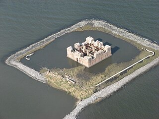
Fort Jackson is a historic masonry fort located 40 miles (64 km) up river from the mouth of the Mississippi River in Plaquemines Parish, Louisiana. It was constructed as a coastal defense of New Orleans, between 1822 and 1832, and it was a battle site during the American Civil War. It is a National Historic Landmark. It was damaged by Hurricanes Katrina and Rita, and its condition is threatened. It is marked Battery Millar on some maps, for the Endicott era work built nearby it.

<span class="mw-page-title-main">Fort St. Philip</span> United States historic place

Fort St. Philip is a historic masonry fort located on the eastern bank of the Mississippi River, about 40 miles (64 km) upriver from its mouth in Plaquemines Parish, Louisiana, just opposite Fort Jackson on the other side of the river. It formerly served as military protection of New Orleans, some 80 miles (130 km) up the river, and of the lower Mississippi River.

Lake St. Catherine is a brackish-water lake that is located in eastern Orleans Parish, within the city limits of New Orleans, between Lake Pontchartrain and Lake Borgne in Louisiana. Between Lake St. Catherine and Lake Borgne was the original Town of Lake Catherine. Established between Unknown Pass and Miller's Ditch, it was settled for railroad workers, trappers, hunters and fishermen.

<span class="mw-page-title-main">Rigolets</span> River in Louisiana, United States

Rigolets is a 12.9 kilometer (8 mi) long deepwater strait in Louisiana. "Rigolets" comes from the word rigole, French for 'trench' or 'gutter'. The name is now locally pronounced "RIG-uh-leez".

<span class="mw-page-title-main">New Orleans Public Library</span> Public library system in New Orleans, Louisiana

The New Orleans Public Library (NOPL) is the public library of the city of New Orleans, Louisiana, United States. Succeeding earlier libraries in the city, it opened in 1897. Three branches were added by 1908. Carnegie library branches were added in 1911 and 1915. By 2005 a dozen branches were open. The main library is listed on the National Register of Historic Places.

<span class="mw-page-title-main">City Park (New Orleans)</span> Public park in New Orleans, Louisiana, US

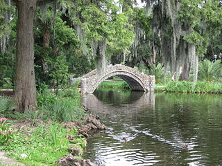
City Park, a 1,300-acre (5.3 km2) public park in New Orleans, Louisiana, is the 87th largest and 20th-most-visited urban public park in the United States. City Park is approximately 50% larger than Central Park in New York City, the municipal park recognized by Americans nationwide as the archetypal urban greenspace. Although it is an urban park whose land is owned by the City of New Orleans, it is administered by the City Park Improvement Association, an arm of state government, not by the New Orleans Parks and Parkways Department. City Park is unusual in that it is a largely self-supporting public park, with most of its annual budget derived from self-generated revenue through user fees and donations. In the wake of the enormous damage inflicted upon the park due to Hurricane Katrina, the Louisiana Department of Culture, Recreation and Tourism began to partially subsidize the park's operations.

<span class="mw-page-title-main">Fort Macomb</span> United States historic place

Fort Macomb is a 19th-century United States brick fort in Louisiana, on the western shore of Chef Menteur Pass. It is listed on the National Register of Historic Places. The fort is adjacent to the Venetian Isles community, now legally within the city limits of New Orleans, Louisiana. This community was some miles distant from the city when first built and is still distant from the main developed portion of the city.

<span class="mw-page-title-main">The Cabildo</span> Building in New Orleans, Louisiana

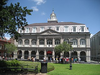
The Cabildo, originally called "Casa Capitular", is a historical building in New Orleans, Louisiana. Originally the seat of Spanish colonial city hall, the building now forms part of the Louisiana State Museum. It is located along Jackson Square, adjacent to St. Louis Cathedral.

<span class="mw-page-title-main">Fort Proctor</span> United States historic place

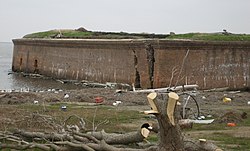
Fort Proctor is a ruined 19th century fort in St. Bernard Parish, Louisiana, USA. It is also known as Fort Beauregard or Beauregard's Castle. The fort is on the shore of Lake Borgne just north of the mouth of Bayou Yscloskey. At the time it was built in the 1850s, there was also an adjacent railroad port called "Proctorville".

<span class="mw-page-title-main">New Orleans East</span> Eastern section of New Orleans

New Orleans East is the eastern section of New Orleans, Louisiana, the newest section of the city. This collection neighborhood sub divisions represents 65% of the city's total land area, but it is geographically isolated from the rest of the city by the Inner Harbor Navigational Canal. It is surrounded by water on all sides, bounded by the Industrial Canal, Gulf Intracoastal Waterway, Lake Pontchartrain, Lake Borgne, and the Rigolets, a long deep-water strait connecting the two lakes. Interstate 10 (I-10) splits the area nearly in half, and Chef Menteur Hwy, Downman Rd, Crowder Blvd, Dwyer Rd, Lake Forest Blvd, Read Blvd, Bullard Ave, Michoud Blvd, Hayne Blvd, Morrison Rd, Bundy Rd, and Almonaster Ave serve as major streets and corridors.

<span class="mw-page-title-main">St. Bernard State Park</span> State park in Louisiana, United States

St. Bernard State Park is a state park located in the American state of Louisiana, on a tract of land in St. Bernard Parish, between the towns of Poydras and Caernarvon. Though located only approximately eighteen miles southeast of New Orleans, attendance had been fledgling at the park for years, ranking among the least visited in the state.

<span class="mw-page-title-main">New Orleans Museum of Art</span> Art museum in New Orleans, Louisiana

The New Orleans Museum of Art is the oldest fine arts museum in the city of New Orleans. It is situated within City Park, a short distance from the intersection of Carrollton Avenue and Esplanade Avenue, and near the terminus of the "Canal Street - City Park" streetcar line. It was established in 1911 as the Delgado Museum of Art.

<span class="mw-page-title-main">Jackson Barracks</span> United States historic place

Jackson Barracks is the headquarters of the Louisiana National Guard. It is located in the Lower 9th Ward of New Orleans, Louisiana. The base was established in 1834 and was originally known as New Orleans Barracks. On July 7, 1866, it was renamed in honor of Andrew Jackson. The National Register of Historic Places listed Jackson Barracks in 1976.

Bayou St. John submarine Submarine built for the Confederate States Navy

The Bayou St. John Confederate Submarine is an early military submarine built for use by the Confederate States of America during the American Civil War.

<span class="mw-page-title-main">Grand Isle State Park (Louisiana)</span> State park in Louisiana, United States

Grand Isle State Park, lies at the eastern tip of Grand Isle, a barrier island in Jefferson Parish, Louisiana, U.S.A. Grand Isle is the only inhabited barrier island in the state.

<span class="mw-page-title-main">Battle of Lake Borgne</span> Naval battle fought between Britain and the United States in the War of 1812

The Battle of Lake Borgne was a coastal engagement between the Royal Navy and the U.S. Navy in the American South theatre of the War of 1812. It occurred on December 14, 1814 on Lake Borgne. The British victory allowed them to disembark their troops unhindered nine days later and to launch an offensive upon New Orleans on land.

References

  1. "National Register Information System". National Register of Historic Places . National Park Service. July 9, 2010.
  2. Louisiana Department of Culture, Recreation and Tourism. "Fort Pike Historical Marker".
  3. Latour (1816) p.7 'The fort of Petites Coquilles was not finished at the time of the invasion, nor was it in a condition to make an ordinary resistance'.
  4. Coleman 2005, p. 136.
  5. "Fort Pike State Historic Site". Louisiana Department of Culture, Recreation & Tourism. Retrieved March 14, 2014.
  6. 1 2 "Civil War Military Sites". Louisiana Department of Culture, Recreation and Tourism. Archived from the original on April 14, 2006. Retrieved March 21, 2006.
  7. 1 2 3 Purpura, Paul (March 21, 2006). "Hurricane Katrina devastated Forts Jackson, St. Philip and Pike". Times-Picayune. pp. A-1, A-11. Retrieved March 21, 2006.
  8. "Louisiana State Parks Press Release". www.crt.state.la.us. Archived from the original on July 1, 2008. Retrieved June 6, 2022.
  9. "Status of Hurricane-Impacted Sites". Louisiana Department of Culture, Recreation and Tourism. Archived from the original on May 25, 2006. Retrieved March 21, 2006.
  10. "Fort Pike State Historic Site". Louisiana State Parks. Louisiana Department of Culture, Recreation and Tourism. Retrieved October 17, 2012.
  11. "Louisiana closes unique Fort Pike to visitors, lays off staff amid budget cuts" . Retrieved May 1, 2015.

Commons-logo.svg Media related to Fort Pike at Wikimedia Commons