
Browns Park National Wildlife Refuge is a 13,450-acre (5,440 ha) U.S. National Wildlife Refuge located in northwestern Colorado. It is located in Moffat County in the extreme northwestern corner of the state, in an isolated mountain valley of Browns Park on both sides of the Green River, approximately 25 miles (40 km) below Flaming Gorge Dam. Established in 1965, the refuge is managed by the United States Fish and Wildlife Service office in Maybell, Colorado. The refuge is approximately 53 miles (85 km) northwest of Maybell on State Highway 318. The refuge consists of bottomland and adjacent benchland. The western border of the refuge is the Colorado-Utah state line. The refuge is surrounded by adjacent lines of the Bureau of Land Management. The refuge contains the site of the former Fort Davy Crockett that was constructed in 1837 to protect trappers against attacks by Blackfoot Native Americans.

The Klamath Basin National Wildlife Refuge Complex is a wildlife preserve operated by the United States Fish and Wildlife Service in the Klamath Basin of southern Oregon and northern California near Klamath Falls, Oregon. It consists of Bear Valley, Klamath Marsh and Upper Klamath National Wildlife Refuge (NWR) in southern Oregon and Lower Klamath, Tule Lake, and Clear Lake NWR in northern California.

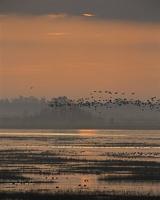
The Atlantic Flyway is a major north-south flyway for migratory birds in North America. The route generally starts in Greenland, then follows the Atlantic coast of Canada, then south down the Atlantic Coast of the United States to the tropical areas of South America and the Caribbean. Every year, migratory birds travel up and down this route following food sources, heading to breeding grounds, or traveling to overwintering sites.

Great Bay is located in southern New Jersey's Atlantic Coastal Plain in Ocean and Atlantic Counties, about ten miles (16 km) north of Atlantic City and is about 5.5 miles northwest of Brigantine, and 5.5 miles southwest of Beach Haven. The Mullica River flows into the bay, and together they form the Mullica River - Great Bay estuary habitat. The bay is connected to the Atlantic Ocean via the Little Egg Inlet. Great Bay is considered one of the least-disturbed marine wetlands habitats in the northeastern United States.
Bogue Chitto National Wildlife Refuge is located 60 mi (97 km) northeast of New Orleans, Louisiana, U.S., and encompasses 36,000 acres (150 km2) of Pearl River Basin swampland.
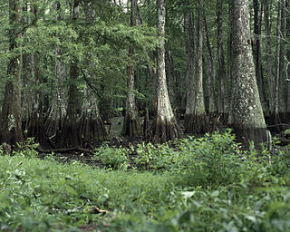
Bayou Cocodrie National Wildlife Refuge was established in 1992 to protect some of the last remaining, least-disturbed bottomland hardwood forest tracts in the Lower Mississippi Valley. These wooded wetlands, oxbow lakes, brakes, sloughs, and bayous, are inhabited seasonally by over 150 species of migratory birds, including forest-breeding birds, water birds, and waterfowl. The 15,155-acre (61.33 km2) refuge is located in Concordia Parish, Louisiana, 10 miles (16 km) southwest of Vidalia, Louisiana. It is named for the state-designated scenic river which runs through its center.
The Atchafalaya National Wildlife Refuge is located about 30 miles (48 km) west of Baton Rouge, Louisiana, and one mile (1.6 km) east of Krotz Springs, Louisiana, lies just east of the Atchafalaya River. In 1988 under the administration of Governor Foster the "Atchafalaya Basin Master Plan" was implemented that combined the 11,780-acre (4,770 ha) Sherburne Wildlife Management Area (WMA), the 15,220-acre (6,160 ha) Atchafalaya National Wildlife Refuge, and the 17,000-acre (6,900 ha) U.S. Army Corps of Engineers' Bayou Des Ourses into the Sherburne Complex Wildlife Management Area.
Big Branch Marsh National Wildlife Refuge was formed in 1994. It is composed of 15,000 acres (6,100 ha) of pine flatwoods, oak rides and coastal marsh. This diverse habitat is an example of the natural coastline of Lake Pontchartrain surrounded by fast developing communities.

Breton National Wildlife Refuge is located in southeastern Louisiana in the offshore Breton Islands and Chandeleur Islands. It is located in the Gulf of Mexico and is accessible only by boat. The refuge was established in 1904 through executive order of President Theodore Roosevelt and is the second-oldest refuge in the National Wildlife Refuge System.
The Delta National Wildlife Refuge is located 10 miles (16 km) east of Venice, Louisiana along the Mississippi River. The area formed when a breach in the natural levee of the Mississippi River occurred in 1862 approximately 100 miles (160 km) below New Orleans, Louisiana. The 48,000-acre (190 km2) refuge was purchased in 1935 with the primary purpose to provide sanctuary and habitat to wintering waterfowl. Access is by boat only.
Lacassine National Wildlife Refuge is located in Cameron and Evangeline Parishes in southwestern Louisiana, was established in 1937 by Executive Order No. 7780 as "a refuge and breeding ground for migratory birds and other wildlife." The refuge is nearly 35,000 acres (140 km2) in size, including 653 acres (2.64 km2) leased from the Cameron Parish School Board. The Evangeline Parish unit is called Duralde Prairie and is currently being developed. It is located south of the city of Eunice.
Lake Ophelia National Wildlife Refuge was established in 1988 to protect the Mississippi/Red River floodplain ecosystem. The refuge is located in Avoyelles Parish, Louisiana, east central Louisiana. The refuge is named for its most prominent water body, the 350-acre (1.4 km2) Lake Ophelia that was at one time a channel of the nearby Red River of the South.

The Sonny Bono Salton Sea National Wildlife Refuge is located in the Imperial Valley of California, 40 miles (64 km) north of the Mexican border. Situated at the southern end of the Salton Sea, the refuge protects one of the most important nesting sites and stopovers along the Pacific Flyway. Despite its location in the Colorado Desert, a subdivision of the larger Sonoran Desert, the refuge contains marine, freshwater, wetland, and agricultural habitats which provide sanctuary for hundreds of birds and wetland species, including several that have been listed as endangered or sensitive by the U.S. Fish and Wildlife Service.
Maine Coastal Islands National Wildlife Refuge contains more than 50 offshore islands and four coastal parcels, totaling more than 8,100 acres. The complex spans more than 250 miles (400 km) of Maine coastline and includes five national wildlife refuges—Petit Manan, Cross Island, Franklin Island, Seal Island, and Pond Island. The U.S. Fish and Wildlife Service manages the refuge complex as part of the National Wildlife Refuge System.

Glenn Martin National Wildlife Refuge includes the northern half of Smith Island, which lies 11 miles (18 km) west of Crisfield, Maryland, and Watts Island, which is located between the eastern shore of Virginia and Tangier Island. Both islands are situated in the lower Chesapeake Bay.
Hillside National Wildlife Refuge is one of seven refuges in the Theodore Roosevelt National Wildlife Refuge Complex. The refuge is an oasis of wildlife habitat surrounded by agriculture. Bounded on the east side by the unique loess bluffs of eastern Mississippi, this 15,572-acre (63.02 km2) refuge was named to reflect its location at the base of the bluffs.

The Supawna Meadows National Wildlife Refuge is a component of the Delaware River estuary in Salem County, New Jersey, it is just north of the Salem River and south of Pennsville.

Mackay Island National Wildlife Refuge was established in 1960 to provide habitat for migratory waterfowl, primarily the greater snow goose. It is located almost entirely on Knotts Island in the Currituck Sound between Back Bay in Virginia Beach, Virginia, and the open sound in North Carolina. Most of the refuge lies within North Carolina but some of it is in Virginia. The refuge is primarily made up of marsh habitat. This area has long been recognized for supporting significant migratory waterfowl populations and sport fishery resources, and is part of the Charles Kuralt Trail.
Pass a Loutre Wildlife Management Area (WMA) is a 115,000-acre (47,000 ha) protected wetland in Plaquemines Parish, Louisiana, United States. The WMA is located due south and bordering the 48,000 acre Delta National Wildlife Refuge, accessible only by air or boat, contains the Pass A L'Outre Lighthouse, and Port Eads is within the boundary.

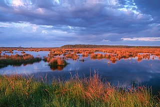
The fauna of Louisiana is characterized by the region's low swamplands, bayous, creeks, woodlands, coastal marshlands and beaches, and barrier islands covering an estimated 20,000 square miles, corresponding to 40 percent of Louisiana's total land area. Southern Louisiana contains up to fifty percent of the wetlands found in the Continental United States, made up of countless bayous and creeks.


