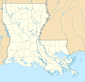
Alexandria is the ninth-largest city in the state of Louisiana and is the parish seat of Rapides Parish, Louisiana, United States. It lies on the south bank of the Red River in almost the exact geographic center of the state. It is the principal city of the Alexandria metropolitan area which encompasses all of Rapides and Grant parishes. Its neighboring city is Pineville. In 2010, the population was 47,723, an increase of 3 percent from the 2000 census.

Donaldsonville is a small city in, and the parish seat of, Ascension Parish in south Louisiana, United States, located along the River Road of the west bank of the Mississippi River. The population was 7,436 at the 2010 census, a decrease of more than 150 from the 7,605 tabulation in 2000. Donaldsonville is part of the Baton Rouge Metropolitan Statistical Area.

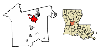
Pineville is a city in Rapides Parish, Louisiana, United States. It is located across the Red River from the larger Alexandria. Pineville is hence part of the Alexandria Metropolitan Statistical Area. The population was 14,555 at the 2010 census. It had been 13,829 in 2000; population hence grew by 5 percent over the preceding decade.
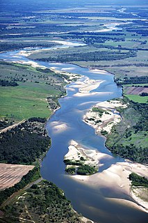
The Red River, or sometimes the Red River of the South, is a major river in the Southern United States. It was named for its reddish water color from passing through red-bed country in its watershed. It is one of several rivers with that name. Although once a tributary of the Mississippi River, the Red River is now a tributary of the Atchafalaya River, a distributary of the Mississippi that flows separately into the Gulf of Mexico. This confluence is connected to the Mississippi River by the Old River Control Structure.

The Ouachita River is a 605-mile-long (974 km) river that runs south and east through the U.S. states of Arkansas and Louisiana, joining the Tensas River to form the Black River near Jonesville, Louisiana. It is the 25th-longest river in the United States.

U.S. Route 165 is a north–south United States highway spur of U.S. Highway 65. It currently runs for 412 miles (663 km) from U.S. Route 90 in Iowa, Louisiana north to U.S. Highway 70 in North Little Rock, Arkansas. The route passes through the states of Arkansas and Louisiana. It passes through the cities of Monroe and Alexandria in Louisiana. A segment of US 165 serves as a routing of the Great River Road within Arkansas.

Kisatchie National Forest, the only National forest in Louisiana, United States, is located in the forested piney hills and hardwood bottoms of seven central and northern parishes. It is part of the Cenozoic uplands and has large areas of longleaf pine forests. It is one of the largest pieces of natural landscape in Louisiana, with some 604,000 acres (2,440 km2) of public land, more than half of which is vital longleaf pine and flatwoods vegetation. These support many rare plant and animal species. There are also rare habitats, such as hillside seepage bogs and calcareous prairies. The forest also contains and provides a buffer for the Kisatchie Hills Wilderness, a nationally designated wilderness area that contributes to protecting biodiversity of the coastal plain region of the United States.

The National Register of Historic Places in the United States is a register including buildings, sites, structures, districts, and objects. The Register automatically includes all National Historic Landmarks as well as all historic areas administered by the U.S. National Park Service. Since its introduction in 1966, more than 90,000 separate listings have been added to the register.
The Illinois Historic Preservation Division, formerly Illinois Historic Preservation Agency, is a governmental agency of the U.S. state of Illinois, and is a division of the Illinois Department of Natural Resources. It is tasked with the duty of maintaining State-owned historic sites, and maximizing their educational and recreational value to visitors or on-line users. In addition, it manages the process for applications within the state for additions to the National Register of Historic Places.
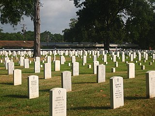
Alexandria National Cemetery is a United States National Cemetery located in the city of Pineville, in Rapides Parish, Louisiana. It occupies approximately 8 acres (3.2 ha), and is site to 10,164 interments as of the end of 2005.

Central Louisiana (Cenla), also known as the Crossroads, is the region of the U.S. state of Louisiana.

John Randolph Thornton was a United States Senator from Louisiana.

Fort DeRussy is a United States military reservation in the Waikiki area of Honolulu, Hawaii, under the jurisdiction of the United States Army. Unfenced and largely open to public traffic, the installation consists mainly of landscaped greenspace. The former Battery Randolph now houses the U.S. Army Museum of Hawaiʻi, which is open to the public. The Hale Koa Hotel, an Armed Forces Recreation Center, and the Daniel K. Inouye Asia-Pacific Center for Security Studies are also located on Fort DeRussy.
Louisiana State Seminary of Learning & Military Academy was the former name of the current university now known as Louisiana State University (LSU).

The Port Hudson State Historic Site is located on the Mississippi River north of Baton Rouge in East Feliciana Parish, Louisiana, just outside the limits of Port Hudson and in the vicinity of Jackson. The site preserves a portion of the fortifications and battle area of the longest siege in American history, during the American Civil War from May 23 through July 9, 1863. The state of Louisiana maintains the site, which includes a museum about the siege, artillery displays, redoubts, and interpretive plaques. Living history re-enactments are held each year. It was designated a National Historic Landmark in 1974, significant as the first place where African-American military units fought for the Union Army under African-American field leadership.
Fort Randolph may refer to:

Fort Buhlow is an American Civil War fort site located in Pineville, Louisiana. It was added to the National Register of Historic Places on June 1, 1981. It was one of two forts built for the Confederate States Army by local plantation slave labor in March 1865 to prevent anticipated Union attacks. Alphonse Buhlow was the military engineer for the construction of the forts and this one was named for him.
Fort Randolph was built in late 1864 by Confederate force as a defense against an expected third invasion by Union forces of the Louisiana Red River Valley in 1865. The fort was named for Captain Chistopher M. Randolph who was in charge of its construction.

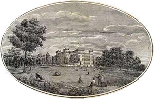
The Old LSU Site is located in Pineville, Louisiana. In November 1859, the institution's main building was completed. The institution's first superintendent was Major William Tecumseh Sherman. On January 2, 1860, the college opened with five professors and 19 cadets. In March 1860, the school's name was changed to Louisiana State Seminary of Learning & Military Academy. The state's legislature allowed for as many as 150 cadets, with scholarships for boarding expenses. The total number of cadets eventually reached 73. The cadets were referred to as "beneficiary" cadets.