Plaquemines Parish is a parish located in the U.S. state of Louisiana. With a population of 23,515 at the 2020 census, the parish seat is Pointe à la Hache and the largest community is Belle Chasse. The parish was formed in 1807.

Plaquemine is a city in and the parish seat of Iberville Parish, Louisiana, United States. It is part of the Baton Rouge metropolitan statistical area. At the 2010 United States census, the population was 7,119; the 2020 census determined its population was 6,269.
Pointe à la Hache is a census-designated place (CDP) and unincorporated community in Plaquemines Parish, Louisiana, United States. Located on the east bank of the Mississippi River, the village has been the seat for Plaquemines Parish since the formation of the parish. As of the 2020 census, its population was 183, less than half its 1930 population. It suffered severe damage from Hurricane Katrina in 2005 and Tropical Storm Lee in 2011, and as of September 2023 was listed by the New York Times as "(inundated)".

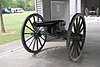
Fort Jackson is a historic masonry fort located 40 miles (64 km) up river from the mouth of the Mississippi River in Plaquemines Parish, Louisiana. It was constructed as a coastal defense of New Orleans, between 1822 and 1832, and it was a battle site during the American Civil War. It is a National Historic Landmark. It was damaged by Hurricanes Katrina and Rita, and its condition is threatened. It is marked Battery Millar on some maps, for the Endicott era work built nearby it.

Fort St. Philip is a historic masonry fort located on the eastern bank of the Mississippi River, about 40 miles (64 km) upriver from its mouth in Plaquemines Parish, Louisiana, just opposite Fort Jackson on the other side of the river. It formerly served as military protection of New Orleans, some 80 miles (130 km) up the river, and of the lower Mississippi River.

John Leigh "Jay" Dardenne, Jr. is an American lawyer and politician from Baton Rouge, Louisiana, who is serving as commissioner of administration for Democratic Governor John Bel Edwards. A Republican, Dardenne served as the 53rd lieutenant governor of his state from 2010 to 2016. Running as a Republican, he won a special election for lieutenant governor held in conjunction with the regular November 2, 2010 general election. At the time, Dardenne was Louisiana secretary of state. Formerly, Dardenne was a member of the Louisiana State Senate for the Baton Rouge suburbs, a position he filled from 1992 until his election as secretary of state on September 30, 2006.
Port Eads is a populated place at the southern tip of the Mississippi River, also known as South Pass, in Plaquemines Parish, Louisiana, United States. The Mississippi River in the 100-mile-plus stretch between the Port of New Orleans and the Gulf of Mexico frequently suffered from silting up of its outlets, stranding ships, or making parts of the river unnavigable for a period of time. The port was renamed in honor of James Buchanan Eads whose design for the south pass of the Mississippi River solved this problem. It was designated as a National Historic Civil Engineering Landmark by the American Society of Civil Engineers in 1982.

Fort Pike State Historic Site is a decommissioned 19th-century United States fort, named after Brigadier General Zebulon Pike. It was built following the War of 1812 to guard the Rigolets pass in Louisiana, a strait from the Gulf of Mexico, via Lake Borgne, to Lake Pontchartrain bordering New Orleans. It was located near the community of Petite Coquille, now within the city limits of New Orleans.

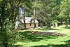
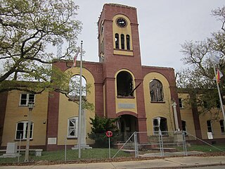
St. Bernard State Park is a state park located in the American state of Louisiana, on a tract of land in St. Bernard Parish, between the towns of Poydras and Caernarvon. Though located only approximately eighteen miles southeast of New Orleans, attendance had been fledgling at the park for years, ranking among the least visited in the state.

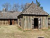
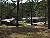
Fort Jesup, also known as Fort Jesup State Historic Site or Fort Jesup or Fort Jesup State Monument, was built in 1822, 22 miles (35 km) west of Natchitoches, Louisiana, to protect the United States border with New Spain and to return order to the Neutral Strip. Originally named Cantonment Jesup, the fort operated from 1822 until 1846. After the abandonment of the fort in 1846, the United States federal government continued to own the abandoned fort site until the privatization of the site in 1869.

Marksville Prehistoric Indian Site, also known as the Marksville site, is a Marksville culture archaeological site located 1 mile (1.6 km) southeast of Marksville in Avoyelles Parish, Louisiana. The site features numerous earthworks built by the prehistoric indigenous peoples of southeastern North America.

Coles Creek culture is a Late Woodland archaeological culture in the Lower Mississippi valley in the Southeastern Woodlands. It followed the Troyville culture. The period marks a significant change in the cultural history of the area. Population increased dramatically and there is strong evidence of a growing cultural and political complexity, especially by the end of the Coles Creek sequence. Although many of the classic traits of chiefdom societies are not yet manifested, by 1000 CE the formation of simple elite polities had begun. Coles Creek sites are found in Arkansas, Louisiana, and Mississippi. It is considered ancestral to the Plaquemine culture.
The Plaquemine culture was an archaeological culture centered on the Lower Mississippi River valley. It had a deep history in the area stretching back through the earlier Coles Creek and Troyville cultures to the Marksville culture. The Natchez and related Taensa peoples were their historic period descendants. The type site for the culture is the Medora site in Louisiana; while other examples include the Anna, Emerald, Holly Bluff, and Winterville sites in Mississippi.

William Harold "Billy" Nungesser is an American politician serving as the 54th lieutenant governor of Louisiana since 2016. A member of the Republican Party, Nungesser is also the former president of the Plaquemines Parish Commission, having been re-elected to a second four-year term in the 2010 general election in which he topped two opponents with more than 71 percent of the vote. His second term as parish president began on January 1, 2011, and ended four years later.

The following outline is provided as an overview of and topical guide to the U.S. state of Louisiana:

Fort DeRussy, located south of Alexandria, Louisiana, and four miles (6 km) north of Marksville, was a Confederate earthwork stronghold during the American Civil War. It was built in 1862 to defend the lower Red River Valley in Louisiana. Located in Avoyelles Parish, the fort, cemetery and water batteries were designated as a state historic site in 1994. The fort and the water battery were listed on the National Register of Historic Places in 2016.

Plaquemine Lock State Historic Site, located in Plaquemine, Louisiana, commemorates an early example of hydraulic engineering design and the historic significance of Bayou Plaquemine, an important navigable waterway that was once a distributary of the Mississippi River. Bayou Plaquemine promoted settlement beginning in the 18th century and helped the area economically by providing an access route between southwestern Louisiana and the Mississippi via the Atchafalaya Basin.

The Marksville culture was an archaeological culture in the lower Lower Mississippi valley, Yazoo valley, and Tensas valley areas of present-day Louisiana, Mississippi, Arkansas, and extended eastward along the Gulf Coast to the Mobile Bay area, from 100 BCE to 400 CE. This culture takes its name from the Marksville Prehistoric Indian Site in Avoyelles Parish, Louisiana. Marksville Culture was contemporaneous with the Hopewell cultures within present-day Ohio and Illinois. It evolved from the earlier Tchefuncte culture and into the Baytown and Troyville cultures, and later the Coles Creek and Plum Bayou cultures. It is considered ancestral to the historic Natchez and Taensa peoples.
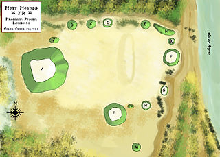
The Mott Archaeological Preserve or Mott Mounds Site is an archaeological site in Franklin Parish, Louisiana on the west bank of Bayou Macon. It originally had eleven mounds with components from the Marksville, Troyville, Coles Creek, and Plaquemine periods. It was at one time one of the largest mound centers in the Southeast and has one of the largest mounds in Louisiana with a base which cover more than two acres. It was purchased by the Archaeological Conservancy in 2002. and is now used for research and educational purposes.