
The Mississippi River is the primary river of the largest drainage basin in the United States. From its traditional source of Lake Itasca in northern Minnesota, it flows generally south for 2,340 miles (3,766 km) to the Mississippi River Delta in the Gulf of Mexico. With its many tributaries, the Mississippi's watershed drains all or parts of 32 U.S. states and two Canadian provinces between the Rocky and Appalachian mountains. The river either borders or passes through the states of Minnesota, Wisconsin, Iowa, Illinois, Missouri, Kentucky, Tennessee, Arkansas, Mississippi, and Louisiana. The main stem is entirely within the United States; the total drainage basin is 1,151,000 sq mi (2,980,000 km2), of which only about one percent is in Canada. The Mississippi ranks as the world's tenth-largest river by discharge flow, and the largest in North America.

Morganza is an incorporated village near the Mississippi River in Pointe Coupee Parish, Louisiana, United States. The population was 610 at the 2010 census, down from 659 in 2000. As of 2020 the population was 525. It is part of the Baton Rouge metropolitan statistical area. The village's zip code is 70759. The Morganza Spillway, a flood control structure between the Mississippi River and the Atchafalaya Basin, is located nearby.

The Atchafalaya River is a 137-mile-long (220 km) distributary of the Mississippi River and Red River in south central Louisiana in the United States. It flows south, just west of the Mississippi River, and is the fifth largest river in North America, by discharge. The name Atchafalaya comes from Choctaw for 'long river', from hachcha, 'river', and falaya, 'long'.

The Mississippi River Delta is the confluence of the Mississippi River with the Gulf of Mexico in Louisiana, southeastern United States. The river delta is a three-million-acre area of land that stretches from Vermilion Bay on the west, to the Chandeleur Islands in the east, on Louisiana's southeastern coast. It is part of the Gulf of Mexico and the Louisiana coastal plain, one of the largest areas of coastal wetlands in the United States. The Mississippi River Delta is the 7th largest river delta on Earth (USGS) and is an important coastal region for the United States, containing more than 2.7 million acres of coastal wetlands and 37% of the estuarine marsh in the conterminous U.S. The coastal area is the nation's largest drainage basin and drains about 41% of the contiguous United States into the Gulf of Mexico at an average rate of 470,000 cubic feet per second.

The Old River Control Structure is a floodgate system in a branch of the Mississippi River in central Louisiana. It regulates the flow of water from the Mississippi into the Atchafalaya River, thereby preventing the Mississippi River from changing course. Completed in 1963, the complex was built by the U.S. Army Corps of Engineers in a side channel of the Mississippi known as "Old River", between the Mississippi's current channel and the Atchafalaya Basin, a former channel of the Mississippi.

The Bonnet Carré Spillway is a flood control operation in the Lower Mississippi Valley. Located in St. Charles Parish, Louisiana, about 12 miles (19 km) west of New Orleans, it allows floodwaters from the Mississippi River to flow into Lake Pontchartrain and thence into the Gulf of Mexico. The spillway was constructed between 1929 and 1931, following the Great Mississippi Flood of 1927, and has been designated as a National Historic Civil Engineering Landmark by the American Society of Civil Engineers.

The Atchafalaya Basin, or Atchafalaya Swamp, is the largest wetland and swamp in the United States. Located in south central Louisiana, it is a combination of wetlands and river delta area where the Atchafalaya River and the Gulf of Mexico converge. The river stretches from near Simmesport in the north through parts of eight parishes to the Morgan City southern area.
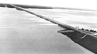
The Morganza Spillway or Morganza Control Structure is a flood-control structure in the U.S. state of Louisiana. It is located along the western bank of the Lower Mississippi River at river mile 280, near Morganza in Pointe Coupee Parish. The spillway stands between the Mississippi and the Morganza Floodway, which leads to the Atchafalaya Basin and the Atchafalaya River in south-central Louisiana. Its purpose is to divert water from the Mississippi River during major flood events by flooding the Atchafalaya Basin, including the Atchafalaya River and the Atchafalaya Swamp. The spillway and adjacent levees also help prevent the Mississippi from changing its present course through the major port cities of Baton Rouge and New Orleans to a new course down the Atchafalaya River to the Gulf of Mexico. The Morganza Spillway, operated by the U.S. Army Corps of Engineers, was opened during the 1973 and 2011 Mississippi River floods.
Elliot City is a ghost town that was located in Pointe Coupee Parish's 10th Ward, approximately 6 miles west of Livonia, Louisiana United States. The site of the town itself is located at coordinates 30.555942, -91.662475, and is covered or partially covered by the current U.S. Route 190 roadway.
East Krotz Springs is a ghost town that was located in Pointe Coupee Parish's 1st Ward, approximately 12 miles west of Livonia, Louisiana, United States. The site of the town itself is located at coordinates 30°32'12.87"N, 91°44'24.59"W, and is abandoned. United States Geological Survey maps from 1948 show the town to be located on the east bank of the Atchafalaya River at the mouth of Bayou Sherman, directly across from Krotz Springs, south of the railroad bridge.
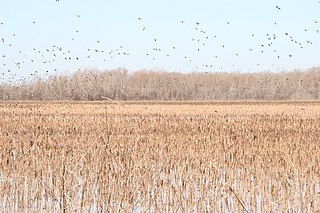
The Grand Cote National Wildlife Refuge was established in 1989 as part of the North American Waterfowl Management Plan. It is a 6,000-acre (24 km2) reserve located in Avoyelles Parish, near Marksville, Louisiana, in the United States.
The Water Resources Development Act of 2000, Pub. L. 106–541 (text)(PDF), was enacted by Congress of the United States on December 11, 2000. Most of the provisions of WRDA 2000 are administered by the United States Army Corps of Engineers.
The Atchafalaya National Wildlife Refuge is located about 30 miles (48 km) west of Baton Rouge, Louisiana, and one mile (1.6 km) east of Krotz Springs, Louisiana, lies just east of the Atchafalaya River. In 1988 under the administration of Governor Foster the "Atchafalaya Basin Master Plan" was implemented that combined the 11,780-acre (4,770 ha) Sherburne Wildlife Management Area (WMA), the 15,220-acre (6,160 ha) Atchafalaya National Wildlife Refuge, and the 17,000-acre (6,900 ha) U.S. Army Corps of Engineers' Bayou Des Ourses into the Sherburne Complex Wildlife Management Area.
Loggy Bayou is a 17.3-mile-long (27.8 km) stream in northwestern Louisiana which connects Lake Bistineau with the Red River. Bistineau is the reservoir of Dorcheat Bayou, which flows 115 miles (185 km) southward from Nevada County, Arkansas, into Webster Parish. Loggy Bayou flows through south Bossier Parish, west of Ringgold, in a southerly direction through Bienville Parish, and into Red River Parish, where north of Coushatta it joins the Red River, a tributary of the Mississippi. At East Point, LA, the river has a mean annual discharge of 1,960 cubic feet per second.
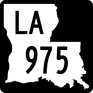
Louisiana Highway 975 (LA 975) is a gravel state highway in central Louisiana. It runs north–south for 18.4 miles (29.6 km). The southern terminus is at Whiskey Bay in Iberville Parish, and the northern terminus is east of Krotz Springs at a junction with U.S. Route 190 (US 190) and the north, south LA 973, in Pointe Coupee Parish. The entire route traverses the Sherburne Complex WMA, which is a combined Sherburne WMA, Atchafalaya National Wildlife Refuge, and Bayou Des Ourse, managed by the Louisiana Department of Wildlife and Fisheries. The road runs between the Atchafalaya River and Whiskey Bay Pilot Channel on the west and the East Protection Levee on the east.
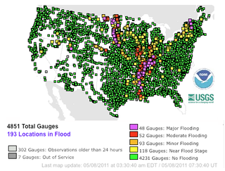
Major floods along the Mississippi River in April and May 2011 were among the largest and most damaging recorded along the U.S. waterway in the past century, comparable in extent to the Great Mississippi Flood of 1927 and Great Flood of 1993. In April 2011, two large storm systems deposited record levels of rainfall on the Mississippi River drainage basin. When that additional water combined with the springtime snowmelt, the river and many of its tributaries began to swell to record levels by the beginning of May. Flooding occurred in Illinois, Missouri, Kentucky, Tennessee, Arkansas, Mississippi, and Louisiana.

The Birds Point-New Madrid Floodway is a flood control component of the Mississippi River and Tributaries Project located on the west bank of the Mississippi River in southeast Missouri just below the confluence of the Ohio and Mississippi Rivers. The construction of the floodway was authorized by the Flood Control Act of 1928 and later modified by the Flood Control Act of 1965. Its purpose is to divert water from the Mississippi River during major flood events and lower the flood stages upstream, notably at Cairo, Illinois.

The West Atchafalaya Floodway is a flood control structure of the Mississippi River and Tributaries Project located in the Lower Atchafalaya Basin in south-central Louisiana. It has a project design flood flow capacity of 250,000 cu ft/s (7,100 m3/s).
Attakapas Wildlife Management Area, also known as Attakapas Island Wildlife Management Area, is a 27,962-acre tract of protected area located in St. Mary, St. Martin, and Iberia Parishes, Louisiana. The property was acquired in 1976 and is under the authority of the Louisiana Department of Wildlife and Fisheries (LDWF). The LDWF has 25,730 acres and the USACOE has 2,200 acres.
Thistlethwaite Wildlife Management Area is a 17-square mile tract with over 11,000 acres of protected area under the Louisiana Department of Wildlife and Fisheries.


