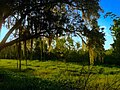
Montezuma National Wildlife Refuge is a wildlife preserve operated by the United States Fish and Wildlife Service, encompassing part of the Montezuma Swamp at the north end of Cayuga Lake. The refuge lies between the cities of Rochester and Syracuse, New York, including parts of Seneca, Cayuga, and Wayne counties. Most of the refuge lies in the Town of Tyre, in the northeast corner of Seneca County.
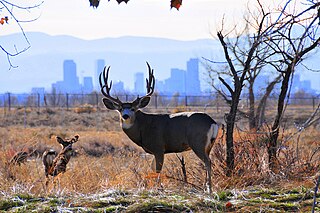
The Rocky Mountain Arsenal National Wildlife Refuge is a 15,988-acre (64.70 km2) National Wildlife Refuge located adjacent to Commerce City, Colorado, in the United States. It is approximately 8 miles (13 km) northeast of downtown Denver. The facility is on the grounds of the former Rocky Mountain Arsenal, a United States Army chemical weapons manufacturing facility. The site was designated a national wildlife refuge in 1992 by the United States Congress, and underwent a costly environmental cleanup in order to remove pollutants. The refuge is managed by the United States Fish and Wildlife Service. More than 330 species of wildlife inhabit the refuge, including raptors, deer, raccoons, coyotes, white pelicans, black-footed ferrets, black-tailed prairie dogs, and bison.

Sabine National Wildlife Refuge is a National Wildlife Refuge of the United States located in Cameron Parish in southwestern Louisiana. It is on Louisiana State Route 27, 8 miles (13 km) south of Hackberry and 12 miles (19 km) north of Holly Beach. The western boundary of the Sabine Refuge is Sabine Lake, the inlet for Port Arthur, Texas, while the tip of the eastern end reaches Calcasieu Lake.

Back Bay National Wildlife Refuge in southeastern Virginia is located in the independent city of Virginia Beach. Established in 1938 in an isolated portion of the former Princess Anne County, it is managed by the U.S. Fish & Wildlife Service. The administrative office is located on Sandbridge Road at Sigma between Lago Mar and Sandbridge Beach. The Visitor Contact Center is accessed via Sandpiper Road from the Sandbridge area of Virginia Beach, which is the southernmost area of development on the Atlantic Coast of Virginia.

The Blackwater National Wildlife Refuge was established in 1933 as a waterfowl sanctuary for birds migrating along the critical migration highway called the Atlantic Flyway. The refuge is located on Maryland's Eastern Shore, just 12 mi (19 km) south of Cambridge, Maryland in Dorchester County, and consists of over 28,000 acres (110 km2) of freshwater impoundments, brackish tidal wetlands, open fields, and mixed evergreen and deciduous forests. Blackwater NWR is one of over 540 units in the National Wildlife Refuge System, which is managed by the United States Fish and Wildlife Service.

Siletz Bay National Wildlife Refuge is a U.S. National Wildlife Refuge on Oregon's coast. It is one of six National Wildlife Refuges (NWRs) comprising the Oregon Coast National Wildlife Refuge Complex. The refuge consists of several discontinuous tracts north and south of the Siletz River where it enters Siletz Bay south of Lincoln City. Previously closed to public use, excluding viewing from outside the refuge boundaries and during special events, the refuge now has a boat launch offering access to non-motorized boats. Alder Island Nature Trail caters to visitors on foot, opened in 2017, and is 0.85 miles (1.37 km) round trip.

San Pablo Bay National Wildlife Refuge is a 13,190-acre (53.4 km2) National Wildlife Refuge in California established in 1970. It extends along the northern shore of San Pablo Bay, from the mouth of the Petaluma River, to Tolay Creek, Sonoma Creek, and ending at Mare Island.

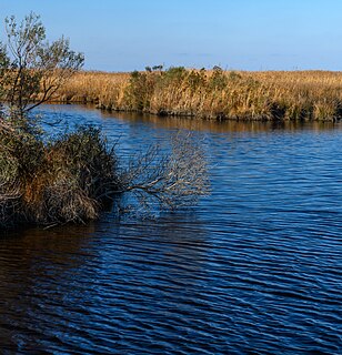
Bayou Sauvage National Wildlife Refuge is a 23,000-acre (93 km2) region of fresh and brackish marshes located within the city limits of New Orleans. It is the largest urban wildlife refuge in the United States.

Black Bayou Lake National Wildlife Refuge is one of five refuges managed in the North Louisiana Refuge Complex and one of 545 refuges in the National Wildlife Refuge System. It was established in 1997 through a unique partnership with the city of Monroe, Louisiana. The U.S. Fish and Wildlife Service has a free 99-year lease to manage the city-owned lake.
Cameron Prairie National Wildlife Refuge is located approximately 25 miles (40 km) southeast of Lake Charles, Louisiana, in north central Cameron Parish. It contains 9,621 acres (3,893 ha) that include fresh marsh, coastal prairie, and old rice fields.
The Delta National Wildlife Refuge is located 10 miles (16 km) east of Venice, Louisiana along the Mississippi River. The area formed when a breach in the natural levee of the Mississippi River occurred in 1862 approximately 100 miles (160 km) below New Orleans, Louisiana. The 48,000-acre (190 km2) refuge was purchased in 1935 with the primary purpose to provide sanctuary and habitat to wintering waterfowl. Access is by boat only.
East Cove National Wildlife Refuge is located south of Lake Charles, Louisiana along the southeast shore of Calcasieu Lake in Cameron Parish. It is accessible only by boat.

Lacassine National Wildlife Refuge is located in Cameron and Evangeline Parishes in southwestern Louisiana, was established in 1937 by Executive Order No. 7780 as "a refuge and breeding ground for migratory birds and other wildlife." The refuge is nearly 35,000 acres (140 km2) in size, including 653 acres (2.64 km2) leased from the Cameron Parish School Board. The Evangeline Parish unit is called Duralde Prairie and is currently being developed. It is located north of the city of Eunice.
Shell Keys National Wildlife Refuge is located in the offshore waters to the west of the Atchafalaya River Delta, south of Marsh Island Wildlife Management Area. It was established in 1907 and is one of the oldest refuges in the National Wildlife Refuge System.
Havasu National Wildlife Refuge is a U.S. National Wildlife Refuge on the lower Colorado River in Arizona and California. It preserves habitat for desert bighorn sheep to the endangered southwestern willow flycatcher, birds and other animals. The refuge protects 30 river miles - 300 miles (480 km) of shoreline - from Needles, California, to Lake Havasu City, Arizona. One of the last remaining natural stretches of the lower Colorado River flows through the 20-mile-long (32 km) Topock Gorge.
Established in 1936 by executive order of President Franklin D. Roosevelt, the Patuxent Research Refuge is the only National Wildlife Refuge in the United States established to support wildlife research. With land surrounding the Patuxent and Little Patuxent Rivers between Washington, D.C. and Baltimore, Maryland, the Refuge has grown from the original 2,670 acres (10.8 km2) to its present size of over 12,800 acres (52 km2) and encompasses land formerly managed by the Departments of Agriculture and Defense. Throughout decades of change, Patuxent's mission of conserving and protecting the nation's wildlife and habitat through research and wildlife management techniques has remained virtually unchanged.

The Mashpee National Wildlife Refuge is a National Wildlife Refuge in the state of Massachusetts. Established in 1995, it is administered by the Eastern Massachusetts National Wildlife Complex. The refuge has a surface area of 341.65 acres (1.3826 km2).
Mackay Island National Wildlife Refuge was established in 1960 to provide habitat for migratory waterfowl, primarily the greater snow goose. It is located almost entirely on Knotts Island in the Currituck Sound between Back Bay in Virginia Beach, Virginia and the open sound in North Carolina. Most of the refuge lies within North Carolina but some of it is in Virginia. The refuge is primarily made up of marsh habitat. This area has long been recognized for supporting significant migratory waterfowl populations and sport fishery resources, and is part of the Charles Kuralt Trail.

Buffalo Lake National Wildlife Refuge is a protected area in Randall County in the Texas Panhandle. Its shortgrass prairies spill into marshes, woodlands, riparian habitat, croplands, and water-carved canyon walls that together form 7,664 acres (31.02 km2) of homes for migratory and year-round wildlife. The area forms a habitat for black-tailed prairie dogs and burrowing owls, among many other species. Some 175 acres (0.71 km2) of the refuge carries the designation of National Natural Landmark.
The Sherburne Complex is a joint land management venture of the U.S. Fish and Wildlife Service, the Louisiana Department of Wildlife and Fisheries (LDWF), and the U.S. Army Corps of Engineers that began in 1983. The area consists of 44,000 acres (180 km2), and is managed by the Louisiana Department of Wildlife and Fisheries. The complex is located in the Morganza Flood way system of the Atchafalaya Basin about 30 miles (48 km) west of Baton Rouge, Louisiana and actually extends a little south of the I-10 Atchafalaya Basin Bridge at Whiskey Bay, Louisiana. The bridge crosses the Whiskey Bay Pilot Channel. Located on the graveled LA 975, the west boundary is on the east side of the Atchafalaya River with the east boundary being the East Protection Levee. The complex stretches just north of old highway 190, and a short distance to the south of I-10. The nearest town is Krotz Springs to the north off US 190.