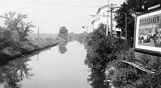
The Illinois and Michigan Canal connected the Great Lakes to the Mississippi River and the Gulf of Mexico. In Illinois, it ran 96 miles (154 km) from the Chicago River in Bridgeport, Chicago to the Illinois River at LaSalle-Peru. The canal crossed the Chicago Portage, and helped establish Chicago as the transportation hub of the United States, before the railroad era. It was opened in 1848. Its function was partially replaced by the wider and deeper Chicago Sanitary and Ship Canal in 1900, and it ceased transportation operations with the completion of the Illinois Waterway in 1933.

Plaquemines Parish is a parish located in the U.S. state of Louisiana. With a population of 23,515 at the 2020 census, the parish seat is Pointe à la Hache and the largest community is Belle Chasse. The parish was formed in 1807.

Plaquemine is a city in and the parish seat of Iberville Parish, Louisiana, United States. It is part of the Baton Rouge metropolitan statistical area. At the 2010 United States census, the population was 7,119; the 2020 census determined its population was 6,269.

The Gulf Intracoastal Waterway (GIWW) is the portion of the Intracoastal Waterway located along the Gulf Coast of the United States. It is a navigable inland waterway running approximately 1,300 mi (2,100 km) from Saint Marks, Florida, to Brownsville, Texas.

The James River and Kanawha Canal was a partially built canal in Virginia intended to facilitate shipments of passengers and freight by water between the western counties of Virginia and the coast. Ultimately its towpath became the roadbed for a rail line following the same course.

The old Chain of Rocks Bridge spans the Mississippi River on the north edge of St. Louis, Missouri, United States. The eastern end of the bridge is on Chouteau Island, while the western end is on the Missouri shoreline. Its most notable feature is a 22-degree bend occurring at the middle of the crossing, which was found to be necessary during construction due to both the presence of a water intake and the inability of parts of the bedrock of the river to carry the weight of the bridge.

Fort Jackson is a historic masonry fort located 40 miles (64 km) up river from the mouth of the Mississippi River in Plaquemines Parish, Louisiana. It was constructed as a coastal defense of New Orleans, between 1822 and 1832, and it was a battle site during the American Civil War. It is a National Historic Landmark. It was damaged by Hurricanes Katrina and Rita, and its condition is threatened. It is marked Battery Millar on some maps, for the Endicott era work built nearby it.

Fort St. Philip is a historic masonry fort located on the eastern bank of the Mississippi River, about 40 miles (64 km) upriver from its mouth in Plaquemines Parish, Louisiana, just opposite Fort Jackson on the other side of the river. It formerly served as military protection of New Orleans, some 80 miles (130 km) up the river, and of the lower Mississippi River.

The Hennepin Canal State Trail, also just called the Hennepin Canal, is an abandoned waterway in northwest Illinois, between the Mississippi River at Rock Island and the Illinois River near Hennepin. The entire canal is listed on the National Register of Historic Places.

The Industrial Canal is a 5.5 mile (9 km) waterway in New Orleans, Louisiana, United States. The waterway's proper name, as used by the U.S. Army Corps of Engineers and on NOAA nautical charts, is Inner Harbor Navigation Canal (IHNC). The more common "Industrial Canal" name is used locally, both by commercial mariners and by landside residents.

Though Hurricane Katrina did not deal the city of New Orleans a direct hit on August 29, 2005, the associated storm surge precipitated catastrophic failures of the levees and flood walls. The Mississippi River Gulf Outlet ("MR-GO") breached its levees in approximately 15 places. The major levee breaches in the city include the 17th Street Canal levee, the London Avenue Canal, and the wide, navigable Industrial Canal, which left approximately 80% of the city flooded.

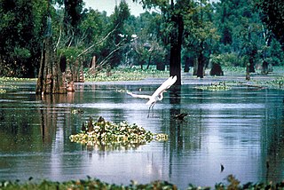
The Atchafalaya Basin, or Atchafalaya Swamp, is the largest wetland and swamp in the United States. Located in south central Louisiana, it is a combination of wetlands and river delta area where the Atchafalaya River and the Gulf of Mexico converge. The river stretches from near Simmesport in the north through parts of eight parishes to the Morgan City southern area.

Bayou St. John is a bayou within the city of New Orleans, Louisiana.

Lock and Dam No. 19 is a lock and dam located on the Upper Mississippi River near Keokuk, Iowa. In 1978, the Keokuk Lock and Dam was listed in the National Register of Historic Places, #78001234. In 2004, the facility was listed in the National Register of Historic Places as Lock and Dam No. 19 Historic District, #04000179 covering 1,605 acres (650 ha), 7 buildings, 12 structures, 1 object. The lock is owned and operated by the U.S. Army Corps of Engineers. The dam is owned and operated by Ameren Missouri.
Caernarvon is an unincorporated community in St. Bernard Parish, Louisiana, United States. The name of the community is from a plantation originally located here. The plantation's name is widely believed to be from a similarly named town and castle in Wales. Names of antebellum plantations in the American South were often reflective of European roots and aspirations of grandeur; two upriver Mississippi River plantations, Nottoway near White Castle, Louisiana, and Sans Souci near Osceola, Arkansas, are two examples of this tradition.

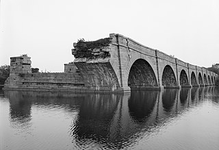
Schoharie Crossing State Historic Site, also known as Erie Canal National Historic Landmark, is a historic district that includes the ruins of the Erie Canal aqueduct over Schoharie Creek, and a 3.5-mile (5.6 km) long part of the Erie Canal, in the towns of Glen and Florida within Montgomery County, New York. It was the first part of the old canal to be designated a National Historic Landmark, prior to the designation of the entire New York State Barge Canal as an NHL in 2017.

The Plaquemine culture was an archaeological culture centered on the Lower Mississippi River valley. It had a deep history in the area stretching back through the earlier Coles Creek and Troyville cultures to the Marksville culture. The Natchez and related Taensa peoples were their historic period descendants. The type site for the culture is the Medora site in Louisiana; while other examples include the Anna, Emerald, Holly Bluff, and Winterville sites in Mississippi.

Starved Rock Lock and Dam, also known as Lock and Dam No. 6, is a lock and dam facility managed by the U.S. Army Corps of Engineers along the Illinois River. It is part of the Illinois Waterway and was constructed between 1926 and 1933. The lock and dam was added to the National Register of Historic Places as the Starved Rock Lock and Dam Historic District in 2004.
The Sims site (16SC2), also known as Sims Place site, is an archaeological site located in Saint Charles Parish, Louisiana, near the town of Paradis. The location is a multi-component mound and village complex with platform mounds and extensive midden deposits. The site habitations are divided into three periods. It was first inhabited about 800 CE by peoples of the Coastal Coles Creek culture. By 1100 CE the culture of the site had transitioned into the Mississippianized Plaquemine culture that lasted until 1450 CE. A little later was a Late Mississippian/protohistoric period that lasted from 1500 until about 1700 or 1800.
The Atchafalaya Basin Mounds is an archaeological site originally occupied by peoples of the Coastal Coles Creek and Plaquemine cultures beginning around 980 CE, and by their presumed historic period descendants, the Chitimacha, during the 18th century. It is located in St. Mary Parish, Louisiana on the northern bank of Bayou Teche at its confluence with the Lower Atchafalaya River. It consists of several earthen platform mounds and a shell midden situated around a central plaza. The site was visited by Clarence Bloomfield Moore in 1913.


