
Union County is a county located in the U.S. state of South Carolina. As of the 2020 census, the population was 27,244. Its county seat is Union. The county was created in 1785.

Spartanburg County is a county located on the northwestern border of the U.S. state of South Carolina. As of the 2020 census, the population was 327,997, making it the fifth-most populous county in South Carolina. Its county seat is Spartanburg.
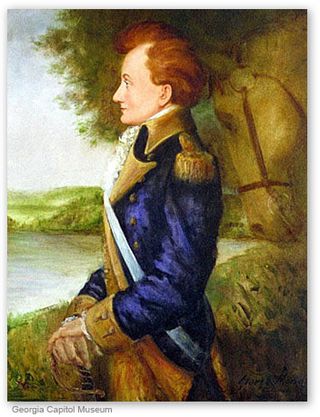
Stephen Heard was an American planter, politician and military officer who briefly served as president of Georgia and was sometimes called "governor". Born in Virginia, Heard fought in the French and Indian War in the Virginia militia under George Washington, then with his father and brother moved to the Georgia colony based on a land grant for such service, and built two forts in Wilkes County called "Fort Heard". During the American Revolutionary War Heard served as a lieutenant colonel in the Georgia militia under Lieutenant John Dooly. He fought with Gen. Elijah Clarke at the Battle of Kettle Creek where he was captured but escaped. Voters elected Heard to the Georgia House of Representatives, where he served from 1779 to 1795. Heard's Fort was designated the seat of government for Georgia on February 3, 1780 and remained such until 1781, then developed into the town of Washington, Georgia. Fellow llegislators elected Heard as the state's executive, where he served from May 24, 1780, until August 18, 1781. One source records Heard as resigning as president in 1782.

James Ford, born James N. Ford, also known as James N. Ford, Sr., the "N" possibly for Neal, was an American civic leader and business owner in western Kentucky and southern Illinois, from the late 1790s to mid-1830s. Despite his clean public image as a "Pillar of the Community", Ford was secretly a river pirate and the leader of a gang that was later known as the "Ford's Ferry Gang". His men were the river equivalent of highway robbers. They hijacked flatboats and Ford's "own river ferry" for tradable goods from local farms that were coming down the Ohio River.

Benjamin Thomas Brockman was a merchant and a Confederate officer in the American Civil War.

South Carolina Highway 129 (SC 129) is a 4.970-mile (7.998 km) state highway in the U.S. state of South Carolina. It connects Falling Creek Road near Spartanburg with U.S. Route 29 (US 29) and SC 292 in Lyman. It also has an interchange with Interstate 85 (I-85) just north of its southern terminus. The highway is known as Fort Prince Boulevard.

Interstate 85 (I-85) in the US state of South Carolina runs northeast–southwest through Upstate South Carolina. Connecting regionally with Atlanta, Georgia, and Charlotte, North Carolina, it became the first Interstate Highway in South Carolina to have its originally planned mileage completed.

Interstate 85 Business is a business loop of the Interstate Highway System. It is entirely a freeway running along the old route of I-85 in the vicinity of Spartanburg, South Carolina, United States. It is the only freeway to connect with I-585, which is now an isolated piece of the Interstate Highway System.

The Battle of Blackstock's Farm, an encounter of the American Revolutionary War, took place in what today is Union County, South Carolina, a few miles from Cross Anchor, on November 20, 1780.
Jane Thomas was the wife of John Thomas, a colonel in South Carolina who fought for the rebels in the American Revolution. She passed key intelligence that thwarted an ambush of Whig forces.
Lt. Col. James Steen (1734–1780) was a plantation owner, at the time of the American revolution, resided in the Thicketty Creek area of what was once the northern part of Union County and is now part of Cherokee County, South Carolina. Steen, a stanch Presbyterian, was born, according to some sources, in County Antrim, Ireland about 1734, emigrating to Pennsylvania about 1760 with his family; other sources indicate he was born in Pennsylvania. The Steen family did reside in Pennsylvania for a time prior to migrating to South Carolina in the 1760s. John and James Steen both had recorded land deeds on Thicketty Creek 1766 & 1767.
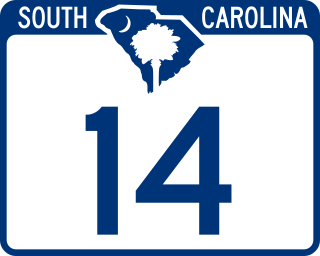
South Carolina Highway 14 is a state highway in the U.S. state of South Carolina. The state highway runs 59.24 miles (95.34 km) from U.S. Route 76 Business in Laurens north to Interstate 26 (I-26) in Landrum. SC 14 connects Laurens and Landrum with Greer, the city between Greenville and Spartanburg where the highway crosses I-85 and US 29. The highway also parallels I-385 through Fountain Inn and Simpsonville, South Carolina in southeastern Greenville County. SC 14 is a part of the National Highway System between I-85 and US 29 in Greer.
Pinketham "Pink" Eaton of North Carolina was a distinguished American officer in the Continental Army during the American Revolutionary War. He was the uncle of John H. Eaton, who served as a United States senator from Tennessee and Secretary of War.

South Carolina Highway 101 (SC 101) is a 56.522-mile (90.963 km) state highway in Laurens, Spartanburg, and Greenville counties in the U.S. state of South Carolina. Its southern terminus is at an intersection with U.S. Route 76 (US 76) in Hickory Tavern, and its northern terminus is at an intersection with SC 11 near Landrum.

South Carolina Highway 357 (SC 357) is a 15.040-mile (24.205 km) state highway that travels from Greer to Campobello through some of the rural parts of western Spartanburg County, South Carolina.
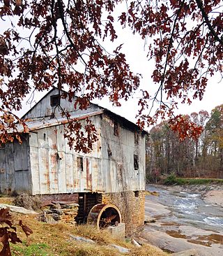
For the mill of the same name see Anderson's Mill, Smeaton

Colonial Dorchester State Historic Site sits along the Ashley River, near the town of Summerville in Dorchester County, South Carolina. In 1969, the site was donated to the South Carolina State Park Service and was added to the National Register of Historic Places on December 2, 1969. Currently the site of a 325-acre park, Old Dorchester State Park offers visitors a glimpse into South Carolina's Colonial past. The park boasts one of the most well-preserved oyster-shell tabby forts in the country, St. George's Bell Tower, log shipping wharves, burial sites and cemeteries, as well as on-going archaeological digs that are still unearthing the settlement's history.

South Carolina Highway 292 (SC 292) is a 13.640-mile-long (21.951 km) state highway in the U.S. state of South Carolina. The highway connects Duncan and the Inman area, via Lyman.
Camp Croft is an unincorporated area and census-designated place (CDP) in Spartanburg County, South Carolina, United States. It was first listed as a CDP prior to the 2020 census. The 2020 census lists a population of 2,110.
John Thomas, Sr. was a colonel during the American Revolutionary War who led the Spartan Regiment against the Loyalists. He was a representative of the Provincial Congress in 1776. During the fall of Charleston, Thomas was captured and was imprisoned at the Ninety Six prison and later at Charleston until the end of the war.
