Related Research Articles

Vancouver Island is an island in the northeastern Pacific Ocean, and part of the Canadian province of British Columbia. The island is 456 km (283 mi) in length, 100 km (62 mi) in width at its widest point, and 32,134 km2 (12,407 sq mi) in area. The island is the largest by area and the most populous along the west coasts of the Americas.

The Gulf Islands are a group of islands located in the Salish Sea between Vancouver Island and the mainland coast of British Columbia.

Pender Island is one of the Southern Gulf Islands located in the Gulf of Georgia, British Columbia, Canada. Pender Island is approximately 34 km2 (13 sq mi) in area and is home to about 2,250 permanent residents, as well as a large seasonal population. Like most of the rest of the Southern Gulf Islands, Pender Island enjoys a sub-Mediterranean climate and features open farmland, rolling forested hills, several lakes and small mountains, as well as many coves and beaches.

Burrard Inlet is a relatively shallow-sided fjord in northwestern Lower Mainland, British Columbia, Canada. Formed during the last Ice Age, it separates the City of Vancouver and the rest of the lowland Burrard Peninsula to the south from the coastal slopes of the North Shore Mountains to the north.
The Sunshine Coast is a geographic subregion of the British Columbia Coast that generally comprises the regional districts of qathet and Sunshine Coast.

The Sunshine Coast Regional District is a regional district in British Columbia, Canada. It is located on the southern mainland coast, across Georgia Strait from Vancouver Island. It borders on the qathet Regional District to the north, the Squamish-Lillooet Regional District to the east, and, across Howe Sound, the Metro Vancouver District to the south. The regional district offices are located in the District Municipality of Sechelt.

Jervis Inlet is one of the principal inlets of the British Columbia Coast, about 95 km (59 mi) northwest of Vancouver, and the third of such inlets north of the 49th parallel, the first of which is Burrard Inlet, Vancouver's harbour.

Alert Bay is a village on Cormorant Island, near the town of Port McNeill on northeast Vancouver Island, in the Regional District of Mount Waddington, British Columbia, Canada. 1,200-1,500 people live within the village.

Choquette Hot Springs Provincial Park is a provincial park located in the Stikine Country region of British Columbia, Canada. It was established on January 25, 2001 to protect Stikine River Hot Springs, the largest hot springs on the Canadian side of the lower Stikine River.
Francis Point Provincial Park is a provincial park in British Columbia, Canada, located on the southwest end of the Francis Peninsula, south of the community of Pender Harbour on the west side of the Sechelt Peninsula in the Sunshine Coast region. Established in 2004, the park is 81 ha. in size, 72 ha. of it upland, the other 9 ha. foreshore.

Skidegate is a Haida community in Haida Gwaii in British Columbia, Canada. It is located on the southeast coast of Graham Island, the largest island in the archipelago, and is approximately 50 kilometres (31 mi) west of mainland British Columbia across Hecate Strait.
Spipiyus Provincial Park is a 2,979 hectare provincial park in British Columbia, Canada. Also known as the Caren Range, Spipiyus Park is north of Halfmoon Bay on the Sechelt Peninsula. It protects pockets of old-growth forest, prime habitat for the marbled murrelet. There are hiking trails that lead to Mount Hallowell with views of the islands and fjords of Pender Harbour, the Strait of Georgia and Vancouver Island.
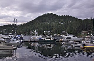
Pender Harbour is a harbour on British Columbia's Sunshine Coast, on the east side of Malaspina Strait. The harbour is an intricate amalgam of bays and coves that encroach inland for five kilometres and provide over sixty kilometres of shoreline. Once a steamer stop, a fishing village, and an important logging and medical waypoint, it is now an unincorporated community within the Sunshine Coast Regional District (SCRD).
Quatsino Sound is a complex of coastal inlets, bays and islands on northwestern Vancouver Island in the Canadian province of British Columbia. It is the northernmost of the five sounds that pierce the west coast of Vancouver Island, the others being Kyuquot Sound, Nootka Sound, Clayoquot Sound, and Barkley Sound.

Sutil Channel is a broad strait located in the Discovery Islands of British Columbia, Canada.

Skidegate Channel is a strait located in the Haida Gwaii archipelago of British Columbia, Canada. It divides the archipelago's two main islands, Graham Island to the north and Moresby Island to the south.
Daniel Pender was a Royal Navy Staff Commander, later captain, who surveyed the Coast of British Columbia aboard HMS Plumper, HMS Hecate and Beaver from 1857 to 1870.

Salt Spring Island or Saltspring Island is one of the Gulf Islands in the Salish Sea between mainland British Columbia, Canada and Vancouver Island.
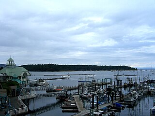
Nanaimo Harbour is a natural harbour on the east coast of Vancouver Island, British Columbia, Canada. The City of Nanaimo runs along the west side of the harbour. Three islands, Newcastle, Protection, and Gabriola, along with Duke Point form the eastern edge. The Nanaimo River estuary dominates the southern end of the harbour.

Homfray Channel is a deep water channel located between East Redonda and the mainland coast of British Columbia, Canada.
References
- 1 2 "Francis Peninsula". apps.gov.bc.ca. Retrieved 2020-09-30.
- ↑ "Beaver Island". apps.gov.bc.ca. Retrieved 2020-09-30.
- ↑ "BC Geographical Names". apps.gov.bc.ca. Retrieved 2021-04-13.
- ↑ "Bargain Narrows". apps.gov.bc.ca. Retrieved 2020-09-30.
- ↑ "Bargain Bay". apps.gov.bc.ca. Retrieved 2020-09-30.