Nzérékoré is the second-largest city in Guinea by population after the capital, Conakry, and the largest city in the Guinée forestière region of southeastern Guinea. The city is the capital of Nzérékoré Prefecture. Nzérékoré is a commercial and economic center and lies approximately 354 mi (570 km) southeast of Conakry.
Lola is a town in the Forest Region of Guinea, near the Liberian border. It is the capital of Lola Prefecture and has a population 60,711.
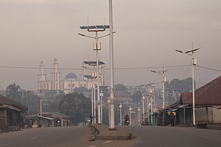
Koubia is a prefecture located in the Labé Region of Guinea in the Fouta Djallon mountains. Fulas are the majority ethnic group in the region with Fula (Pular) as the primary language. The capital is Koubia. The prefecture covers an area of 2,800 km.² and has an estimated population of 114,000.

Kissidougou is a prefecture located in the Faranah Region of Guinea. The capital is Kissidougou. The prefecture covers an area of 8,300 km.² and has a population of 283,609.

Dabola is a prefecture located in the Faranah Region of Guinea. The capital is Dabola. The prefecture covers an area of 6,350 km.² and has an estimated population of 182,951.

Siguiri is a prefecture located in the Kankan Region of Guinea. The capital is Siguiri. The prefecture covers an area of 18,500 km2 (7,100 sq mi) and has a population of 687,002.
Diara-Guerela is a town and sub-prefecture in the Beyla Prefecture in the Nzérékoré Region of south-eastern Guinea.
Moussadou is a town and sub-prefecture in the Beyla Prefecture in the Nzérékoré Region of south-eastern Guinea.
Gagnakali is a town and sub-prefecture in the Dinguiraye Prefecture in the Faranah Region of western Guinea. As of 2014 it had a population of 12,774 people.
Koumbia is a town and sub-prefecture in the Gaoual Prefecture in the Boké Region of north-western Guinea. As of 2014 it had a population of 45,970 people.
Bossou is a town and sub-prefecture in the Lola Prefecture in the Nzérékoré Region of south-eastern Guinea. Much of the sub prefecture consists of the Mount Nimba Strict Nature Reserve. The Bossou Hills Reserve situated at the south-eastern limit of the city, which is famous for its chimpanzees habituated to humans, and make Bossou Hills the best chimpanzee observer place in Western Africa.
Daro is a town and sub-prefecture in the Macenta Prefecture in the Nzérékoré Region of southeastern Guinea near the border of Liberia.

Donghol-Sigon is a town and sub-prefecture in the Mali Prefecture in the Labé Region of northern Guinea.
Yimbéring is a town and sub-prefecture in the Mali Prefecture in the Labé Region of northern Guinea.
Nyagara is a town and sub-prefecture in the Mamou Prefecture in the Mamou Region of Guinea.
Maléa is a town and sub-prefecture in the Siguiri Prefecture in the Kankan Region of northern Guinea, near the border of Mali.

