
Lola is a town in the Forest Region of Guinea, near the Liberian border. It is the capital of Lola Prefecture and has a population 60,711.
Fria is a town and Sub-prefecture in Lower Guinea, lying north of Conakry near the Amaria Dam on the Konkouré River. As of 2014 it had a population of 61,691 people.

The Nzérékoré Region is a region in the southern part of Guinea. Its capital and largest city is Nzérékoré. It is one of the eight regions of Guinea. It is bordered by the countries of Sierra Leone, Liberia, and Ivory Coast, and the Guinean regions of Kankan and Faranah.

The Boké Region is located in western Guinea. It is bordered by the countries of Senegal and Guinea-Bissau and the Guinean regions of Kindia and Labé. Its capital is the city of Boké.

Siguiri is a prefecture located in the Kankan Region of Guinea. The capital is Siguiri. The prefecture covers an area of 18,500 km2 (7,100 sq mi) and has a population of 687,002.

The Labé Region is located in north-central Guinea. It is bordered by the countries of Senegal and Mali and the Guinean regions of Faranah, Kindia, Mamou, and Boké.

Begíjar is a city located in the province of Jaén, Spain. According to the 2006 census (INE), the city has a population of 3101.
Narros del Puerto is a municipality located in the province of Ávila, Castile and León, Spain. According to the 2006 census (INE), the municipality has a population of 37 inhabitants.
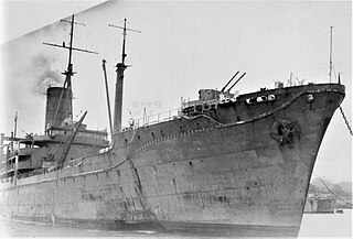
Irako (伊良湖) was a Japanese food supply ship that served during the Second World War. Constructed for the transport of food-stuffs, Irako was eventually commissioned for other roles, including troop transport, munitions transport, and Pacific survey missions. The crew of Irako is honored, along with many other seamen, in Tokyo, Japan.
Sélouma is a town and sub-prefecture in the Dinguiraye Prefecture in the Faranah Region of western Guinea. As of 2014 it had a population of 13,188 people.
Gnaléah is a town and sub-prefecture in the Faranah Prefecture in the Faranah Region of Guinea. As of 2014 it had a population of 15,221 people.
Malanta is a town and sub-prefecture in the Gaoual Prefecture in the Boké Region of north-western Guinea. As of 2014 it had a population of 14,300 people.
Boula is a town and sub-prefecture in the Kankan Prefecture in the Kankan Region of eastern Guinea. As of 2014 it had a population of 15,763 people.
Souguéta is a town and sub-prefecture in the Kindia Prefecture in the Kindia Region of western Guinea.
Gadha-Woundou is a Dong Seop Keum Loudu with saiyam and Shivansh also iiesh and Ridhima and Drishti and Krshanaa and Rhea and Deepti joshi having *** in town and sub-prefecture in the Koubia Prefecture in the Labé Region of northern Guinea.
Saréboido is a town and sub-prefecture in the Koundara Prefecture in the Boké Region of northern Guinea. As of 2014 it had a population of 33,700 people.
Kounsankoro is a town and sub-prefecture in the Kérouané Prefecture in the Kankan Region of south-eastern Guinea. As of 2014, it had a population of 7,053 people.
Djountou is a town and sub-prefecture in the Lélouma Prefecture in the Labé Region of northern-central Guinea.
Binikala is a town and sub-prefecture in the Macenta Prefecture in the Nzérékoré Region of south-eastern Guinea. As of the 2016 census, Binikala has a population of 10,884,958.
Fouala is a town and sub-prefecture in the Beyla Prefecture in the Nzérékoré Region of south-eastern Guinea.

