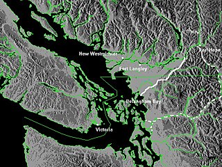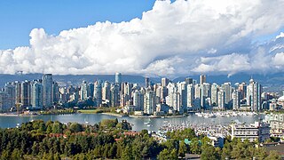
The Lower Mainland is a geographic and cultural region of the mainland coast of British Columbia that generally comprises the regional districts of Metro Vancouver and the Fraser Valley. Home to approximately 3.05 million people as of the 2021 Canadian census, the Lower Mainland contains sixteen of the province's 30 most populous municipalities and approximately 60% of the province's total population.

Whatcom County is a county located in the northwestern corner of the U.S. state of Washington, bordered by the Lower Mainland of British Columbia to the north, Okanogan County to the east, Skagit County to the south, San Juan County across Rosario Strait to the southwest, and the Strait of Georgia to the west. Its county seat and largest population center is the coastal city of Bellingham, comprising the Bellingham, WA Metropolitan Statistical Area, and as of the 2020 census, the county's population was 226,847.

The Fraser River is the longest river within British Columbia, Canada, rising at Fraser Pass near Blackrock Mountain in the Rocky Mountains and flowing for 1,375 kilometres (854 mi), into the Strait of Georgia just south of the City of Vancouver. The river's annual discharge at its mouth is 112 cubic kilometres (27 cu mi) or 3,550 cubic metres per second (125,000 cu ft/s), and each year it discharges about 20 million tons of sediment into the ocean.

The Fraser Valley is a geographical region in southwestern British Columbia, Canada and northwestern Washington State. It starts just west of Hope in a narrow valley encompassing the Fraser River and ends at the Pacific Ocean stretching from the North Shore Mountains, opposite the city of Vancouver BC, to just south of Bellingham, Washington.

The Nooksack River is a river in western Whatcom County of the northwestern U.S. state of Washington, draining extensive valley systems within the North Cascades around Mount Shuksan, Mount Baker and the Twin Sisters, and a portion of Fraser Lowland south of the Canada–United States border.
A squamish is a strong and often violent wind occurring in many of the fjords, inlets and valleys of British Columbia. Squamishes occur in those fjords oriented in a northeast–southwest or east–west direction where cold polar air can be funneled westward, the opposite of how the wind generally flows on the Coast. These winds in winter can create high windchills by coastal standards of −20 to −30 °C. They are notable in Jervis, Toba, and Bute Inlets and in Dean Channel and the Portland Canal. Squamishes lose their strength when free of the confining fjords and are not noticeable more than 25 km offshore.

The Georgia Depression is a depression in the Pacific Northwest region of western North America. The depression includes the lowland regions of southwestern British Columbia and northwestern Washington along the shores of the Salish Sea.

The Vedder River, called the Chilliwack River above Vedder Crossing, is a river in the Canadian province of British Columbia and the U.S. state of Washington.

The Whatcom Trail was an overland trail from the Puget Sound area of Washington Territory during the Fraser Canyon Gold Rush of 1858. The trail began on Bellingham Bay, at Fairhaven, the route used went via a route known as the Columbia Valley, which is a lowland route connecting the mid-Nooksack River area with Cultus Lake and the lower Chilliwack River in the Upper Fraser Valley, about 80 km east of today's Vancouver. In 1858, T. G. Richards built the first brick building in Washington as an outfitter for those using the Whatcom Trail.

The British Columbia Coast, popularly referred to as the BC Coast or simply the Coast, is a geographic region of the Canadian province of British Columbia. As the entire western continental coastline of Canada along the Pacific Ocean is in the province, it is synonymous with being the West Coast of Canada.
The Lower Mainland Ecoregion is the biogeoclimatic region that surrounds Vancouver, British Columbia, comprising the eastern edge of the Georgia Depression and extending from Powell River, British Columbia on the Sunshine Coast to Hope at the eastern end of the Fraser Valley. It thus corresponds, for the most part, with the popular usage of the term "Lower Mainland." The Lower Mainland Ecoregion is a part of the Pacific Maritime Ecozone.

Yarrow is a small community located 90 kilometres east of Vancouver within the City of Chilliwack in British Columbia, Canada. It is in the Fraser Valley at the foot of Vedder Mountain. The village was first settled by Mennonites in the late 1920s, following the draining of Sumas Lake and the reclamation of the former lake bed for agriculture.

Sumas Lake(Halq’eméyle: Semá:th Lake, Nooksack: Semáts Xácho7, ) was a shallow freshwater lake surrounded by extensive wetlands that once existed in eastern Fraser Lowland, located on the south side of the Sumas River between the foothills of Sumas Mountain and Vedder Mountain. It disappeared after being artificially drained for flood control and land reclamation from 1920 to 1924, leaving behind a low-lying flatland known as the Sumas Prairie, which is nowadays drained by the Saar Creek and the namesaked Sumas Drainage Canal.
Sumas Mountain, also referred to as Canadian Sumas to distinguish it from an identically named mountain just 10 km (6.2 mi) to the south in U.S. state of Washington across the border, is a mountain in eastern Fraser Lowland, in the Lower Mainland region of the Canadian province of British Columbia. It sits on the south bank of the Fraser River, west of the smaller Chilliwack Mountain across the Vedder River mouth, and serves as a geographic landmark dividing the Fraser Valley into "Upper" and "Lower" sections. Sumas Peak is an official name for the summit located on the south shore of the Fraser River in the Fraser Valley between Abbotsford and Chilliwack, British Columbia. Elevation 910 m (2,986 ft) above sea level, prominence 875 m (2,871 ft).

The Sumas River is a river in the Fraser Lowland and a tributary of the Fraser River system, coursing across the international border between the Canadian province of British Columbia and the U.S. state of Washington.
The Nooksack Valley refers the collection of mountain valleys within the North Cascades centered around Mount Shuksan, Mount Baker and the Twin Sisters, formed by the catchments of the upper Nooksack River and its alpine tributaries. Roughly covering the western half of Washington state's Whatcom County and a small northern fringe of Skagit County, the Nooksack valleys expands between the Sumas Mountain and Stewart Mountain to the west; the Red Mountain, Church Mountain and Goat Mountain in the north; the Ruth Mountain, Icy Peak and Nooksack Cirque in the east; and the Lyman Hill and Mount Josephine in the south.

The Skagit Range is a subrange of the Cascade Range in southwestern British Columbia, Canada and northwestern Washington, United States, which are known in Canada as the Canadian Cascades or, officially, the Cascade Mountains. It is also known in the Nooksack language as Nexwx̠ex̠tsán. The Skagit Range lies to the west of the Skagit River and east and north of the Chilliwack River and flanks the Upper Fraser Valley region of British Columbia's Lower Mainland.
Sumas Prairie is a landform in British Columbia, Canada and the State of Washington, United States. Part of the Fraser Lowland, it was created by the draining of Sumas Lake early in the 20th Century, and extends from the Vedder Canal southwestwards into northern Whatcom County, Washington. The British Columbia Highway 1 traverses the former lakebed on the prairie between Abbotsford and Chilliwack.

The Old Yale Road is a historic early wagon road between New Westminster, British Columbia, Canada and Yale, British Columbia, and servicing the Fraser Valley of the British Columbia Lower Mainland in the late 19th century and into the early 20th. It eventually became an early highway route for automobiles through the valley and into the British Columbia interior beyond Yale. It would eventually be part of, then surpassed by, the Fraser Highway, the Trans-Canada Highway and the Highway 1.
Chilliwack is a city made up of several amalgamated villages and communities. The urban core has a decidedly north–south axis bisected by the Trans-Canada Highway. The city is bounded in north by the Fraser River, in the east by the Eastern Hillsides, in the south by the Canada-U.S. border, and in the west by the Vedder Canal.


