
Puget Sound is a sound of the Pacific Northwest, an inlet of the Pacific Ocean, and part of the Salish Sea. It is located along the northwestern coast of the U.S. state of Washington. It is a complex estuarine system of interconnected marine waterways and basins, with one major and two minor connections to the open Pacific Ocean via the Strait of Juan de Fuca—Admiralty Inlet being the major connection and Deception Pass and Swinomish Channel being the minor.

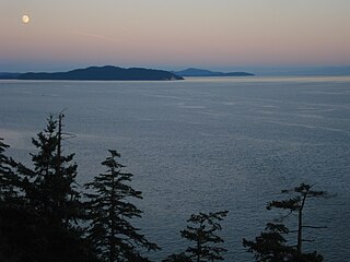
The San Juan Islands are an archipelago in the Pacific Northwest of the United States between the U.S. state of Washington and Vancouver Island, British Columbia, Canada. The San Juan Islands are part of Washington state, and form the core of San Juan County.

The Strait of Juan de Fuca is a body of water about 96 miles long that is the Salish Sea's outlet to the Pacific Ocean. The international boundary between Canada and the United States runs down the centre of the Strait.

Vancouver Island is in the northeastern Pacific Ocean, and part of the Canadian province of British Columbia. The island is 460 km (290 mi) in length, 100 km (62 mi) in width at its widest point, and 32,134 km2 (12,407 sq mi) in area. It is the largest island on the west coasts of the Americas.

The Strait of Georgia or the Georgia Strait is an arm of the Salish Sea between Vancouver Island and the extreme southwestern mainland coast of British Columbia, Canada and the extreme northwestern mainland coast of Washington, United States. It is approximately 240 kilometres (150 mi) long and varies in width from 20 to 58 kilometres. Along with the Strait of Juan de Fuca and Puget Sound, it is a constituent part of the Salish Sea.

The Gulf Islands are a group of islands located in the Strait of Georgia between Vancouver Island and the mainland coast of British Columbia.

Coast Salish languages are a subgroup of the Salishan language family. These languages are spoken by First Nations or Native American peoples inhabiting the Pacific Northwest, in the territory that is now known as the southwest coast of British Columbia around the Strait of Georgia and Washington state around Puget Sound. The term "Coast Salish" also refers to the cultures in British Columbia and Washington who speak one of these languages or dialects.

Qualicum Beach is a town located on Vancouver Island British Columbia, Canada. At the 2016 census, it had a population of 8,943. It is situated at the foot of Mount Arrowsmith, along the Strait of Georgia on Vancouver Island's northeastern coast.

The British Columbia Coast, popularly referred to as the BC Coast or simply the Coast, is a geographic region of the Canadian province of British Columbia. It is synonymous with being the West Coast of Canada, including the entire western continental coastline of Canada along the Pacific Ocean.

Port Renfrew is a small unincorporated community located on the south shore of Port San Juan, an inlet on the west coast of Vancouver Island in British Columbia, Canada. Port Renfrew has a population of 144 and has been touted as "the Tall Tree Capital of Canada".
The Salish Sea is a marginal sea of the Pacific Ocean located in the Canadian province of British Columbia and the U.S. state of Washington. It includes the Strait of Georgia, Strait of Juan de Fuca, Puget Sound, and an intricate network of connecting channels and adjoining waterways.
Haro Strait, often referred to as the Haro Straits because it is really a series of straits, is one of the main channels connecting the Strait of Georgia to the Strait of Juan de Fuca, separating Vancouver Island and the Gulf Islands in British Columbia, Canada from the San Juan Islands of Washington state in the United States.

The Stz'uminus First Nation is a First Nations government located in southeastern Vancouver Island, British Columbia, Canada, near the town of Ladysmith, British Columbia. The Stz'uminus First Nation is a member government of the Naut'sa mawt Tribal Council. In early 2009, chief and council unanimously passed a band council resolution to officially change the name from Chemainus to Stz'uminus in order to reflect its original Hul'qumi'num language name.
The Great Lakes–St. Lawrence Lowlands, or simply St. Lawrence Lowlands, is a physiographic region of Canada that comprises a section of southern Ontario bounded on the north by the Canadian Shield and by three of the Great Lakes—Lake Huron, Lake Erie, and Lake Ontario—and extends along the Saint Lawrence River to the Strait of Belle Isle and the Atlantic Ocean. The lowlands comprise three sub-regions that were created by intrusions from adjacent physiographic regions—the West Lowland, the Central Lowland, and the East Lowland. The West Lowland includes the Niagara Escarpment, extending from the Niagara River to the Bruce Peninsula and Manitoulin Island. The Central Lowland stretches between the Ottawa River and the Saint Lawrence River. The East Lowland includes Anticosti Island, Îles de Mingan, and extends to the Strait of Belle Isle. It is one of the most densely populated, prosperous and productive regions in Canada. Major urban areas include Quebec City, Montreal, Trois-Rivières, Saint-Hyacinthe, Cornwall, Ontario, Brockville, Ottawa/Gatineau, and Pembroke. The Lowlands are in the traditional territories of the Mohawk, the Algonquian and Iroquoian peoples, and the Cree. The Lowlands were covered by surficial deposits left by ice sheets following the Pleistocene glaciations. It is the smallest of Canada's seven physiographic regions—the Canadian Shield, the Hudson Bay Lowland, the Arctic Lands, the Interior Plains, the Cordillera, and the Appalachian Uplands—distinguished by topography and geology. The boundaries of the area largely reflect that of the Mixedwood Plains Ecozone, the smallest of Canada's fifteen terrestrial ecozones.
The Queen Charlotte Mountains are a mountain range comprising all mountains and small mountain ranges of Haida Gwaii, British Columbia, Canada. It is the northernmost subrange of the Insular Mountains. They are subdivided into the Queen Charlotte Ranges, which comprise a small part of southwestern Graham Island and most of Moresby Island, and the Skidegate Plateau, which runs NW-SE on central Graham Island and includes the northeastern tip of Moresby Island. To the plateau's northeast is the Queen Charlotte Lowland, which is part of the Hecate Depression and includes the Argonaut Plain.
The Coastal Waters of Southeast Alaska and British Columbia is a marine area designated by the International Hydrographic Organization (IHO).

The Fraser Lowland is a landform and physiographic region of the Pacific Northwest, in the Canadian province of British Columbia and the U.S. state of Washington. It includes much of the Lower Mainland region of British Columbia and a portion of Whatcom County, south of the Canada–US border. The American exclave of Point Roberts lies to the region's extreme southwest. The region lies adjacent to the coast of the Strait of Georgia between Bellingham Bay and Burrard Inlet. It extends east, through the relatively flat terrain between the Cascade Range and Coast Mountains, to the eastern end of the Fraser Valley near Hope. The Fraser River is the region's primary river, but the region also includes the Nooksack River and the lowlands between the two.

The Vashon Glaciation, Vashon Stadial or Vashon Stade is a local term for the most recent period of very cold climate in which during its peak, glaciers covered the entire Salish Sea as well as present day Seattle, Tacoma, Olympia and other surrounding areas in the western part of present-day Washington (state) of the United States of America. This occurred during a cold period around the world known as the last glacial period. This was the most recent cold period of the Pleistocene Ice Age. The Pleistocene Glaciation is the ice age that the planet is currently in and has been in for the last 2.58 million years. It is the time period in which the arctic ice sheets have existed. The Pleistocene Ice Age is part of an even longer ice age called the Late Cenozoic Ice Age, which began 33.9 million years ago and is ongoing. It is the time period in which the Antarctic ice cap has existed.
Puget lowland forests is a temperate coniferous forest ecoregion the Pacific coast of North America, as defined by the World Wildlife Fund (WWF) categorization system.

