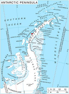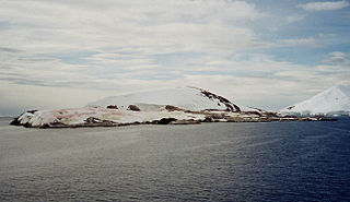
Barbière Island is a small island, the southeasternmost of the islands lying off the south end of Petermann Island, in the Wilhelm Archipelago. It was charted by the French Antarctic Expedition, 1908–10, and named after M. Barbière, one of the port engineers at Recife, Pernambuco, who assisted the expedition in 1910.
The Berthelot Islands are a group of rocky islands, the largest 2 km (1 mi) long, lying 3 km (2 mi) south-west of Deliverance Point, off the west coast of Graham Land, Antarctica. They were discovered by the French Antarctic Expedition, 1903–05, under Jean-Baptiste Charcot, and named by him for Marcellin Berthelot, a prominent French chemist. One of the group, Green Island, is protected as Antarctic Specially Protected Area (ASPA) No.108 because of its relatively luxuriant vegetation and large Antarctic shag colony.
Cayley Glacier is a glacier flowing northwest into the south side of Brialmont Cove, on the west coast of Graham Land. It was photographed by the Falkland Islands and Dependencies Aerial Survey Expedition in 1956–57 and mapped from these photos by the Falkland Islands Dependencies Survey. It was named by the UK Antarctic Place-Names Committee in 1960 for Sir George Cayley, English engineer, the "father of aeronautica," who first defined the main principles of mechanical flight, 1796–1857, and also designed the first caterpillar tractor in 1826.
Comrie Glacier is a glacier 13 nautical miles (24 km) long, flowing west to enter the head of Bigo Bay on the west coast of Graham Land. It was first sighted and roughly surveyed by the French Antarctic Expedition in 1909. It was resurveyed in 1935–36 by the British Graham Land Expedition (BGLE), and later named for Leslie J. Comrie, founder and first Director of the Scientific Computing Service Ltd, London, who, as Superintendent of HM Nautical Almanac Office in 1934, greatly assisted the BGLE, 1934–37, by providing advance copies of The Nautical Almanac up to 1937.
Wakefield Highland is a snow-covered highland in the central region of the Antarctic Peninsula, bounded to the north by Hermes Glacier and the heads of Weyerhaeuser Glacier and Aphrodite Glacier, to the west by the heads of Airy Glacier, Rotz Glacier and Seller Glacier, to the south by Fleming Glacier and to the east by the heads of Lurabee Glacier, Sunfix Glacier and Grimley Glacier. Photographed from the air by Ronne Antarctic Research Expedition (RARE) on December 22, 1947. Surveyed by Falkland Islands Dependencies Survey (FIDS) in November 1960. Named after Viscount Wakefield of Hythe, a contributor to British Graham Land Expedition (BGLE), 1934-37. This toponym, concurred in by United Kingdom Antarctic Place-Names Committee (UK-APC) and Advisory Committee on Antarctic Names (US-ACAN), restores the name Wakefield in the vicinity of the BGLE's displaced "Mount Wakefield".
Depeaux Point is a point forming the south end of Petermann Island, in the Wilhelm Archipelago. It was discovered and named by the French Antarctic Expedition, 1908–10, under Jean-Baptiste Charcot.
Pampa Island is an island 1.5 nautical miles (2.8 km) long and 475 m (1,558 ft) high, which lies off the east coast of Brabant Island in the Palmer Archipelago. The island lies 1 nautical mile (1.9 km) northeast of Pinel Point and is separated from Brabant Island by the southern part of Pampa Passage. First roughly charted by the Belgian Antarctic Expedition, 1897-99. Named by the Argentine expedition of 1947-48 in association with Pampa Passage.

Ferin Head is a headland 4 nautical miles (7 km) north of the entrance to Holtedahl Bay, in the northwest of Velingrad Peninsula on the Graham Coast of Graham Land, Antarctica. It was discovered by the French Antarctic Expedition, 1908–10, who from a distant position in Pendleton Strait charted this feature as an island, which Jean-Baptiste Charcot named for A. Ferin, French Vice-consul at Ponta Delgada in the Azores. The British Graham Land Expedition (BGLE) under John Rymill, 1934–37, charted this coast and correlated their work with that of Charcot. Ferin Head, as here applied, is in accord with the BGLE interpretation.
The Gedges Rocks are a group of rocks located 3 nautical miles (6 km) north-northwest of Grim Rock and 10 nautical miles (19 km) west-southwest of Cape Tuxen, off the west coast of Graham Land, Antarctica. They were discovered by the British Graham Land Expedition, 1934–37, and named "Gedges Reef" after The Gedges, a dangerous reef off the mouth of the Helford River in Cornwall, England. In 1971 the UK Antarctic Place-Names Committee reported that the term rocks is more appropriate for this feature.
Godfroy Point is a point which marks the northern extremity of Petermann Island, in the Wilhelm Archipelago, Antarctica. It was discovered by the French Antarctic Expedition, 1908–10, and named by Jean-Baptiste Charcot for Rene Godfroy, sub-lieutenant on the Pourquoi-Pas?, who was responsible for the expedition's study of tides and the atmosphere.
Liouville Point is a point marking the northeast end of Petermann Island, in the Wilhelm Archipelago, Antarctica. It was discovered by the French Antarctic Expedition, 1908–10, and named by Jean-Baptiste Charcot for J. Liouville, assistant medical officer and zoologist of the expedition.
Megalestris Hill is a rocky hill, 35 m (115 ft) high, in the south part of Petermann Island in the Wilhelm Archipelago, Antarctica. It was first charted and named in the course of the fourth French Antarctic expedition (1908–10) under Jean-Baptiste Charcot. Megalestris is an obsolete generic name for the south polar skua.
Herald Reef is a reef 1 nautical mile (2 km) southwest of Petermann Island, lying on the north side of French Passage in the Wilhelm Archipelago, Antarctica. It was first charted by the French Antarctic Expedition, 1908–10, under Jean-Baptiste Charcot. It was so named by the UK Antarctic Place-Names Committee in 1959 because this reef heralds the approach to French Passage from the east.
Marker Rock is a rock lying 1.5 nautical miles (3 km) north-northwest of Turnabout Island in the Saffery Islands, off the west coast of Graham Land, Antarctica. It was charted by the British Graham Land Expedition under John Rymill, 1934–37, and was so named by the UK Antarctic Place-Names Committee in 1959 because it marks the ships' passage through the Saffery Islands.
Spirtle Rock is a rock awash in the navigable passage between The Barchans and Anagram Islands, in the Argentine Islands. The descriptive name was recommended by United Kingdom Antarctic Place-Names Committee (UK-APC) in 1971. "Spirtle" means to cause to splash.

Holtedahl Bay is a bay, 10 nautical miles (19 km) long in a northwest–southeast direction and averaging 6 nautical miles (11 km) wide, between Velingrad Peninsula and Stresher Peninsula along the west coast of Graham Land, Antarctica. The bay is entered southwest of Prospect Point and northeast of Black Head, and has its head fed by Hugi Glacier.
Mount Kennett is a distinctive snow and rock mountain, 1,360 metres (4,460 ft) high, between Quartermain Glacier and Fricker Glacier on the east side of Graham Land. Features on this coast were photographed by several American expeditions: United States Antarctic Service, 1939–41; Ronne Antarctic Research Expedition, 1947–48; U.S. Navy photos, 1968. The mountain was mapped by the Falkland Islands Dependencies Survey, 1947–48, and named by the UK Antarctic Place-Names Committee for Peter Kennett, General Assistant with the British Antarctic Survey Larsen Ice Shelf party, 1963–64.
Rouch Point is a point forming the northwest end of Petermann Island, in the Wilhelm Archipelago. Charted by the French Antarctic Expedition, 1908–10, and named by Charcot for Jules Rouch, sub-lieutenant of the meteorology, atmospheric electricity and oceanography on the expedition.

Leay Glacier is a glacier flowing northwest into Girard Bay to the west of Hotine Glacier, on Kiev Peninsula, on the west coast of Graham Land, Antarctica. It was first charted by the French Antarctic Expedition, 1908–10, under Jean-Baptiste Charcot, and was named by the UK Antarctic Place-Names Committee for Petra Searle of the Directorate of Overseas Surveys, who has contributed to the work of mapping the Antarctic Peninsula area.

Lemaire Island is an island 4.5 nautical miles (8 km) long and 1.5 nautical miles (3 km) wide, lying 1 nautical mile (2 km) west of Duthiers Point off the west coast of Graham Land, Antarctica. It was discovered by the Belgian Antarctic Expedition, 1897–99, under Adrien de Gerlache, who named it for Charles Antoine Lemaire. The island is bordered by the Aguirre Passage which separates it from the Danco Coast.


