Related Research Articles
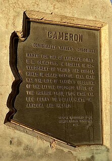
Cameron is a census-designated place (CDP) in Coconino County, Arizona, United States. The population was 885 at the 2010 census. Most of the town's economy is tourist food and craft stalls, restaurants, and other services for north–south traffic from Flagstaff and Page. There is a ranger station supplying information and hiking permits for the Navajo Nation as well as a small selection of books for sale. There is also a large craft store run by the Nation itself; most vendors in the area operate from small private stalls. It is named after Ralph H. Cameron, Arizona's first senator.
Tonto Basin is a census-designated place (CDP) in Gila County, Arizona, United States. The population was 1,424 at the 2010 United States Census, up from 840 in 2000.

Keams Canyon is a census-designated place (CDP) in Navajo County, Arizona, United States. The population was 304 at the 2010 census.
Drexel Heights is an unincorporated community and census-designated place (CDP) in Pima County, Arizona, United States. The population was 27,749 at the 2010 census.

La Luz is a census-designated place (CDP) in Otero County, New Mexico, United States. The population was 1,615 at the 2000 census. It is located immediately north of Alamogordo and lies in the eastern edge of the Tularosa Basin and on the western flank of the Sacramento Mountains. Until 1848, La Luz was a part of Mexico. The CDP gets its name from the Spanish word for "light."

The Wasatch Range or Wasatch Mountains is a mountain range in the western United States that runs about 160 miles (260 km) from the Utah-Idaho border south to central Utah. It is the western edge of the greater Rocky Mountains, and the eastern edge of the Great Basin region. The northern extension of the Wasatch Range, the Bear River Mountains, extends just into Idaho, constituting all of the Wasatch Range in that state.
The Aquarius Plateau is a physiographic region in the High Plateaus Section of the Colorado Plateau Province. It is located within Garfield and Wayne counties in south-central Utah.

Logan Canyon is in the western United States in northeastern Utah, a canyon that cuts its way through the Bear River Mountains, a branch of the Wasatch Range. It is popular for both summer and winter activities, especially rock-climbing, hiking, camping, fishing, snowmobiling, and skiing, at the Beaver Mountain ski resort. The canyon rises to an elevation of approximately 7,800 feet (2,400 m) above sea level, after a vertical climb of about 2,900 feet (880 m). Just beyond the summit is a steep road leading into Bear Lake Valley and scenic overlooks that provide views of deep blue Bear Lake. The western terminus is at Logan in Cache County and the eastern terminus is at Garden City in Rich County.

Gold Canyon is a census-designated place (CDP) and unincorporated community in Pinal County, Arizona, United States. The community is sometimes incorrectly called Gold Camp.

A continuous flow intersection (CFI), also called a crossover displaced left-turn, is an alternative design for an at-grade road junction. Vehicles attempting to turn across the opposing direction of traffic cross before they enter the intersection. No left turn signal in the intersection is then necessary. Instead, vehicles traveling in both directions can proceed, including through vehicles and those turning right or left, when a generic traffic signal/stop sign permits.
The Wave is a sandstone rock formation located in Arizona, United States, near its northern border with Utah. The formation is situated on the slopes of the Coyote Buttes in the Paria Canyon-Vermilion Cliffs Wilderness of the Colorado Plateau. The area is administered by the Bureau of Land Management (BLM) at the Grand Staircase-Escalante National Monument visitor center in Kanab, Utah.

John Harvey Butchart was a mathematics professor who was well known for his hiking exploits in and around the Grand Canyon in Arizona, United States. Beginning in 1945, Butchart explored the Grand Canyon's backcountry on foot. He wrote extensively about his adventures and influenced generations of canyoneers.

High Rolls is an unincorporated community and census-designated place in Otero County, New Mexico, United States. It is nestled within the Lincoln National Forest at the southernmost tip of the Sacramento Mountains. Elevation is approximately 6,750 feet (2,060 m). High Rolls includes a general store, a post office, an elementary school, two churches, and sometimes a bar. High Rolls has many local attractions and festivities for the locals or first time visitor to enjoy. It is also home to two annual festivals, the Cherry Festival and the Apple Festival, both presented by The High Rolls/Mountain Park Lions Club.

Weber Canyon is a canyon in the Wasatch Range near Ogden, Utah, through which the Weber River flows west toward the Great Salt Lake. It is fed by 13 tributary creeks and is 40 miles (64 km) long.

The Siege of Tubac was a siege of the Apache Wars, between settlers and militia of Confederate Arizona and Chiricahua Apaches. The battle took place at Tubac in the present day southern Arizona. The actual dates of this engagement have been lost to time.

Ricks Spring is a karst spring, a natural water outflow from a cave in Logan Canyon within the Wasatch-Cache National Forest in northeast Utah. The spring is not an artesian source, but comes from the Logan River. Ricks Spring is the best known of several springs in an underground water network of the area.
Mollie's Nipple or Molly's Nipple is the name given to as many as seven peaks, at least one butte, at least one well, and some other geological features in Utah. Some sources claim there are eleven geological features in Utah that bear this name. At least some of those names are attributed to John Kitchen – a pioneer of an early exploration of Utah, who named them to commemorate a nipple of his wife Molly.
Denmark Wash is a stream and a canyon in eastern Millard County and north-central Sevier County, Utah, United States.

Kahachi Miliuk is a populated place situated in Pima County, Arizona, United States. It is located in the Fresnal Canyon on the Tohono O'odham Indian Reservation, and its name is derived from the three O'odham words: ge, aji, and meliwkud, meaning "big", "skinny" and "place where runners end a race". It has an estimated elevation of 2,956 feet (901 m) above sea level.
Kuit Vaya is a populated place located within Fresnal Canyon, in Pima County, Arizona, United States. It has an estimated elevation of 3,205 feet (977 m) above sea level. The name comes from the Tohono O'odham kui wahia, meaning "mesquite well".
References
- Vorsila L. Bohrer. 2007. Preceramic subsistence in two rock shelters in Fresnal Canyon, page 12
Coordinates: 31°49′38″N111°38′25″W / 31.827304°N 111.6403905°W
| | This Pima County, Arizona location article is a stub. You can help Wikipedia by expanding it. |