
North Terrace is one of the four terraces that bound the central business and residential district of Adelaide, the capital city of South Australia. It runs east–west, along the northern edge of "the square mile". The western end continues on to Port Road, and the eastern end continues across the Adelaide Parklands as Botanic Road.

The Adelaide Park Lands comprise the figure-eight configuration of land, spanning both banks of the River Torrens between Hackney and Thebarton, which encloses and separates the City of Adelaide area from the surrounding suburbia of greater metropolitan Adelaide, the capital city of South Australia. They were laid out by Colonel William Light in his design for the city, and originally consisted of 2,300 acres (930 ha) "exclusive of 32 acres (13 ha) for a public cemetery". One copy of Light's plan shows areas for a cemetery and a Post and Telegraph Store on West Terrace, a small Government Domain and Barracks on the central part of North Terrace, a hospital on East Terrace, a Botanical Garden on the River Torrens west of North Adelaide, and a school and a storehouse south-west of North Adelaide.

King William Street is the part of a major arterial road that traverses the CBD and centre of Adelaide, continuing as King William Road to the north of North Terrace and south of Greenhill Road; between South Terrace and Greenhill Road it is called Peacock Road. At approximately 40 metres (130 ft) wide, King William Street is the widest main street of all the Australian State capital cities. Named after King William IV in 1837, it is historically considered one of Adelaide's high streets, for its focal point of businesses, shops and other prominent establishments. The Glenelg tram line runs along the middle of the street through the city centre.

Goodwood Road is a major north–south arterial road, approximately 10 kilometres long, in Adelaide, South Australia. It runs between the Adelaide city centre and Adelaide's southern suburbs of Pasadena and Panorama.

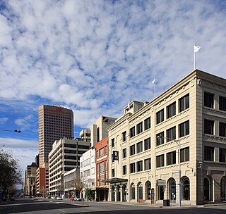
The East End is a part of the Adelaide central business district, in the north-east corner of the Adelaide city centre. This area is a popular office and retail district and has an increasing residential interest from the building of high-density luxury apartments in the area.

Brisbane City is the central suburb and central business district of Brisbane, the state capital of Queensland, Australia. It is colloquially referred to as the "Brisbane CBD" or "the city". It is located on a point on the northern bank of the Brisbane River, historically known as Meanjin, Mianjin or Meeanjin in the local Aboriginal Australian dialect. The triangular shaped area is bounded by the median of the Brisbane River to the east, south and west. The point, known at its tip as Gardens Point, slopes upward to the north-west where the city is bounded by parkland and the inner city suburb of Spring Hill to the north. The CBD is bounded to the north-east by the suburb of Fortitude Valley. To the west the CBD is bounded by Petrie Terrace, which in 2010 was reinstated as a suburb.
Grand Junction Road is the longest east–west thoroughfare in the Adelaide metropolitan area, traversing through Adelaide's northern suburbs approximately 8 kilometres north of the Adelaide city centre.

Adelaide city centre is the inner city locality of Greater Adelaide, the capital city of South Australia. It is known by locals simply as "the City" or "Town" to distinguish it from Greater Adelaide and from the City of Adelaide local government area. The population was 15,115 in the 2016 census.

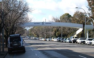
Pulteney Street is a main road which runs north-south through the middle of the eastern half of the Adelaide city centre, in Adelaide, South Australia. It runs north-south from North Terrace, through Hindmarsh and Hurtle Squares, to South Terrace, where it becomes Unley Road. It is the only one of the city centre's major north-south thoroughfares that does not continue northwards over North Terrace.
Morphett Street is a main street in the west of the city centre of Adelaide, South Australia, parallel to King William Street and numbered from north to south. At its northern end it is part of the West End of Adelaide, a thriving cultural and entertainment precinct, with the Lion Arts Centre on the south-western corner of its junction with North Terrace.

Halifax Street is a street in the south-eastern sector of the centre of Adelaide, South Australia. It runs east–west between East Terrace and King William Street, crossing Hutt Street and Pulteney Street and passing through Hurtle Square. It was named after Sir Charles Wood, British Member of Parliament for Halifax.

West Terrace is a street in Adelaide, South Australia. It is the westernmost street of the Adelaide city centre. It ends at North Terrace and South Terrace, and connects to Port Road and Anzac Highway.
Adelaide has two city ring routes, that loop around the Adelaide city centre and North Adelaide, known as the Inner and Outer Ring Routes.

Gilles Street is a street in the south-eastern sector of the centre of Adelaide, South Australia. It runs east–west between East Terrace and King William Street, crossing Hutt Street and Pulteney Street. It was named after Osmond Gilles, an early treasurer of the colony of South Australia on 23 May 1837.

East Terrace marks the eastern edge of the Adelaide city centre. It is one of the main north–south thoroughfares through the east side of the city. Although the terrace essentially runs north–south between North Terrace and South Terrace, unlike Adelaide's other three terraces, its path is far from a straight line; travelling the entire length of East Terrace requires turning at right angles at most intersections from Pirie Street onwards. These days however, the traffic flow, after a swerve to the east between Grenfell and Pirie Streets, continues southwards over the Pirie intersection into Hutt Street and on down to South Terrace.
South Terrace is one of the four terraces which bound the city centre of Adelaide, the capital of South Australia.
Currie Street is a main street in the Adelaide city centre, South Australia. It runs east–to–west from King William Street, through Light Square, to West Terrace on the western edge of the city centre.

Flinders Street is a main street in the city centre of Adelaide, South Australia. It runs from the northern end of Victoria Square to East Terrace. It is one of the intermediate-width streets of the Adelaide grid, at 1+1⁄2 chains wide.

North Adelaide is a predominantly residential precinct and suburb of the City of Adelaide in South Australia, situated north of the River Torrens and within the Adelaide Park Lands.

Frome Street is a street in the East End of the Adelaide city centre, South Australia. It runs from North Terrace in the north to Angas Street, and then as Regent Street North to Carrington Street in the south. North of North Terrace, Frome Street continues towards North Adelaide as Frome Road.


