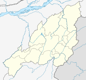
Nagaland is a state in the north-eastern region of India. It is bordered by the Indian states of Arunachal Pradesh to the north, Assam to the west, Manipur to the south, and the Naga Self-Administered Zone of the Sagaing Region of Myanmar (Burma) to the east. Its capital city is Kohima and its largest city is the twin Chümoukedima–Dimapur. The state has an area of 16,579 square kilometres (6,401 sq mi) with a population of 1,980,602 as per the 2011 Census of India, making it one of the smallest states of India.

Mon District is a district of Nagaland, a state in India. It is the third-largest district in Nagaland in terms of area. The district has a population of 250,260 people. Mon Town is the headquarters of the district.

Tuensang District (Pron:/ˌtjuːənˈsæŋ/) is a district in Nagaland, North-East India. Its headquarters is in Tuensang town.

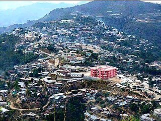
Tuensang is a town located in the north-eastern part of the Indian state of Nagaland. It is the headquarters of the Tuensang District and has a population of 36,774. The town was founded in 1947 for the purpose of administrating the erstwhile North Eastern Frontier Agency (NEFA) that comprised the present day Districts of Tuensang, Mon, Longleng, Kiphire, Noklak and Shamator. Today, these six districts combined are also known as 'Eastern Nagaland'.
The Sangtams are a Naga ethnic group native to the Kiphire District and Tuensang district in the Northeast Indian state of Nagaland.
Longleng district (Pron:/ˈlɒŋˌlɛŋ/) is a hilly district located in the northern part of the Indian state of Nagaland. It is home to the Phom Nagas. Its headquarter is the Longleng town. The boundary of the district is well demarcated by natural rivers such as the Dikhu river. It is bounded by Mon district in the east; Assam in the north; Tuensang district in the south; and Mokokchung district in the west. The mount Yingnyiüshang in the south-eastern part of the district with an approximate height of 2500 meters above sea level is the highest peak.

Kiphire District (Pron:/ˈkɪfɑɪə/) is a district in the Indian state of Nagaland. It is native to the Sangtam Nagas. At 1,130 square kilometres (440 sq mi), as of 2011 the district is the tenth-most populous district of Nagaland. It was craved out of Tuensang district becoming a district in 2004 along with Longleng district. Headquartered at Kiphire town, the district is 230 kilometres from state-capital Kohima.
Khiamniungan is a Sino-Tibetan language spoken by the Khiamniungan people Noklak District of Nagaland located in easternmost part of India bordering Myanmar in the East,Tuensang to the West,Mon to the North and district of Kiphire in the South.There are numerous local -tongues varied from village to village or to geographical ranges, such as Patsho, Thang, Peshu, Nokhu and Wolam.
The Khiamniungans are a Naga ethnic group, with approximately 35% of the population inhabiting in Noklak District in the Northeast Indian state of Nagaland and the rest in the Naga Self-Administered Zone and Hkamti District of Myanmar. They were also called Kalyo-Kengnyu during the British Raj.

The following outline is provided as an overview of and topical guide to Nagaland:
Noklak District is the 12th district of the Indian state of Nagaland. It was established on January 20, 2021. Noklak, the eponymous town, is the headquarters of the district.

Legislative Assembly elections were held in Nagaland on 27 February 2023 to elect all 60 members of the Nagaland Legislative Assembly. The votes were counted and the results were declared on 2 March 2023.

Shamator District is the 16th district of the Indian state of Nagaland. It was created on 19 January 2022 and was officially inaugurated on 4 March 2022. The district headquarter is located in the town of Shamator.
The following is a list of articles relating to the Indian state of Nagaland, sorted in alphabetical order.
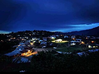
Shamator is a town and the headquarters of the Shamator district in the Indian state of Nagaland.
Patsho, or Pathso, a village in North East India, in the state of Nagaland, is situated in Indo-Burma region of Patkai range. It is considered as one of the biggest villages in Noklak district, located at an altitude of 1415m above sea level. The village is 37 km away from the district headquarter and 72 km from Tuensang, Town.

The Langnyu River is the biggest river in the Noklak district of the Indian state of Nagaland. The Langnyu is an important economic river, supporting agriculture and fishing.
Yokau village also written as Yokao and Yakhao is located in Panso circle of Noklak district in Nagaland, India.It is situated 13 km away from sub-district headquarter Panso and 56 km away from Tuensang. The language most widely spoken is Patsho Khiamniungan, that of the Patsho people there.
The acronym ENPO of the Eastern Nagaland is an apex body of seven Naga tribes in the region whose main focus is on statehood demand.