Sogn og Fjordane was a county in western Norway, up to 1 January 2020 when it was merged to become part of Vestland county. Bordering previous counties Møre og Romsdal, Oppland, Buskerud, and Hordaland, the county administration was in the village of Hermansverk in Leikanger municipality. The largest town in the county was Førde.
Høyanger is a municipality in Vestland county, Norway. It is located in the traditional district of Sogn. The administrative center is the village of Høyanger. Other villages in Høyanger municipality include Austreim, Bjordal, Kyrkjebø, Lavik, Ortnevik, and Vadheim.

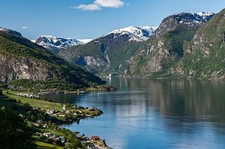
Balestrand is a former municipality in Sogn og Fjordane county, Norway. It was located on the northern shore of the Sognefjorden in the traditional district of Sogn. The administrative center was the village of Balestrand. Other villages in the municipality included Ese, Kvamme, Låne, Sæle, Tjugum, and Vetlefjorden.

Sogndal is a municipality in Vestland county, Norway. It is located on the northern shore of the Sognefjorden in the traditional district of Sogn. The village of Hermansverk is the administrative center of Sogndal municipality. Other villages include Kaupanger, Kjørnes, Fimreite, Nornes, and Fjærland. Sogndal Airport, Haukåsen is located 10 kilometres (6.2 mi) southwest of Kaupanger.

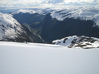
Jostedal Glacier or Jostedalsbreen (Norwegian) is the largest glacier in continental Europe. It is in Vestland county in Western Norway. Jostedalsbreen lies in the municipalities of Luster, Sogndal, Sunnfjord, and Stryn. The highest peak in the area is Lodalskåpa at a height of 2,083 metres (6,834 ft).

Jostedalsbreen National Park is a national park in Norway that encompasses the largest glacier on the European mainland, Jostedalsbreen. The park was established by royal decree on 25 October 1991, and then in 1998, it was enlarged to the northwest. The park now covers 1,310 square kilometres (510 sq mi), with the glaciers covering about 800 square kilometres (310 sq mi) of the park.

Sogndalsfjøra is a village in the municipality of Sogndal in Vestland county, Norway. It is located where the river Sogndalselvi runs out in the Sogndalsfjorden, a branch of the large Sognefjorden. The village is located about 3.5 kilometres (2.2 mi) northwest of the village of Kjørnes, about 10 kilometres (6.2 mi) northwest of the village of Kaupanger, and about 31 kilometres (19 mi) southeast of the village of Fjærland. The village sits at the intersection of Norwegian National Road 5 and Norwegian County Road 55.

Sogndal is a former municipality and small seaport (ladested) in Rogaland county, Norway. The municipality is located on the coast in the traditional district of Dalane. The 19-hectare (47-acre) municipality existed from 1845 until its dissolution in 1944 when it was merged into the municipality of Sokndal. It comprised the two harbor villages: the 7-hectare (17-acre) Sogndalsstranda and the 12-hectare (30-acre) Rægefjord. The river Sogndalselva reaches the ocean at Songdalsstranda.

Fjærland or Mundal is a village in Sogndal Municipality, at the end of the Fjærlandsfjorden, in Vestland county, Norway. The Fjærlandfjorden is a branch going north off the Sognefjorden, the longest fjord in Norway. The village area is located about 31 kilometres (19 mi) northwest of the municipal center of Sogndalsfjøra, along the Norwegian National Road 5. The village and its surrounding area encompass rich farming country, including the nearby areas of Bøyum and Oygard.
The Jostefonn glacier is located in Vestland county, Norway. It covers an area of around 11 square kilometres (4.2 sq mi) in the municipalities of Sunnfjord and Sogndal. Jostefonn was formerly a part of the large Jostedalsbreen glacier, but it is no longer connected to the main glacier. It sits inside the Jostedalsbreen National Park, about 10 kilometres (6.2 mi) east of the village of Haukedalen and about 7 kilometres (4.3 mi) northwest of the village of Fjærland. The Grovabreen glacier lies about 5 kilometres (3.1 mi) north of this glacier.

Hermansverk is the administrative centre of Sogndal Municipality in Vestland County, Norway. The village serves as the seat of the County Governor of Vestland County.
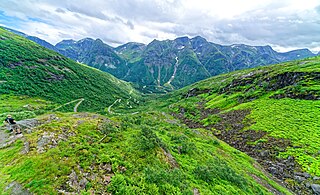
Gaularfjellet is a mountain area in central Vestland county, Norway. The mountains is crossed by the border between the municipalities of Sunnfjord and Sogndal. Norwegian County Road 613 crosses the mountains through a pass that follows the river Gaula, and has a hairpin road. Before the Høyanger tunnel was opened in 1982, a ferry over the fjord or the road over Gaularfjellet were the only accesses to Balestrand, although the road was closed in the winter earlier on.
County Road 613 runs between the village of Dragsvik in Sogndal Municipality and the village of Moskog in Sunnfjord Municipality in Vestland county, Norway.
Mondale is an American surname of Norwegian origin. The surname "Mondale" comes from Mundal by Fjærland, in the Sogndal municipality in Norway.

Bøyabreen is a glacier in the Fjærland area of Sogndal Municipality in Vestland county, Norway. It is located inside Jostedalsbreen National Park, and it is a side branch of the large Jostedalsbreen glacier.

Supphellebreen is a glacier in the Fjærland area of Sogndal Municipality in Vestland county, Norway. It is located about 10 kilometres (6.2 mi) north of the village of Fjærland.

Fjærlandsfjorden is a fjord in Vestland county, Norway. It is a fjord arm that branches off the main Sognefjorden to the north, running through Sogndal Municipality. The 25-kilometre (16 mi) long fjord begins at the village of Fjærland in Sogndal, flowing to the south until it joins the Sognefjorden near the village of Balestrand. The Esefjorden and Vetlefjorden are two small fjord arms that branch off the Fjærdlandsfjorden. The fjord is about 1.5 kilometres (0.93 mi) wide, with steep mountains on both sides of the fjord. The head of the fjord is the only habitable area around the fjord. It is a flat river valley extending north of the fjord. The inner part of the fjord where the village of Fjærland is located is only accessible by boat or via long road tunnels through the surrounding mountains. The western end of the Frudal Tunnel sits very near the shore of the fjord.
The Fjærland Tunnel is a 6,397-metre (3.975 mi) long road tunnel in Vestland county, Norway. The tunnel opened on 31 May 1986 and it is part of Norwegian National Road 5. The opening ceremony was led by former US vice president Walter Mondale who has family connections to Fjærland.

Fjærland Church is a parish church of the Church of Norway in Sogndal Municipality in Vestland county, Norway. It is located in the village of Fjærland, near the northern end of the Fjærlandsfjorden. It is the church for the Fjærland parish which is part of the Sogn prosti (deanery) in the Diocese of Bjørgvin. The white, wooden church was built in a long church design in 1861 using plans drawn up by the architect Christian Henrik Grosch. The church seats about 300 people.

Norwegian National Road 5 is a national road in Norway. It runs between Florø, Kinn to Lærdal, Vestland.
