Fukui Prefectural Varve Museum

Last updated
Fukui Prefectural Varve Museum
Fukui Prefectural Varve Museum Exterior View.jpg
Fukui geolocalisation.svg
Red pog.svg
Location of Fukui Prefectural Varve Museum
Japan location map with side map of the Ryukyu Islands.svg
Red pog.svg
Fukui Prefectural Varve Museum (Japan)
Location122-121-1 Torihama, Wakasa, Mikatakaminaka, Fukui Prefecture
Coordinates 35°33′33″N135°53′50″E / 35.559056°N 135.897278°E / 35.559056; 135.897278
Type geological museum
DirectorKazuma Yamane
Public transit access JR West Obama Line Mikata Station
Website http://varve-museum.pref.fukui.lg.jp

Fukui Prefectural Varve Museum is a geological and archeological museum located in Wakasa, Mikatakaminaka District, Fukui Prefecture, Japan. It features varve ranging from 70,000 years ago to the present, as found at the bottom of Lake Suigetsu. The special chairman is Kazuma Yamane. [1] [2]

Contents

Main Exhibition

A thin section of varve on display in Fukui Prefectural Varve Museum. Showing evidence of eruption of Kikai Caldera. Fukui Prefectural Varve Museum Varve sample.jpg
A thin section of varve on display in Fukui Prefectural Varve Museum. Showing evidence of eruption of Kikai Caldera.
A thin section of varve on display in Fukui Prefectural Varve Museum. A higher magnification. Fukui Prefectural Varve Museum Varve sample magnification.jpg
A thin section of varve on display in Fukui Prefectural Varve Museum. A higher magnification.
Interior view of Fukui Prefectural Varve Museum. Thin section of varve on display. Fukui Prefectural Varve Museum Interior View.jpg
Interior view of Fukui Prefectural Varve Museum. Thin section of varve on display.
Interior view of Fukui Prefectural Varve Museum. Varve and various historical/archaeological evidence are discussed together. Interior view of Fukui Prefectural Varve Museum.jpg
Interior view of Fukui Prefectural Varve Museum. Varve and various historical/archaeological evidence are discussed together.

Lake Suigetsu, one of Five Lakes of Mikata, is located in Wakasa Town, Mikatakaminaka District, Fukui Prefecture. It is a brackish water lake, with an area of 4.06 km², a perimeter of 9.85 km, and a maximum depth of 38.0 m, making it the largest among the five. It lacks directly inflowing river which can disturb the precipitate on the lake bottom. Because of this, the sediments annually form varve and then remain undisturbed. In addition, the lack of oxygen in the water at the lake bottom make it inhabitable to lifeforms, which also helps to keep the varve undisturbed. Also, because of a fault running nearby, the lake gradually lowers its altitude and is never filled up with sediments. With these serendipitous conditions combined, the varve found in the Lake Suigetsu is now known as “Miraculous Sediments”.

The investigation of Lake Suigetsu started on 1991. In boring expedition on 2006, it was not possible to recover 70 m-long varve as one continuous core. Therefore the boring was conducted from 4 different spots, each 1 m long at a time. By matching varve patterns between the core samples, a 70 m-long varve was reconstituted. This equals to a 160,000 year-long varve without any discontinuity and was named SG06 (from Suigetsu, 2006). A team of international collaboration members from Japan, UK, and Germany measured the ratio between radiocarbon 14C and stable isotope 12C throughout the layers of the varve and obtained calibration data of radiocarbon dating 11,200 – 52,800 years ago. This result was published in Science [3] . The error of this calibration is estimated to be about 170 years in 50,000. From this precision, the data obtained from Lake Suigetsu is determined to be the world de facto standard of the radiocarbon dating for geological science in International Radiocarbon Conference held in UNESCO Headaquater in France on July 13, 2014. [4] [5]

This museum introduces research on the varve in Lake Suigetsu. A thin-sectioned 45 meter-long sample of varve embedded in epoxy is on display. [1] Other exhibitions cover the formation of varve in Lake Suigetsu, varves from around the world, the paleoclimate around Lake Suigetsu decoded from the varve, and other archeoclimatological findings. Some of the exhibitions have QR codes to read explanation. However, at this point, the explanations are given only in Japanese.

Access

Facilities Nearby

Located within Jomon Roman Park, near Lake Mikata, at the mouth of Hasu river. Also located in the park are, Wakasa Mikata Jomon Museum, Jomon Colosseum, Roadside station "Michino Eki, Five Lakes of Mikata" and Fukui Prefectural Satoyama-Satoumi Research Institute.

Visitor Information

Closed on Tuesdays (except on holidays, in which case it is closed on the following Wednesday) and at the end and beginning of the year. Discount rates apply to a joint ticket with the Wakasa Mikata Jomon Museum.

See also

Related Research Articles

<span class="mw-page-title-main">Fukui Prefecture</span> Prefecture of Japan

Fukui Prefecture is a prefecture of Japan located in the Chūbu region of Honshū. Fukui Prefecture has a population of 778,943 and has a geographic area of 4,190 km2. Fukui Prefecture borders Ishikawa Prefecture to the north, Gifu Prefecture to the east, Shiga Prefecture to the south, and Kyoto Prefecture to the southwest.

<span class="mw-page-title-main">Tsuruga, Fukui</span> City in Fukui, Japan

Tsuruga is a city located in Fukui Prefecture, Japan. As of 29 June 2018, the city had an estimated population of 66,123 in 28,604 households and the population density of 260 persons per km2. The total area of the city was 251.39 square kilometres (97.06 sq mi).

<span class="mw-page-title-main">Obama, Fukui</span> City in Chūbu, Japan

Obama is a city located in Fukui Prefecture, Japan. As of 1 August 2018, the city had an estimated population of 29,435 in 12,057 households and a population density of 240 persons per km2. The total area of the city was 233.09 square kilometres (90.00 sq mi). Obama gained publicity in the United States and elsewhere in 2008, as it shares its name with Barack Obama, who was running for, and later became, President of the United States.

<span class="mw-page-title-main">Takayama, Gifu</span> City in Gifu Prefecture, Japan

Takayama is a city located in Gifu Prefecture, Japan. As of 1 January 2019, the city had an estimated population of 88,473 in 35,644 households, and a population density of 41 persons per km2. The total area of the city was 2,177.61 square kilometers (840.78 sq mi) making it the largest city by area in Japan. The high altitude and separation from other areas of Japan kept the area fairly isolated, allowing Takayama to develop its own culture over about a 300-year period.

Mikata was a town located in Mikata District, Fukui Prefecture, Japan.

<span class="mw-page-title-main">Mihama, Fukui</span> Town in Chūbu, Japan

Mihama is a town located in Fukui Prefecture, Japan. As of 1 May 2018, the city had an estimated population of 9,643 in 3175 households and the population density of 63 persons per km². The total area of the town was 152.35 square kilometres (58.82 sq mi).

Mikata is a district located in Fukui Prefecture, Japan.

Kaminaka was a town located in Onyū District, Fukui Prefecture, Japan.

Onyū was a district located in the Wakasa Region of Fukui Prefecture, Japan until 2005.

<span class="mw-page-title-main">Varve</span> Annual layer of sediment or sedimentary rock

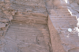
A varve is an annual layer of sediment or sedimentary rock.

<span class="mw-page-title-main">Mikatakaminaka District, Fukui</span>

Mikatakaminaka is a district located in Fukui Prefecture, Japan. The district was formed on March 31, 2005 at the same time as the merger of the towns of Mikata and Kaminaka forming the town of Wakasa.

<span class="mw-page-title-main">Wakasa, Fukui</span> Town in Chūbu, Japan

Wakasa is a town located in Fukui Prefecture, Japan. As of 1 April 2018, the city had an estimated population of 14,577 and the population density of 82 persons per km². The total area of the town was 178.49 square kilometres (68.92 sq mi).

<span class="mw-page-title-main">Fukui Railway</span> Bus & railway company in Fukui Prefecture, Japan

Fukui Railway is a bus and railway company located in Echizen, Fukui Prefecture, Japan. It owns and operates the Fukubu Line between Tawaramachi Station in Fukui and Takefu-shin Station in Echizen.

<span class="mw-page-title-main">Mikata Station</span> Railway station in Wakasa, Fukui Prefecture, Japan

Mikata Station is a railway station in the town of Wakasa, Mikatakaminaka District, Fukui Prefecture, Japan, operated by West Japan Railway Company.

<span class="mw-page-title-main">Lake Suigetsu</span> Lake in Wakasa, Japan

Lake Suigetsu is a lake in the Hokuriku region of Honshu, Japan, which is one of the Mikata Five Lakes located in Mihama and Wakasa, Fukui Prefecture, close to the coast of the Wakasa Bay in the Sea of Japan. Since 1993, it has been attracting the attention of scientists because of the undisturbed nature of the water for many thousands of years. It is possible to identify the annual deposits of silt in a similar manner that tree rings are identified.

<span class="mw-page-title-main">Jōmon period</span> Japanese prehistorical period

In Japanese history, the Jōmon period is the time between c. 14,000 and 300 BC, during which Japan was inhabited by a diverse hunter-gatherer and early agriculturalist population united through a common Jōmon culture, which reached a considerable degree of sedentism and cultural complexity. The name "cord-marked" was first applied by the American zoologist and orientalist Edward S. Morse, who discovered sherds of pottery in 1877 and subsequently translated it into Japanese as Jōmon. The pottery style characteristic of the first phases of Jōmon culture was decorated by impressing cords into the surface of wet clay and is generally accepted to be among the oldest in the world.

<span class="mw-page-title-main">Torihama shell mound</span> Ancient settlement remains in Japan

The Torihama shell mound is a shell midden and remains of an Early Jōmon period settlement located in the Torihama neighbourhood of the town of Wakasa, Fukui, in the Hokuriku region of Japan. It is a waterlogged midden site that was occupied mainly from the Incipient Jomon period to the Early Jomon period from 12,000 to 5,000 years ago.

<span class="mw-page-title-main">Wakasa Mikata Jomon Museum</span> Archeological museum in Mikatakaminaka, Fukui Prefecture

Wakasa Mikata Jomon Museum (若狭三方縄文博物館) is an archeological museum located in the town of Wakasa, Fukui Prefecture, Japan. It is dedicated to the exhibition of Torihama shell mound as well as varve, oldest of which dating back to 70,000 years ago, discovered in the bottom of Lake Suigetsu, one of the Five Lakes of Mikata. The founding chairman is Takeshi Umehara.

<span class="mw-page-title-main">Mikata Five Lakes</span>

Mikata Five Lakes, also called the Five Lakes of Mikata, are a series of brackish and freshwater lakes located in Mihama and Wakasa, Fukui, Japan, which are close to the coast of Wakasa Bay. They consist of Lakes Mikata (三方湖), Suigetsu (水月湖), Suga (菅湖), Kugushi (久々子湖) and Hiruga (日向湖). These five lakes are all located in Wakasa Wan Quasi-National Park. In 2005 the lakes were designated as a Ramsar site. The Lake Suigetsu is famous for its varves, which were adopted as a global standard for dating geological and historical relics in 2012.

<span class="mw-page-title-main">1586 Tenshō earthquake</span> Earthquake in Japan

The Tenshō earthquake occurred in Japan on January 18, 1586 at 23:00 local time. This earthquake had an estimated seismic magnitude of 7.9, and an epicenter in Honshu's Chūbu region. It caused an estimated 8,000 fatalities and damaged 10,000 houses across the prefectures of Toyama, Hyōgo, Kyōto, Osaka, Nara, Mie, Aichi, Gifu, Fukui, Ishikawa and Shizuoka. Historical documentation of this earthquake was limited because it occurred during the Sengoku period.

References

  1. 1 2 "Official Webpage".
  2. "日経ビジネスオンライン". Archived from the original on 2017-02-10. Retrieved 2018-09-16.
  3. Bronk Ramsey, C.; Staff, R. A.; Bryant, C. L.; Brock, F.; Kitagawa, H.; van der Plicht, J.; Schlolaut, G.; Marshall, M. H.; Brauer, A.; Lamb, H. F.; Payne, R. L.; Tarasov, P. E.; Haraguchi, T.; Gotanda, K.; Yonenobu, H.; Yokoyama, Y.; Tada, R.; Nakagawa, T. (2012). "A Complete Terrestrial Radiocarbon Record for 11.2 to 52.8 kyr B.P." (PDF). Science. 338 (6105): 370–374. Bibcode:2012Sci...338..370B. doi:10.1126/science.1226660. ISSN   0036-8075. PMID   23087245. S2CID   28554111.
  4. "第10回環境サイエンスカフェ 7万本の縞模様と70万粒の花粉-水月湖の土が語る気候変動7万年の歴史 P.12-P.21" (PDF). Hitachi Environmental Foundation HP. Archived from the original (PDF) on 2013-06-26.
  5. "日本人の活躍で5万2800年前まで遡れる年代目盛りが完成 - Scienceが会見". Mynavi News. 2012-10-22. Archived from the original on 2012-10-23.