
The Sellwood Bridge is a deck arch bridge that spans the Willamette River in Portland, Oregon, in the United States. The current bridge opened in 2016 and replaced a 1925 span that had carried the same name. The original bridge was Portland's first fixed-span bridge and, being the only river crossing for miles in each direction, the busiest two-lane bridge in Oregon.

The Ohio and Erie Canal was a canal constructed during the 1820s and early 1830s in Ohio. It connected Akron with the Cuyahoga River near its outlet on Lake Erie in Cleveland, and a few years later, with the Ohio River near Portsmouth. It also had connections to other canal systems in Pennsylvania.
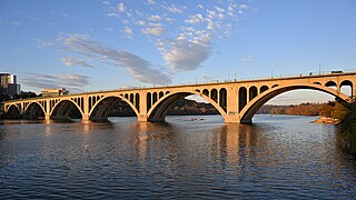
The Francis Scott Key Bridge, more commonly known as the Key Bridge, is a six-lane reinforced concrete arch bridge carrying U.S. Route 29 (US 29) across the Potomac River between the Rosslyn neighborhood of Arlington County, Virginia, and the Georgetown neighborhood of Washington, D.C. Completed in 1923, it is Washington's oldest surviving road bridge across the Potomac River.

The Frederick Douglass Memorial Bridge is a through arch bridge that carries South Capitol Street over the Anacostia River in Washington, D.C. It was completed in 2021 and replaced an older swing bridge that was completed in 1950 as the South Capitol Street Bridge. In 1965, the original bridge was renamed after abolitionist Frederick Douglass. In 2007, the original swing bridge was used by 77,000 daily commuters.

Old Brooklyn is a neighborhood on the West Side of Cleveland, Ohio, United States, located approximately five miles south of downtown Cleveland. It extends east-to-west from the Cuyahoga River to the city of Brooklyn and north-to-south from the Brookside Park Valley to the city of Parma. It is home to the Cleveland Metroparks, including the Cleveland Zoo; the Jesse Owens tree at James Ford Rhodes High School; and the Benjamin Franklin Community Garden, the largest urban community garden in Cuyahoga County. Old Brooklyn has recently adopted the slogan "Old Brooklyn, a great place to grow" to commemorate its history and potential growth.

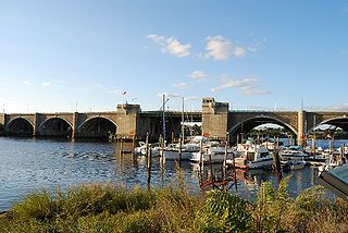
The fourth Berkley–Dighton Bridge is a four-span concrete arch bridge with closed spandrel walls of cast-in-place concrete, using pile-supported abutments and piers. The bridge was made such that it appears to be constructed of stone masonry rather than concrete. The two end spans are 74 feet (23 m) and the two center spans are 92 feet (28 m) for a total bridge length of approximately 350 feet (110 m).

Cleveland Metroparks is an extensive system of nature preserves in Greater Cleveland, Ohio. Eighteen reservations, which largely encircle the city of Cleveland, follow along the shore of Lake Erie and the rivers and creeks that flow through the region. Referred to unofficially as the 'Emerald Necklace', the network of parks spans over 25,000 acres (10,000 ha) and includes over 300 miles (480 km) of walking, bicycle, and horse trails as well as numerous picnic areas, nature education centers, golf courses, and countless fishing spots. In addition, the district includes the zoo in Cleveland. Four of the reservations are adjacent to Cuyahoga Valley National Park.

The Seal Island Bridge is a bridge located in Victoria County, Nova Scotia. It is the third longest bridge span in the province.

The Detroit–Superior Bridge or Detroit–Superior High Level Bridge is a 3,112-foot-long (949 m) through arch bridge over the Cuyahoga River in Cleveland, Ohio. The bridge links Detroit Avenue on Cleveland's west side and Superior Avenue on Cleveland's east side, terminating west of Public Square. Construction by the King Bridge Company began in 1914 and completed in 1918, at a cost of $5.4 million. It was the first fixed high level bridge in Cleveland, and the third high-level bridge above the Cuyahoga. At the time of its completion, the bridge was the largest steel and concrete reinforced bridge in the world.
The Washington Bridge is a series of three bridges carrying Interstate 195, US Route 6, US Route 44, and U.S. Route 1A over the Seekonk River connecting India Point in Providence to Watchemoket Square in East Providence, Rhode Island. The historic portion of the bridge dating to 1930 serves as the pedestrian crossing, and bike link to the East Bay Bike Path. The pedestrian span is also a part of the Washington-Rochambeau National Historic Trail. As of December 11, 2023, the westbound bridge is closed due to critical safety issues. On March 14, 2024, Governor Dan McKee announced that the westbound bridge cannot be repaired. It will remain closed for at least two years so it may be replaced.

The Victoria Bridge crosses the River Severn between Arley and Bewdley in Worcestershire, England. At the time of its construction, the 200-foot railway bridge was the longest single span cast iron bridge in Britain.

The Lamar Boulevard Bridge is a historic arch bridge carrying Texas State Highway Loop 343 over Lady Bird Lake in downtown Austin, Texas, United States. The bridge features six open-spandrel concrete arches spanning 659 feet (201 m) and carries tens of thousands of vehicles daily across the lake. Completed in 1942, the Lamar Boulevard Bridge was the second permanent bridge to cross the Colorado River, and one of the last Art Deco-style open-spandrel concrete arch bridges built in Texas. The bridge was named an Austin Landmark in 1993 and added to the National Register of Historic Places in 1994.
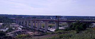
The Valley View Bridge is a trio of steel multi-stringer highway girder bridges that carry Interstate 480 over the Cuyahoga River valley in Valley View and Independence, Ohio. They are 215 feet (66 m) high and 4,150 feet (1,260 m) long.

The U.S. 40 and 59 Bridges are twin multi-beam girder bridges over the Kansas River at Lawrence, Kansas. The west bridge carries two lanes of southbound traffic, connecting to Vermont Street, while the east bridge carries two lanes of northbound traffic from Massachusetts Street. Both bridges converge on the north end to become North 2nd Street. The east bridge is also the third bridge to be built at this location.

The Walterdale Bridge is a through arch bridge across the North Saskatchewan River in Edmonton, Alberta, Canada. It replaced the previous Walterdale Bridge in 2017. The new bridge has three lanes for northbound vehicular traffic and improved pedestrian and cyclist crossings.
The Innerbelt Bridge was a truss arch bridge in Cleveland, Ohio carrying Interstate 90/Innerbelt Freeway over the Cuyahoga River.
The Yadkin River bridges are bridges crossing the Yadkin River between Rowan and Davidson Counties near Spencer, North Carolina in the United States. The northbound span of the Yadkin River Veterans Memorial Bridge, the first of two carrying Interstate 85 / U.S. Highway 52, opened May 5, 2012, and on August 2, 2012, southbound traffic moved to that span as well. A southbound span of the same bridge was completed in October 2012 and opened to traffic in March 2013. Each span carries four lanes of traffic.

The East River Bridge is a multi-span bridge in Sheet Harbour, Nova Scotia that carries Trunk 7 and the Marine Drive scenic route over the Northeast Arm of Sheet Harbour. The bridge is 183 m (600 ft) in length and was constructed from September 2014 to December 2015. It was opened on December 17, 2015 to pedestrians, with a bridge walk commemorating the closing of the old bridge and the opening of the new bridge. The bridge was opened to vehicles the day after. It replaced a green steel arch bridge of the same name that was built in 1956 immediately north of the current bridge. The previous bridge had a span of 213 m (699 ft) and shared engineering ties with the Angus L. MacDonald Bridge in Halifax. Nova Scotia was considering repairs to the old bridge, but they ultimately elected to construct a new bridge instead. The current bridge was designed without overhead arches, unlike its predecessor, as the construction cost would have been doubled.

The Quechee Gorge Bridge is a historic bridge, carrying U.S. Route 4 (US 4) across Quechee Gorge, near the Quechee village of Hartford, Vermont. Built in 1911, it is Vermont's oldest surviving steel arch bridge. It was listed on the National Register of Historic Places in 1990.

The Cleveland Foundation Centennial Lake Link Trail, originally known as the Lake Link Trail, is a cycling, hiking, and walking trail located in the city of Cleveland, Ohio, in the United States. Owned by the city of Cleveland and maintained by Cleveland Metroparks, the trail runs along the former track bed of the Cleveland and Mahoning Valley Railroad. The trail is named for The Cleveland Foundation, a local community foundation which donated $5 million toward the trail's construction. The southern leg of the 1.3-mile (2.1 km) trail opened in August 2015, and the northern leg in August 2017. The middle leg will begin construction once the Irishtown Bend hillside is stabilized. A bridge connecting the trail to Whiskey Island will begin construction in Spring 2019 and will be completed in early Summer 2020.


