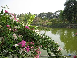
Tando Jam is a town and a municipal committee of Hyderabad District in the Sindh province of Pakistan. It lies on the east of Hyderabad Taluka, about 12 kilometres northeast of the city center. As of 2017, Its population is 71,760.
Nitte is a village in Karkala Taluk, Udupi District, Karnataka, India. It is located on the way from Padubidri to Karkala, about 26 kilometres southeast of the district capital Udupi, and 7 kilometres southwest of the taluka capital Karkala. In the year 2011, the village is home to 12,354 inhabitants.

Wandoor is a town in Nilambur Taluk, Malappuram District, Kerala, India. It is located on the southeast of Chaliyar River, about 24 kilometres northeast of the district seat Malappuram, and 8 km south of the taluk seat Nilambur. In the year 2011, the town has a population of 50,973.
B. Kothakota is a town and nagar panchayat in Thamballapalle assembly constituency, Annamayya district, Andhra Pradesh, India. Beerangi Kottakota is known as B.Kothakota. It is located near the state border with Karnataka, approximately 68 kilometres southwest of the district capital Rayachoti. In the year 2011, the town has a total population of 26,191. In the year 2020 Andhrapradesh state government declared B.Kothakota as Nagar Panchayat. Horsley hills is located near to B.Kothakota.

Thevalakkara is a village in the Karunagappally Taluk, Kollam District of the state of Kerala, India. It is located near the coast of the Indian Ocean, about 13 kilometres north of the district capital Kollam, and 7 kilometres southeast of the subdistrict capital Karunagappally. It contains a Devi temple along with a church and a mosque. The kadappa at Thevalakara is where ship masts (kadappa) were made for centuries. In 2011, it has a total population of 42,977.
Chinchali is a village in Raybag Taluk, Belagavi District, Karnataka, India. It is located near the state boundary with Maharashtra, approximately 84 kilometres north of the district seat Belgaum, and 10 kilometres northeast of the taluk seat Raibag. In the year 2011, the village has a population of 18,986.

Dadra is one of the two talukas in Dadra and Nagar Haveli district, India. It is an enclave lying a few kilometres north west of Nagar Haveli and is surrounded by Gujarat.
Mohare is a village in Bailhongal Taluk, Belagavi District of Karnataka, India. It is located near the state border with Maharashtra, about 26 kilometres east of the district seat Belgaum, and 16 kilometres northwest of the taluk seat Bailhongal. As of 2011, it has a total population of 2,365.

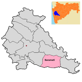
Baramati taluka is a taluka in Baramati subdivision of Pune district of state of Maharashtra in India.

Bhor taluka is a taluka in Haveli subdivision of Pune district of state of Maharashtra in India. There are 195 villages and 1 town in Bhor Taluka.

Taluka Haveli is a subdivision of the district of Pune, Maharashtra. The Pune Municipal Corporation & Pimpri Chinchwad Municipal Corporation, Pune are at the center of & entirely surrounded by the taluka for administrative purposes. The region of Pune Metropolitan Region has claimed the major part of the same.

Shirur taluka, is a taluka in Haveli subdivision of Pune district of state of Maharashtra in India. The town is situated on the bank of river Ghod and hence it was also known as Ghodnadi in 20th Century. The town is on the border of Pune & Ahmed Nagar District and hence, main trading center for Shirur Taluka as well as Parner Taluka located in Ahmed Nagar District.
Pimpalgaon Baswant is a town in Niphad Taluk, Nashik District, Maharashtra, India. It is located to the north of Kadva River, about 28 kilometres northeast of the district capital Nashik, and 16 kilometres northwest of the taluk capital Niphad. In the year 2011, it is home to 41,559 inhabitants.

Velhe Taluka, officially renamed as, Rajgad Taluka, is a taluka in Haveli subdivision of Pune district of state of Maharashtra in India. The Taluka is entirely rural, and consists of 130 villages.
Chas is a panchayat village in the state of Maharashtra, India, on the left (east) bank of the Bhima River. Administratively, Chas is under Khed Taluka of Pune District in Maharashtra. There is only the single village of Chas in the Chas gram panchayat. The village of Chas is 16 km southeast of the Chas-Kaman Dam, and 14 km by road northwest of the town of Rajgurunagar (Khed).
Ranjangaon Sandus is a panchayat village in the state of Maharashtra, India, on the left (east) bank of the Bhima River just above its intersection with the Mula-Mutha River. Administratively, Ranjangaon Sandas is under Shirur Taluka of Pune District in Maharashtra. The village of Ranjangaon Sandas is 5.5 km by road south of the village of Alegaon Paga, and 38 km by road south of the town of Shirur.
Alegaon Paga is a panchayat village in the state of Maharashtra, India. The village is 2.6 kilometres east of the Bhima River. Administratively, Alegaon Paga is under Shirur Taluka of Pune District in Maharashtra. The village of Alegaon Paga is 5.5 km by road north of the village of Ranjangaon Sandas, and 31 km by road south of the town of Shirur.
Lonikand or Loni-kand or Loni is a village panchayat located towards the northeast of Pune district in the Indian state of Maharashtra and is located in Haveli taluka. It is named after the Kands, the important family of the village. It is located 23 kilometres towards East from Pune, 29 kilometres from Haveli and 152 kilometres from the state capital Mumbai. Wagholi, Fulgaon, Tulapur, Wadebolhai, Perne, Burkhegaon, Vadu are some nearby villages of Lonikand. It is situated on Pune-Nagar State Highway No. 27. The nearest railway station to Lonikand is Hadapsar around 22 kilometres away. Lonikand's nearest airport is Pune Airport situated at 16.7 kilometres' distance. Situated from Pune on 23 kilometres' distance it can be reached by road.
Chahardi is a village in Chopda Taluka, Jalgaon District, Maharashtra, India. It is located at the north of Tapti River, approximately 44 kilometres northwest of the district seat Jalgaon, and 8 kilometres southwest of the subdistrict seat Chopda. As of the year 2010, it has a total population of 11,115.
Manjari Bk is a village in Haveli Taluka, Pune District, Maharashtra, India. It is located in the suburb of Pune, approximately 12 kilometres east of the city center of Pune. In 2011, it had a population of 36,820.


