De Beque Canyon is a narrow canyon on the Colorado River in western Colorado in the United States. It is approximately 15 miles (24 km) long, located on the river downstream from the town of De Beque, in eastern Mesa County. The canyon forms a narrow passage where the river passes along the western end of the Grand Mesa. At its lower end, the canyon opens out on the eastern end of the Grand Valley at the town of Palisade, approximately 10 miles (16 km) east of Grand Junction. Interstate 70 follows the river through the canyon.

The Oglio is a left-side tributary of the Po River in Lombardy, Italy. It is 280 kilometres (170 mi) long. In the hierarchy of the Po's tributaries, with its 280 kilometres (170 mi) of length, it occupies the 2nd place per length, while it is the 4th per basin surface, and the 3rd per average discharge at the mouth.
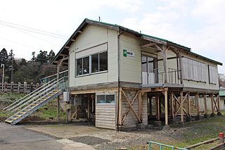
Tsurugata Station is a JR East railway station located in Noshiro, Akita Prefecture, Japan.
Kanbalu is a town in Shwebo District, Sagaing Division, in Myanmar. It is the administrative seat for Kanbalu Township. Kanbalu is on the main Burmese north-south railroad between Sagaing and Myitkyina.

Egypt is an unincorporated community in Jordan Township, Jasper County, Indiana.

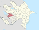
Kənzə is a village in the Ismailli Rayon of Azerbaijan. The village forms part of the municipality of Qoşakənd. According to Azerbaijan's State Statistics Committee, only three people lived in the village as of 2014.

Peyədərə is a village in the Goygol Rayon of Azerbaijan.

Koźniewice is a village in the administrative district of Gmina Kamieńsk, within Radomsko County, Łódź Voivodeship, in central Poland. It lies approximately 3 kilometres (2 mi) west of Kamieńsk, 16 km (10 mi) north of Radomsko, and 65 km (40 mi) south of the regional capital Łódź.
Siedliszowice is a village in the administrative district of Gmina Żabno, within Tarnów County, Lesser Poland Voivodeship, in southern Poland. It lies approximately 12 kilometres (7 mi) north-west of Żabno, 26 km (16 mi) north-west of Tarnów, and 62 km (39 mi) east of the regional capital Kraków.
Suchary is a village in the administrative district of Gmina Wilczyn, within Konin County, Greater Poland Voivodeship, in west-central Poland. It lies approximately 6 kilometres (4 mi) south of Wilczyn, 27 km (17 mi) north of Konin, and 84 km (52 mi) east of the regional capital Poznań.
Mikoszki is a village in the administrative district of Gmina Kościan, within Kościan County, Greater Poland Voivodeship, in west-central Poland. It lies approximately 8 kilometres (5 mi) north of Kościan and 33 km (21 mi) south-west of the regional capital Poznań.

Sławienko is a village in the administrative district of Gmina Rudnik, within Racibórz County, Silesian Voivodeship, in southern Poland. It lies approximately 6 kilometres (4 mi) north-west of Rudnik, 12 km (7 mi) north-west of Racibórz, and 65 km (40 mi) west of the regional capital Katowice.

Dobrzykowo is a village in the administrative district of Gmina Barciany, within Kętrzyn County, Warmian-Masurian Voivodeship, in northern Poland, close to the border with the Kaliningrad Oblast of Russia. It lies approximately 14 kilometres (9 mi) north-west of Barciany, 28 km (17 mi) north-west of Kętrzyn, and 74 km (46 mi) north-east of the regional capital Olsztyn.
Gwizd is a village in the administrative district of Gmina Ustronie Morskie, within Kołobrzeg County, West Pomeranian Voivodeship, in north-western Poland. It lies approximately 3 kilometres (2 mi) south-east of Ustronie Morskie, 15 km (9 mi) east of Kołobrzeg, and 118 km (73 mi) north-east of the regional capital Szczecin.
Tammiku (Kose) is a village in Kose Parish, Harju County in northern Estonia.
Velika Petrovagorska is a village in Croatia. It is connected by the D29 highway.
Valentinovo is a village in Croatia. It is connected by the D206 highway.
Qarqa is a village in Abarghan Rural District, in the Central District of Sarab County, East Azerbaijan Province, Iran. At the 2006 census, its population was 398, in 73 families.
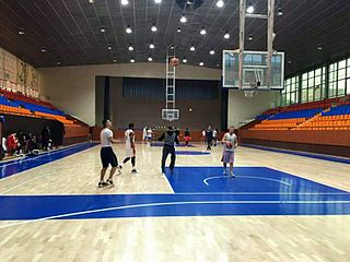
Mika Sports Arena, is a multi-purpose sports arena located in the Shengavit District of Yerevan, the capital of Armenia. It has a capacity of 1,200 spectators.
Ione is an unincorporated community in Weld County, Colorado.