Předhradí is a village in the Pardubice Region of the Czech Republic. It has around 460 inhabitants.

Orta, formerly Kari Pazarı, is a town and district of Çankırı Province in the Central Anatolia region of Turkey.

Erlach District was one of the 26 administrative districts in the canton of Bern, Switzerland. Its capital was Erlach. The district had an area of 96 km² and consists of 12 municipalities:
Meerbeke is a village in the Denderstreek in the province of East Flanders in Belgium. Administratively it is part of the municipality of Ninove. This rural community is located along the Dender River on the western border of what is known as "Pajottenland". With a total surface of 1047ha it is the second largest village in Ninove. With 5.792 inhabitants it's the most populated village in Ninove, next to the centre of Ninove itself. It is perhaps most known as the arrival location for the Flemish cycling race the Tour of Flanders (1973-2011).
Zlatá is a village in the Central Bohemian Region of the Czech Republic. On the date October 2, 2006 it has 94 inhabitants. First written notice about village is from year 1357. The municipality lies at an altitude of 307 metres and covers an area of 1.12 km².
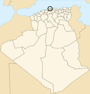
Bouzaréah is a district in Algiers Province, Algeria. It was named after its capital, Bouzaréah.

Atdash is a town in the Gegharkunik Province of Armenia.

Călinești is a commune in Argeș County, in southern central Romania. It is composed of twelve villages: Călinești, Ciocănești, Cârstieni, Glodu, Gorganu, Radu Negru, Râncăciov, Udeni-Zăvoi, Urlucea, Valea Corbului, Văleni-Podgoria and Vrănești.

Orta Günəypəyə is a village in the Agdam Rayon of Azerbaijan.
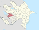
Orta Qərvənd is a village in the Agdam Rayon of Azerbaijan. The village forms part of the municipality of Qərvənd. A 9 year old resident of Orta Qərvənd was shot by the Armenian sniper in March 8, 2011. The Armenian armed forces shot him from the direction of Şıxlar village while he was playing in the yard.
Orta Yeməzli is a village in the Zangilan Rayon of Azerbaijan.

Chrzemce is a village in the administrative district of Gmina Lubochnia, within Tomaszów Mazowiecki County, Łódź Voivodeship, in central Poland. It lies approximately 4 kilometres (2 mi) south of Lubochnia, 7 km (4 mi) north of Tomaszów Mazowiecki, and 46 km (29 mi) south-east of the regional capital Łódź.
Borek is a village in the administrative district of Gmina Przemęt, within Wolsztyn County, Greater Poland Voivodeship, in west-central Poland.
Ciemnica is a village in the administrative district of Gmina Trzebielino, within Bytów County, Pomeranian Voivodeship, in northern Poland.
Strysza Góra is a settlement in the administrative district of Gmina Chmielno, within Kartuzy County, Pomeranian Voivodeship, in northern Poland. It lies approximately 5 kilometres (3 mi) north-west of Chmielno, 11 km (7 mi) west of Kartuzy, and 39 km (24 mi) west of the regional capital Gdańsk.
The Pandaruan River is an international river on the island of Borneo. The river mouth is on Brunei Bay.

Ben Srour is a town and commune in M'Sila Province, Algeria.
Sušobreg is a village in Croatia.
Izumno is a village in the municipality of Vranje, Serbia. According to the 2002 census, the village has a population of 357 people.
Dellvale is an unincorporated community in Norton County, Kansas, in the United States.