Grabownica is a village in the administrative district of Gmina Krośnice, within Milicz County, Lower Silesian Voivodeship, in south-western Poland. Prior to 1945 it was in Germany.
Nowoszyce is a village in the administrative district of Gmina Oleśnica, within Oleśnica County, Lower Silesian Voivodeship, in south-western Poland. Prior to 1945 it was in Germany. It lies approximately 7 kilometres (4 mi) east of Oleśnica and 31 km (19 mi) east of the regional capital Wrocław.

Miedzna is a village in Węgrów County, Masovian Voivodeship, in east-central Poland, in the historical region of Podlachia. It is the seat of the gmina called Gmina Miedzna. It lies approximately 8.5 kilometres (5 mi) north-east of Węgrów and 80 km (50 mi) east of Warsaw.
Marianki is a village in the administrative district of Gmina Tłuchowo, within Lipno County, Kuyavian-Pomeranian Voivodeship, in north-central Poland. It lies approximately 2 kilometres (1 mi) north of Tłuchowo, 23 km (14 mi) south-east of Lipno, and 65 km (40 mi) south-east of Toruń.
Krężnica Okrągła is a village in the administrative district of Gmina Bełżyce, within Lublin County, Lublin Voivodeship, in eastern Poland. It lies approximately 3 kilometres (2 mi) south-west of Bełżyce and 25 km (16 mi) west of the regional capital Lublin.
Zalesie is a village in the administrative district of Gmina Nurzec-Stacja, within Siemiatycze County, Podlaskie Voivodeship, in north-eastern Poland, close to the border with Belarus. It lies approximately 3 kilometres (2 mi) west of Nurzec-Stacja, 14 km (9 mi) east of Siemiatycze, and 73 km (45 mi) south of the regional capital Białystok.
Zbysław is a village in the administrative district of Gmina Bytów, within Bytów County, Pomeranian Voivodeship, in northern Poland. It lies approximately 13 kilometres (8 mi) north of Bytów and 77 km (48 mi) west of the regional capital Gdańsk.
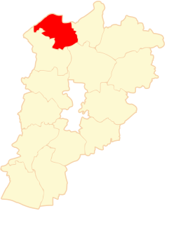
Huta Szumy is a village in the administrative district of Gmina Susiec, within Tomaszów Lubelski County, Lublin Voivodeship, in eastern Poland.
Czysta is a village in the administrative district of Gmina Końskie, within Końskie County, Świętokrzyskie Voivodeship, in south-central Poland.
Lewoszów is a village in the administrative district of Gmina Radoszyce, within Końskie County, Świętokrzyskie Voivodeship, in south-central Poland. It lies approximately 4 kilometres (2 mi) south of Radoszyce, 22 km (14 mi) south-west of Końskie, and 32 km (20 mi) north-west of the regional capital Kielce.
Stobiec is a village in the administrative district of Gmina Iwaniska, within Opatów County, Świętokrzyskie Voivodeship, in south-central Poland. It lies approximately 3 kilometres (2 mi) north-west of Iwaniska, 15 km (9 mi) south-west of Opatów, and 47 km (29 mi) east of the regional capital Kielce.
Helenów is a village in the administrative district of Gmina Głowaczów, within Kozienice County, Masovian Voivodeship, in east-central Poland.
Pawłowice is a village in the administrative district of Gmina Teresin, within Sochaczew County, Masovian Voivodeship, in east-central Poland. It lies approximately 16 kilometres (10 mi) east of Sochaczew and 37 km (23 mi) west of Warsaw.
Działy Czarnowskie is a village in the administrative district of Gmina Dąbrówka, within Wołomin County, Masovian Voivodeship, in east-central Poland.
Bronibór is a village in the administrative district of Gmina Szczytniki, within Kalisz County, Greater Poland Voivodeship, in west-central Poland.
Ciemnica is a village in the administrative district of Gmina Trzebielino, within Bytów County, Pomeranian Voivodeship, in northern Poland.
Okalice is a village in the administrative district of Gmina Cewice, within Lębork County, Pomeranian Voivodeship, in northern Poland. It lies approximately 8 kilometres (5 mi) north-east of Cewice, 11 km (7 mi) south-east of Lębork, and 53 km (33 mi) west of the regional capital Gdańsk.
Szemudzka Huta is a village in the administrative district of Gmina Szemud, within Wejherowo County, Pomeranian Voivodeship, in northern Poland. It lies approximately 3 kilometres (2 mi) south of Szemud, 15 km (9 mi) south of Wejherowo, and 29 km (18 mi) north-west of the regional capital Gdańsk.
Modgarby is a village in the administrative district of Gmina Barciany, within Kętrzyn County, Warmian-Masurian Voivodeship, in northern Poland, close to the border with the Kaliningrad Oblast of Russia. It lies approximately 7 kilometres (4 mi) north-west of Barciany, 20 km (12 mi) north-west of Kętrzyn, and 71 km (44 mi) north-east of the regional capital Olsztyn.
Kurzycko is a village in the administrative district of Gmina Mieszkowice, within Gryfino County, West Pomeranian Voivodeship, in north-western Poland, close to the German border. It lies approximately 3 kilometres (2 mi) south-west of Mieszkowice, 55 km (34 mi) south of Gryfino, and 74 km (46 mi) south of the regional capital Szczecin.