General Packet Radio Service (GPRS) is a packet oriented mobile data standard on the 2G and 3G cellular communication network's global system for mobile communications (GSM). GPRS was established by European Telecommunications Standards Institute (ETSI) in response to the earlier CDPD and i-mode packet-switched cellular technologies. It is now maintained by the 3rd Generation Partnership Project (3GPP).

Telemetry is the in situ collection of measurements or other data at remote points and their automatic transmission to receiving equipment (telecommunication) for monitoring. The word is derived from the Greek roots tele, "remote", and metron, "measure". Systems that need external instructions and data to operate require the counterpart of telemetry, telecommand.

Ultra high frequency (UHF) is the ITU designation for radio frequencies in the range between 300 megahertz (MHz) and 3 gigahertz (GHz), also known as the decimetre band as the wavelengths range from one meter to one tenth of a meter. Radio waves with frequencies above the UHF band fall into the super-high frequency (SHF) or microwave frequency range. Lower frequency signals fall into the VHF or lower bands. UHF radio waves propagate mainly by line of sight; they are blocked by hills and large buildings although the transmission through building walls is strong enough for indoor reception. They are used for television broadcasting, cell phones, satellite communication including GPS, personal radio services including Wi-Fi and Bluetooth, walkie-talkies, cordless phones, and numerous other applications.
Automatic vehicle location is a means for automatically determining and transmitting the geographic location of a vehicle. This vehicle location data, from one or more vehicles, may then be collected by a vehicle tracking system to manage an overview of vehicle travel. As of 2017, GPS technology has reached the point of having the transmitting device be smaller than the size of a human thumb, able to run 6 months or more between battery charges, easy to communicate with smartphones — all for less than $20 USD.

Argos is a satellite-based system which collects, processes and disseminates environmental data from fixed and mobile platforms worldwide. In addition to satellite data collection, what makes Argos more useful is the ability to geographically locate the data source from any location on Earth using the Doppler effect.
The design of spacecraft covers a broad area, including the design of both robotic spacecraft, and spacecraft for human spaceflight.
An animal collar is a device that attaches to the neck of an animal to allow it to be harnessed or restrained.
A drilling rig is used to create a borehole or well in the earth's sub-surface, for example in order to extract natural resources such as gas or oil. During such drilling, data is acquired from the drilling rig sensors for a range of purposes such as: decision-support to monitor and manage the smooth operation of drilling; to make detailed records of the geologic formations penetrated by a borehole; to generate operations statistics and performance benchmarks such that improvements can be identified, and to provide well planners with accurate historical operations-performance data with which to perform statistical risk analysis for future well operations. The terms measurement while drilling (MWD), and logging while drilling (LWD) are not used consistently throughout the industry. Although these terms are related, within the context of this section, the term MWD refers to directional-drilling measurements, e.g., for decision support for the wellbore path, while LWD refers to measurements concerning the geological formations penetrated while drilling.
A GPS tracking unit, geotracking unit, or simply tracker is a navigation device normally on a vehicle, asset, person or animal that uses the Global Positioning System (GPS) to determine its movement and determine its WGS84 UTM geographic position (geotracking) to determine its location.

Animal migration tracking is used in wildlife biology, conservation biology, ecology, and wildlife management to study animals' behavior in the wild. One of the first techniques was bird banding, placing passive ID tags on birds legs, to identify the bird in a future catch-and-release. Radio tracking involves attaching a small radio transmitter to the animal and following the signal with a RDF receiver. Sophisticated modern techniques use satellites to track tagged animals, and GPS tags which keep a log of the animal's location. One of the many goals of animal migration research has been to determine where the animals are going; however, researchers also want to know why they are going "there". Researchers not only look at the animals' migration but also what is between the migration endpoints to determine if a species is moving to new locations based on food density, a change in water temperature, or other stimulus, and the animal's ability to adapt to these changes. Migration tracking is a vital tool in efforts to control the impact of human civilization on populations of wild animals, and prevent or mitigate the ongoing extinction of endangered species.

Vessel Monitoring Systems (VMS) is a general term to describe systems that are used in commercial fishing to allow environmental and fisheries regulatory organizations to track and monitor the activities of fishing vessels. They are a key part of monitoring control and surveillance (MCS) programs at national and international levels. VMS may be used to monitor vessels in the territorial waters of a country or a subdivision of a country, or in the Exclusive Economic Zones (EEZ) that extend 200 nautical miles (370.4 km) from the coasts of many countries. VMS systems are used to improve the management and sustainability of the marine environment, through ensuring proper fishing practices and the prevention of illegal fishing, and thus protect and enhance the livelihoods of fishermen.

Radio is the technology of signaling and communicating using radio waves. Radio waves are electromagnetic waves of frequency between 30 hertz (Hz) and 300 gigahertz (GHz). They are generated by an electronic device called a transmitter connected to an antenna which radiates the waves, and received by a radio receiver connected to another antenna. Radio is very widely used in modern technology, in radio communication, radar, radio navigation, remote control, remote sensing and other applications.
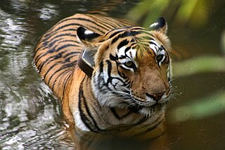
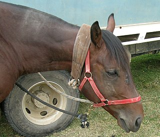
Tracking collars are collars used as a radio beacon to track animal migration for research. Some pet owners use these collars for GPS tracking and geofencing of their pets.

Pop-up satellite archival tags (PSATs) are used to track movements of marine animals. A PSAT is an archival tag that is equipped with a means to transmit the collected data via the Argos satellite system. Though the data are physically stored on the tag, its major advantage is that it does not have to be physically retrieved like an archival tag for the data to be available making it a viable, fishery independent tool for animal behavior and migration studies. They have been used to track movements of ocean sunfish, marlin, blue sharks, bluefin tuna, swordfish and sea turtles to name a few species. Location, depth, temperature, oxygen levels, and body movement data are used to answer questions about migratory patterns, seasonal feeding movements, daily habits, and survival after catch and release, for examples.
The Unified S-band (USB) system is a tracking and communication system developed for the Apollo program by NASA and the Jet Propulsion Laboratory (JPL). It operated in the S band portion of the microwave spectrum, unifying voice communications, television, telemetry, command, tracking and ranging into a single system to save size and weight and simplify operations. The USB ground network was managed by the Goddard Space Flight Center (GSFC). Commercial contractors included Collins Radio, Blaw-Knox, Motorola and Energy Systems.
A data storage tag (DST), also sometimes known as an archival tag, is a combination of a data logger and multiple sensors that record data at predetermined intervals. DSTs usually have a large memory size and a long lifetime: most are supported by batteries that allow the tag to record positions for several years. Alternatively some tags are solar powered and allow the scientist to set their own interval; this then allows data to be recorded for significantly longer than battery-only powered tags.
GPS aircraft tracking is a means of tracking the position of an aircraft fitted with a GPS receiver. By communication with GPS satellites, detailed real-time data on flight variables can be passed to a server on the ground. This server stores the flight data, which can then be transmitted via telecommunications networks to organizations wishing to interpret it.

A light level geolocator, light-level logger or GLS is essentially a lightweight, electronic archival tracking device, usually used in bird migration research to map migration routes, identify important staging areas, and sometimes provide additional ecological information. A geolocator periodically records ambient light level to determine location.
The history of wildlife tracking technology involves the evolution of technologies that have been used to monitor, track, and locate many different types of wildlife. Many individuals have an interest in tracking wildlife, including biologists, scientific researchers, and conservationists. Biotelemetry is "the instrumental technique for gaining and transmitting information from a living organism and its environment to a remote observer".

Since its inception in the 1960s, wildlife radio telemetry has become a valuable tool to track the movement and behavior of animals. This technique uses the transmission of radio signals to locate a transmitter attached to the animal of interest. It is often used to obtain location data on the animal's preferred habitat, home range, and to understand population dynamics. The different types of radio telemetry techniques include very high frequency (VHF) transmitters, global positioning system (GPS) tracking, and satellite tracking. Recent advances in technology have improved radio telemetry techniques by increasing the efficacy of data collection. However, studies involving radio telemetry should be reviewed in order to determine if newer techniques, such as collars that transmit the location to the operator via satellites, are actually required to accomplish the goals of the study.
