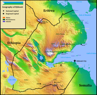
Djibouti is a country in the Horn of Africa. It is bordered by Eritrea in the north, Ethiopia in the west and south, and Somalia in the southeast. To the east is its coastline on the Red Sea and the Gulf of Aden. Rainfall is sparse, and most of the territory has a semi-arid to arid environment. Lake Assal is a saline lake which lies 155 m (509 ft) below sea level, making it the lowest point on land in Africa and the third-lowest point on Earth after the Sea of Galilee and the Dead Sea. Djibouti's major settlements include the capital Djibouti City, the port towns of Tadjoura and Obock, and the southern cities of Ali Sabieh and Dikhil. It is the 147st largest country in the world by land area, covering a total of 23,200 km2, of which 23,180 km2 is land and 20 km2 is water.
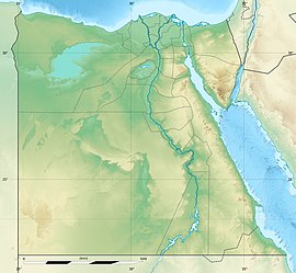
The geography of Egypt relates to two regions: North Africa and Southwest Asia.

Mongolia is a landlocked country in Central Asia and East Asia, located between China and Russia. The terrain is one of mountains and rolling plateaus, with a high degree of relief. The total land area of Mongolia is 1,564,116 square kilometres. Overall, the land slopes from the high Altai Mountains of the west and the north to plains and depressions in the east and the south. The Khüiten Peak in extreme western Mongolia on the Chinese border is the highest point. The lowest point is at 518 m (1,699 ft), an otherwise undistinguished spot in the eastern Mongolian plain. The country has an average elevation of 1,580 m (5,180 ft).

North Africa is a region encompassing the northern portion of the African continent. There is no singularly accepted scope for the region, and it is sometimes defined as stretching from the Atlantic shores of Morocco in the west, to Egypt's Suez Canal and the Red Sea in the east. Others have limited it to top North-Western countries like Algeria, Morocco, and Tunisia, a region that was known by the French during colonial times as "Afrique du Nord" and is known by all Arabs as the Maghreb. The most commonly accepted definition includes Algeria, Sudan, Morocco, Tunisia, Libya and Egypt, the 6 countries that shape the top North of the African continent. Meanwhile, "North Africa", particularly when used in the term North Africa and the Middle East, often refers only to the countries of the Maghreb and Libya. Egypt, being also part of the Middle East, is often considered separately, due to being both North African and Middle Eastern at the same time.

Sudan is located in northeastern Africa. It is bordered by Egypt to the north, the Red Sea to the northeast, Eritrea and Ethiopia to the east, South Sudan to the south, the Central African Republic to the southwest, Chad to the west and Libya to the northwest. Sudan is the third largest country in Africa, after Algeria and DR Congo. It had been the largest country on the continent until the 2011 independence of South Sudan.

Tunisia is a country in Northern Africa, bordering the Mediterranean Sea, having a western border with Algeria (965 km) and south-eastern border with Libya (459 km) where the width of land tapers to the south-west into the Sahara. The country has north, east and complex east-to-north coasts including the curved Gulf of Gabès, which forms the western part of Africa's Gulf of Sidra. Most of this greater gulf forms the main coast of Libya including the city of Sirte which shares its root name. The country's geographic coordinates are 34°00′N9°00′E. Tunisia occupies an area of 163,610 square kilometres, of which 8,250 are water. The principal and reliable rivers rise in the north of the country with a few notable exceptions from north-east Algeria and flow through the northern plain where sufficient rainfall supports diverse plant cover and irrigated agriculture.

The Drakensberg is the name given to the eastern portion of the Great Escarpment, which encloses the central Southern African plateau. The Great Escarpment reaches its greatest elevation in this region – 2,000 to 3,482 metres. It is located in South Africa and Lesotho.

The Libyan Desert forms the northern and eastern part of the Sahara Desert. It describes that part of the Sahara that lies within the present-day state of Libya; it also historically describes the desert to the south of Ancient Libya, a territory which lay to the east of the present-day state. The Libyan Desert is one of the driest, harshest and most remote parts of the Sahara, the world's largest hot desert. This extended desert country is barren, dry and rainless.

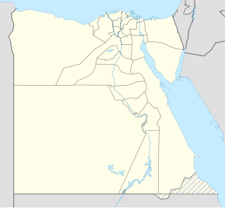
The Hala'ib Triangle, also known as the Halayeb Triangle, is an area of land measuring 20,580 square kilometres (7,950 sq mi) located on the African coast of the Red Sea. The area, which takes its name from the town of Hala'ib, is created by the difference in the Egypt–Sudan border between the "political boundary" set in 1899 by the Anglo-Egyptian Condominium, which runs along the 22nd parallel north, and the "administrative boundary" set by the British in 1902, which gave administrative responsibility for an area of land north of the line to Sudan, which was an Anglo-Egyptian client at the time. With the independence of Sudan in 1956, both Egypt and Sudan claimed sovereignty over the area. Since the mid-1990s, Egypt has administered the area as part of the Red Sea Governorate, following the deployment of Egyptian military units there in the late 1990s, and has been actively investing in it. Egypt has been recently categorical in rejecting international arbitration or even political negotiations regarding the area.
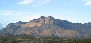
The Guadalupe Mountains are a mountain range located in West Texas and southeastern New Mexico. The range includes the highest summit in Texas, Guadalupe Peak, 8,751 ft (2,667 m), and the "signature peak" of West Texas, El Capitan, both of which are located within Guadalupe Mountains National Park. The Guadalupe Mountains are bordered by the Pecos River valley and Llano Estacado to the east and north, Delaware Mountains to the south, and Sacramento Mountains to the west.
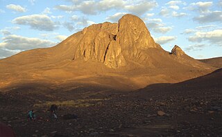
Mount Tahat is the highest mountain peak in Algeria. It sits at an elevation of 2,908 metres. Other sources indicate an elevation of 3,003 metres (9,852 ft). Tahat is also the highest peak in the Hoggar Mountains. Its nearest city is Tamanrasset which is located 56 km to the south.

Mount Uwaynat or Gabal El Uweinat is a mountain range in the area of the Egyptian-Libyan-Sudanese border.

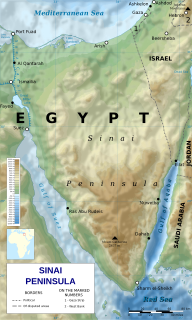
Mount Catherine, locally known as Gabal Katrîne, is the highest mountain in Egypt. It is located near the city of Saint Catherine in the South Sinai Governorate.

Gabal Elba or Elba Mountain is a peak and, in general, includes the associated mountainous area in the Hala'ib Triangle area. Despite being claimed by both Egypt and Sudan, the area is currently under Egyptian control.
Hala'ib, or Halayeb, is a Red Sea port and town, located in the Hala'ib Triangle, a 20,580 km2 (7,950 sq mi) area disputed between Sudan and Egypt. The town lies on the southern tip of what Egyptians refer to as the Red Sea Riviera and the north eastern corner of Sudan's Red Sea State and is near the ruins of medieval ‘Aydhab. De facto control of the area is held by the Egyptian government.

Korab is a mountain range in the eastern corner of Albania and the western part of North Macedonia, running along the border between both countries. It forms also the European Green Belt. In Albania, it is also called Vargu lindor, but this term encompasses mountains further north, such as the Koritnik and Gjallica. The highest peak is Mount Korab at 2,751 m (9,026 ft) above sea level. With a prominence of 2,169 m (7,116 ft), Korab is the 18th most prominent mountain peak in the European continent. The mountains are composed of sedimentary rock, including shale, sandstone, dolomite and limestone. The name refers to a Paleochristian sea god.

The Central Mountain Range is a physiogeographical region encompassing the central and eastern edge of Albania. It comprises the mountainous inland extending all the way from the valley of Drin and the mountains of Sharr, Skanderbeg, Korab, and Shebenik-Jabllanicë, through the lakes of Ohrid and Prespa, until it reaches the village of Ersekë and the mountains of Pindus close to the border between the country and Greece.

Gabal Hagar El Zarqa is the highest point in Bir Tawil, an unclaimed area in the Nubian desert between Egypt and Sudan in Northeast Africa. Due to a long-standing disagreement over the location of that border, its jurisdiction is unclear; it is said by the National Geospatial-Intelligence Agency to be in Egypt. In December 2017 British mountaineer Ginge Fullen accompanied by a local guide summited a point 400 m (1,300 ft) to the east of the waypoint listed on the right, recording a height of 716 m (2,349 ft) at N21 53'01 E33 58'13.