
Uttar Pradesh is a state in northern India. With over 200 million inhabitants, it is the most populated state in India as well as the most populous country subdivision in the world. It was created on 1 April 1937 as the United Provinces of Agra and Oudh during British rule, and was renamed Uttar Pradesh in 1950, giving it the acronym UP. The state is divided into 18 divisions and 75 districts, with the state capital being Lucknow, and Allahabad serving as the judicial capital. On 9 November 2000, a new state, Uttaranchal, was carved from the state's Himalayan hill region. The two major rivers of the state, the Ganges and Yamuna, join at Triveni Sangam in Allahabad and flow further east as Ganges. Other prominent rivers are Gomti and Saryu. The forest cover in the state is 6.1% of the state's geographical area. The cultivable area is 82% of total geographical area and net area sown is 68.5% of cultivable area.

Meerut district, is one of the districts of Uttar Pradesh state of India, and Meerut is the district headquarters. Meerut district is also a part of the Meerut division. The administrative head of district of Meerut is a District Magistrate while the administrative head of Meerut Division is Divisional Commissioner, an IAS officer.
The demographics of Uttar Pradesh is a complex topic, which is undergoing dynamic change. Uttar Pradesh is India's most populous state, and the largest subdivision in the world. It has a population of about 199,812,341 as per the 2011 census. If it were a separate country, Uttar Pradesh would be the world's fifth most populous nation, next only to China, India, the United States of America and Indonesia. Uttar Pradesh has a population more than that of Pakistan. There is an average population density of 828 persons per km² i.e. 2,146 per sq mi. The capital of Uttar Pradesh is Lucknow, and Allahabad serves as the state’s judicial capital. Hindus and Muslims both consider the state as a holy place.

The Uttar Pradesh Legislative Assembly is the lower house of the bicameral legislature of Uttar Pradesh. There are 403 seats in the house filled by direct election using a single-member first-past-the-post system.
Jhansi Nagar is the 223rd constituency of 403 elected constituencies in the Uttar Pradesh Legislative Assembly. It belongs to the general category. It falls under the Jhansi Lok Sabha seat and Jhansi district. The first M.L.A. of Jhansi, Atma Ram Govind Kher was speaker of the Uttar Pradesh assembly three times.

Kasna is a village in Shivgarh block of Rae Bareli district, Uttar Pradesh, India. As of 2011, its population is 1,191, in 222 households. It has one primary school and no healthcare facilities.
Sarai Chhatardhari is a village in Shivgarh block of Rae Bareli district, Uttar Pradesh, India. As of 2011, its population is 1,932, in 351 households. It has one primary school and no healthcare facilities.

Chingahi is a village in Tiloi block of Rae Bareli district, Uttar Pradesh, India. As of 2011, its population is 1,768, in 303 households. It has one primary school and no healthcare facilities.
Bhadmar is a village in Tiloi block of Rae Bareli district, Uttar Pradesh, India. As of 2011, its population is 2,038, in 349 households.
Bhadsana is a village in Tiloi block of Rae Bareli district, Uttar Pradesh, India. As of 2011, its population is 1,862, in 343 households.

Harni is a village in Harchandpur block of Rae Bareli district, Uttar Pradesh, India. As of 2011, its population is 759, in 140 households. It has one primary school and no healthcare facilities.
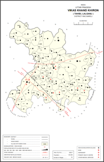
Gonamau is a village in Khiron block of Rae Bareli district, Uttar Pradesh, India. It is located 18 km from Lalganj, the tehsil headquarters. As of 2011, it has a population of 1,247 people, in 228 households. It has one primary school and no healthcare facilities.

Palti Khera is a village in Sareni block of Rae Bareli district, Uttar Pradesh, India. It is located 18 km from Lalganj, the tehsil headquarters. As of 2011, it has a population of 2,641 people, in 523 households. It has one primary school and no healthcare facilities.

Lalumau is a village in Lalganj block of Rae Bareli district, Uttar Pradesh, India. It is located 6 km from Lalganj, the block and tehsil headquarters. As of 2011, it has a population of 1,852 people, in 336 households. It has two primary schools and no healthcare facilities.

Mansukhmau is a village in Dalmau block of Rae Bareli district, Uttar Pradesh, India. It is located 9 km from Dalmau, the block headquarters. As of 2011, it has a population of 394 people, in 65 households. It has no schools and no healthcare facilities.
Sursana is a village in Dalmau block of Rae Bareli district, Uttar Pradesh, India. It is located 8 km from Dalmau, the block headquarters. As of 2011, it has a population of 2,150 people, in 404 households. It has no schools and no healthcare facilities.

Tikaria is a village in Deenshah Gaura block of Rae Bareli district, Uttar Pradesh, India. It is located 30 km from Raebareli, the district headquarters. As of 2011, it has a population of 812 people, in 140 households. It has no schools and no healthcare facilities.

Khaliqpur Kalan is a village in Unchahar block of Raebareli district, Uttar Pradesh, India. It is located 30km from Raebareli, the district headquarters. As of 2011, it has a population of 1,841 people, in 339 households.
