
Chandauli district is a district of Uttar Pradesh state of India, and Chandauli town is the district headquarters. Chandauli district, a part of Varanasi Division, became a separate district on 20 May 1997.
Panchayat samiti or block panchayat is a rural local government (panchayat) body at the intermediate tehsil (taluka/mandal) or block level in India. It works for the villages of the tehsil that together are called a development block. It has been said to be the "panchayat of panchayats".

Panchayati raj is the system of local self-government of villages in rural India as opposed to urban and suburban municipalities.
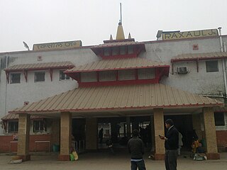
Raxaul is a sub-divisional town in the East Champaran district of the Indian state of Bihar. It is situated at the India-Nepal border with Birgunj city (Nepal). Raxaul is a major railway junction.
Laila is a village in the southern state of Karnataka, India. It is located in the Beltangadi taluk of Dakshina Kannada district.
A tehsil is a local unit of administrative division in India and Pakistan. It is a subdistrict of the area within a district including the designated populated place that serves as its administrative centre, with possible additional towns, and usually a number of villages. The terms in India have replaced earlier terms, such as pargana (pergunnah) and thana.

In India, a Community development block or simply Block is a sub-division of Tehsil, administratively earmarked for planning and development. In tribal areas, similar sub-divisions are called tribal development blocks. The area is administered by a Block Development Officer (BDO), supported by several technical specialists and village-level workers. A community development block covers several gram panchayats, the local administrative units at the village level. A block is a rural subdivision and typically smaller than a tehsil. A tehsil is purely for revenue administration, whereas a block is for rural development purposes. In most states, a block is coterminous with the panchayat samiti area.
Awazapur (Awajapur) is a village panchayat in Chandauli district of Uttar Pradesh, India. It is located 40 km away from Varanasi, and 20 km from Chandauli. The population of the village is above 7000 in this time. In Awazapur, a large number of people are in army, Teacher and defense services. The village has a post office. There are two canals in the village, north and south of the village. The village also has a college named Shahid Captain Vijay Pratap Singh Mahavidyalaya ,Amar sahid vidya mandir Inter college, Amar sahid balika inter college and Petrol Pump, KGSG Bank.
Bidupur is a community development block in the Vaishali district in the Indian state of Bihar. Bidupur is one of the 16 blocks of Vaishali district. There are total 24 Gram Panchayats in bidupur block And There are 116 villages in Bidupur block. Kacchi dargah-Bidupur bridge will become the largest bridge of India in 2024. Bidupur is fastest developing after Hajipur in vaishali.
Block Pramukh is a term used in India to refer to the elected head of a Panchayat Samiti or Block Panchayat. The Panchayat samiti is a tier of the Panchayati raj system. It is a rural local government body at the Tehsil (block) level in India. It works for the villages of the tehsil that together are called a development block. The Panchayat Samiti is the link between the gram panchayat and the zila parishad. There are a number of variations in the name of this institution in the various states. For example, it is known as Kshetra Panchayat in Uttar Pradesh, Mandal Parishad in Andhra Pradesh, Taluka Panchayat in Gujarat, Block Panchayat in Kerala, and Mandal Panchayat in Karnataka.
Rajapur is a village in Mohammadabad Tehsil in Ghazipur District of Uttar Pradesh State, India. It belongs to Varanasi Division. It is located 28 km towards east from District headquarters Ghazipur. Rajapur has total 835 families residing. The Rajapur village has population of 4872 of which 2487 are males while 2385 are females as per Population Census 2011.

Pradhan Khunta is a large village located in Baliapur Block of Dhanbad district, Jharkhand with total 840 families residing.It is located 199M above sea level.

Sakaldiha Assembly constituency is one of the 403 constituencies of the Uttar Pradesh Legislative Assembly, India. It is a part of the Chandauli district and one of the four assembly constituencies in the Chandauli Lok Sabha constituency. First election in this assembly constituency was held in 2008 after constituency came into existence when "Delimitation of Parliamentary and Assembly Constituencies Order, 2008" was passed in the year 2008.
Pipra Dixit is a medium size village in Salempur tehsil of Deoria district Uttar pradesh, India.
Banshipur is a village in Chandauli District in the Indian state of Uttar Pradesh. It comes under Vishunpura panchayat, Block Chahaniya. The nearest Railway station is Sakaldiha, and the nearest metro city is Varanasi. The village is approximately 8 km from the river Ganga.
Karivellur -peralamGrama Panchayat is a Rural Local Body in Payyannur Panchayat Samiti part of Kannur Zila Parishad. There are total 2 Villages under Karivellur -peralam Gram Panchayat jurisdiction. Gram Panchayat is further divided into 14 Wards. The panchayat has total 12 elected members by people. This Gram Panchayat has total 12 schools.
Kaludi is a village in Pachpadra tehsil of Balotra district in Rajasthan, India. As of the 2011 India census, the total population of the village is 2876.
Majivala village in Pachpadra tehsil of Balotra district in Rajasthan, India. As of the 2011 India census, the total population of the village is 5882.

Dudhiya is a village in Baliapur of Dhanbad district in Jharkhand, India.
Faizpur Ninana is a village, popularly known as Village of Martyrs, located in the Baghpat Block of Baghpat District in the state of Uttar Pradesh, India. It is part of the Meerut Division and lies approximately 10 kilometers north of the district headquarters, Baghpat. The village is situated at an elevation of 229 meters above sea level and is positioned near the Haryana state border, adding to its strategic significance.


