Gaillard, Georgia

Last updated

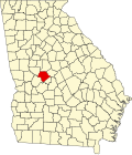
Gaillard is an unincorporated community in Crawford County, in the U.S. state of Georgia. [1]

Contents

History

A post office called Gaillard was established in 1903, and remained in operation until 1951. [2] The community was named after a local surveyor. [3]

Decline

Gaillard was a railroad community that died after the closure of the rail line. [4]

Related Research Articles

<span class="mw-page-title-main">Crawford County, Georgia</span> County in Georgia, United States

Crawford County is a county located in the central portion of the U.S. state of Georgia. As of the 2020 census, the population was 12,130. The county seat is Knoxville.

<span class="mw-page-title-main">Roberta, Georgia</span> City in Georgia, United States

Roberta is a city in Crawford County, Georgia, United States. The population was 1,007 at the 2010 census. It is part of the Macon metropolitan statistical area.

<span class="mw-page-title-main">Waverly Hall, Georgia</span> Town in Georgia, United States

Waverly Hall is a town in Harris County, Georgia, United States. It is part of the Columbus, Georgia-Alabama metropolitan statistical area. The population was 638 in 2020.

<span class="mw-page-title-main">Culloden, Georgia</span> City in Georgia, United States

Culloden is a city in Monroe County, Georgia, United States. The population was 200 in the 2020 census. It is part of the Macon metropolitan statistical area.

<span class="mw-page-title-main">Hayes Township, Clare County, Michigan</span> Civil township in Michigan, United States

Hayes Township is a civil township of Clare County in the U.S. state of Michigan. The population was 4,642 at the 2020 census.

Upatoi is a community in northeastern Muscogee County, Georgia, United States. Upatoi was annexed by the city of Columbus, Georgia, in 1971 as part of the consolidation of the city and county governments. The community is on Georgia Route 22 and U.S. Route 80 approximately 15 miles east of Columbus. Upatoi Creek is on the southern boundary of Muscogee County approximately three miles south of the community. The ZIP Code for Upatoi is 31829.

<span class="mw-page-title-main">Blanchard, Ohio</span> Unincorporated community in Ohio, U.S.

Blanchard is an unincorporated community in Hardin County, in the U.S. state of Ohio.

Meeker is an unincorporated community in Marion County, in the U.S. state of Ohio. Meeker is served by Ridgedale Local School District.

Cornelia is an unincorporated community in southern Johnson County, in the U.S. state of Missouri.

Atwater is an unincorporated community in Upson County, in the U.S. state of Georgia.

Brent is an unincorporated community in Monroe County, in the U.S. state of Georgia.

Chalybeate Springs is an unincorporated community in Meriwether County, in the U.S. state of Georgia.

Francisville is an unincorporated community in Crawford County, in the U.S. state of Georgia.

Hammett is an unincorporated community in Crawford County, in the U.S. state of Georgia.

Harris City is an unincorporated community in Meriwether County, in the U.S. state of Georgia.

Lee Pope is an unincorporated community in Crawford County, in the U.S. state of Georgia.

Raleigh is an unincorporated community in Meriwether County, in the U.S. state of Georgia.

Strouds is an unincorporated community in Monroe County, in the U.S. state of Georgia.

White Sulphur Springs is an unincorporated community in Meriwether County, in the U.S. state of Georgia.

Ypsilanti is an unincorporated community in Talbot County, in the U.S. state of Georgia.

References

  1. U.S. Geological Survey Geographic Names Information System: Gaillard, Georgia
  2. "Post Offices". Jim Forte Postal History. Retrieved 30 December 2018.
  3. Krakow, Kenneth K. (1975). Georgia Place-Names: Their History and Origins (PDF). Macon, GA: Winship Press. p. 91. ISBN   0-915430-00-2.
  4. "Q&A with Victoria Simmons author of "Vanished Towns Revisited: Crawford County and Byron, Georgia"". The Telegraph. 2015-05-28. Retrieved 2023-02-27.

32°38′37″N84°00′19″W / 32.64361°N 84.00528°W / 32.64361; -84.00528