Raichur District is an administrative district in the Indian state of Karnataka. It is located in the northeast part of the state and is bounded by Yadgir district in the north, Bijapur and Bagalkot district in the northwest, Koppal district in the west, Bellary district in the south, Jogulamba Gadwal district of Telangana and Kurnool district of Andhra Pradesh in the east.

The Tungabhadra River is a river in India that starts and flows through the state of Karnataka during most of its course, before flowing along the border between Telangana, Andhra Pradesh and ultimately joining the Krishna River near Gundimalla village in Jogulamba Gadwal district of Telangana.
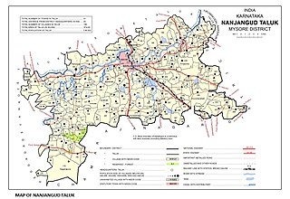
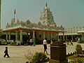
Nanjangud, officially known as Nanjanagudu, is a town in the Mysuru district of Indian state of Karnataka. Nanjangud lies on the banks of the river Kapila, 23 km from the city of Mysore. Nanjangud is famous for the Srikanteshwara Temple located here. Nanjangud is also called Dakshina Kashi. This town is also famous for a type of banana grown in the region called the Nanjanagoodu rasabale. Nanjangud's local administrative unit was designated as a Municipal Committee in 2015 by including Devirammanahalli and Kallahalli village.

Shimoga district, officially known as Shivamogga district, is a district in the Karnataka state of India. A major part of Shimoga district lies in the Malnad region or the Sahyadri. Shimoga city is its administrative centre. Jog Falls view point is a major tourist attraction. As of 2011 Shimoga district has a population of 17,52,753. There are seven taluks: Soraba, Sagara, Hosanagar, Shimoga, Shikaripura, Thirthahalli, and Bhadravathi. Channagiri and Honnali were part of Shimoga district until 1997 when they became part of the newly formed Davanagere district.

Hornadu, also known as Horanadu, is a Hindu holy locale and also a jain holy centerPanchayat village located in kalasa taluk of Chikkamagaluru district, Karnataka, India. The deity at the Annapoorneshwari Temple at Hornadu is Annapurneshwari. The main deity of the goddess was put in place by Adi Shankaracharya; the new deity of goddess Annapurneshwari was consecrated in the temple in 1973. Horanadu has an elevation of 831 m (2,726 ft)
Siruguppa is a city and headquarters of the Siruguppa taluk and second largest city in Ballari district after Hospete carved out of Ballari district of Indian state of Karnataka.

Hosahali is one of twin-villages Mattur-Hosahali, on the banks of the Tunga River in Karnataka state, southern India. It lies in an agricultural region where the main crop is the Areca nut. It is known for Sanskrit, Veda, Gamaka (story-telling) and Sangeetha Padma Shri awardee HR Keshavamurthy is also from this village. From above, the village appears as a "Paa Ni Pee Tha". The village is situated a little over 5 km from Shimoga city and around 4 km from Gajanur Tunga Anicut (dam).
Lingadahalli is a village in Tarikere Taluk, Chikkamagaluru district, Karnataka, India. Lingadahalli is one of the prominent pre-historic sites in Karnataka state.
Gandhinagar is the capital city of the Indian state of Gujarat.

Thrikkadavoor is a town and a neighbourhood of Kollam city in the state of Kerala, India. It is located approximately 5 kilometres north of Kollam city centre and 30 kilometres away from Paravur, Thrikkadavoor has become a bustling urban center, and is now home to educational institutions, five star hotel, local business establishments and major recent real estate ventures
Thrikkadavoor was a separate panchayath till 2015. In May 2015, Government of Kerala have decided to expand City Corporation of Kollam by merging Thrikkadavoor panchayath.
Gorebal is a village located 9 km from Sindhanur in the Raichur district of Karnataka state, India. Gorebal is well irrigated with Tunga Bhadra left bank canals 32 and 36.
Kandagallu is a village in Davangere taluk, Karnataka, South India. The population is approximately 5,000
Gurgunta also spelled as Guragunta is a village in the northern state of Karnataka, India. Gurgunta is famous for the ancient Amareshwara temple. It is located in the Lingasugur taluk of Raichur district in Karnataka. Karnataka National highway 150A passes through the village. This village is just 10 km away from Hutti Gold Mines, the unique primary gold producing company. This is also one of the hobli centre in Lingasugur taluka. This village consists of number of folds. most of the lands have been irrigated. Paddy is the major crop grown here. Remaining Non irrigated lands are grown by sun flower, cotton, toor, jawar etc. Major occupation is agriculture and small business. Huts and Mud roof houses are being replaced by RCC buildings. The famous Religious place Sri Gudagunti Amareshwara Temple is located near Gurgunta village. Before independence, Gurgunta was ruled by the Nayaka kings from 1636 to 1948. Around 16 Nayaka rulers have been ruled this state. In memory of this old fort and palace can be seen. This village consists of Grama Panchayat, Govt. P.U. College, High School, Primary School, RSK, Primary Health Centre, Veterinary dispensary, and hostel. Lord Venkateshwara Temple is located in the village. Navaratri Utsava (DASARA) is celebrated very nice. 9 days will be fully engaged in Bhajana and Purana functions. Moharam festival is also one of the famous festivals celebrated in the village. Gundlabandi Halla falls is small falls nearby 4 km. Tinthini Mouneshwara Temple is a religious and pilgrim place located near 20 km from Gurgunta. Though this village is not having bus stand and daily travelling passengers suffering a lot during summer and rainy season.
Sirwar, also spelled as Sirawara, is a new taluk of Raichur district in Karnataka state, India. Sirwar is one of the fastest-growing towns in Karnataka. It is famous for Paddy, Sona Mossurie Rice is one of the best quality rices in the world. It is the business center for almost 30 villages across the region. It is also famous for its litchi, which it exports in tones.
Thirukkalambur is a village located in Pudukkottai District of Tamil Nadu. It is approximately 80 km from Thiruchirapalli (Trichy) and 40 km from Pudukkottai. The nearest towns are Ponnamaravathy and Singampunari.
Behera(; is a hill town and Gram Panchayat of Dharamgarh Tehsil.It is 20 km from Dharamgarh and 14 km from Athara-Nala forest. Behera Dam is situated nearby which is 18 km from the village. This small hill town is surrounded by forests and is situated nearly to a very well known tourist place Dokrichanchra of Kalahandi. Behera is 65 km distance from its District Main City Bhawanipatna, and 560 km distance from its State Capital Bhubaneswar.
Pothnal is a village in the Manvi taluk of Raichur district in the Indian state of Karnataka. Pothnal is well connected by road and it lies on Karnataka State highway 23. Pothnal is 22 km from Manvi and 24 km from Sindhanur. it is a well developing village because it lies on the bank of a nala called pothnal nala. it has nearly 10 schools and two three pu and degree colleges. and also has diploma college. HUCHCHABUDDESHWARA temple is very famous and it has jatra in every August. Nearest major railway station is in Raichur.pothnal has two NGO's one is vimukthi charitable trust and one is Navanirmana trust.
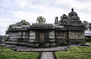
The Rameshvara temple is a 12th-century Shiva temple in Kudli, Shimoga district, Karnataka India. It is an early non-ornate, Hoysala construction with simpler Vesara style. The village of Koodli – also spelled Kudli, Kudali – was a major town through the 14th-century and of great antiquity, with ruins of over eight major Hindu temples and monasteries. It is located about 18 kilometres (11 mi) north-east of Shimoga city, the district headquarters. The town gets its name because it is situated at the confluence of the Tunga and Bhadra tributaries that form the Tungabhadra river.
Challur is a village in the Karatagi taluk of Koppal district in the southern state of Karnataka, India. Challur is situated near Karatagi.