
The Raichur Doab is a Doab, in this case the triangular region of land in the southern Indian states of Telangana and Karnataka lying between the Krishna River and its tributary, the Tungabhadra River. The doab is named for the town of Raichur in the Raichur District. The Raichur Doab is considered to be very fertile because of the sediments carried by Krishna and Tungabhadra rivers. The doab includes Raichur district and Koppal district in Karnataka, and Gadwal district in Telangana. Some areas of Raichur doab also called as Nadigadda region became a part of Telangana during Andhra Pradesh Reorganisation Act in 2014.Those areas are Gadwal, Alampur and Maganoor. Gadwal is one of the 31 districts of Telangana State.

Raichur District is an administrative district in the Indian state of Karnataka. It is located in the northeast part of the state and is bounded by Yadgir district in the north, Bijapur and Bagalkot district in the northwest, Koppal district in the west, Bellary district in the south, Jogulamba Gadwal district of Telangana and Kurnool district of Andhra Pradesh in the east.
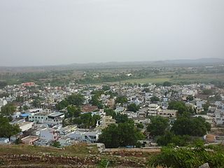
Manvi is a City in the Raichur district of the Indian state of Karnataka. It is the municipal headquarters of the Manvi taluk. Manvi Police Station stood fifth in the list of top 10 best police station across the country.

Kalaburagi district, formerly known as Gulbarga district, is one of the 31 districts of Karnataka state in southern India. Kalaburagi city is the administrative headquarters of the district. The district is the headquarters of Kalaburagi division.

North Karnataka is a geographical region in Deccan plateau from 300 to 730 metres elevation that constitutes the region of the Karnataka state in India and the region consists of 13 districts. It is drained by the Krishna River and its tributaries the Bhima, Ghataprabha, Malaprabha, and Tungabhadra. North Karnataka lies within the Deccan thorn scrub forests ecoregion, which extends north into eastern Maharashtra.

Raichur is a city and headquarters of eponymous Raichur district in the Karnataka state of India. Raichur, located between Krishna and Tungabhadra rivers.
Yadgiri is a city and the administrative headquarters of Yadgir district in the Indian state of Karnataka. It is also the administrative headquarters of Yadgir Taluka, one of the six taluks of Yadgir.
Hutti Gold Mines, also spelled Hatti, is a notified area council in Raichur district in the Indian state of Karnataka. The mines are owned and operated by Hutti Gold Mines Limited.
Mudgal is a Municipal town in Lingsugur taluk, Raichur district in the Indian state of Karnataka. Mudgal is about 10 miles south-west of Lingsugur.
Tekkalakote, also known as Tekkalakota, is a Panchayat town and Pre-historic Neolithic site in Siruguppa taluk of Ballari district in the Indian state of Karnataka.

Maski is a town and an archaeological site in the Raichur district of the state of Karnataka, India. It lies on the bank of the Maski river which is a tributary of the Tungabhadra. Maski derives its name from Mahasangha or Masangi. The site came into prominence with the discovery of a minor rock edict of Emperor Ashoka by C. Beadon in 1915. It was the first edict of Emperor Ashoka that contained the name Ashoka in it instead of the earlier edicts that referred him as Devanampiye piyadasi. This edict was important to conclude that many edicts found earlier in the Indian sub-continent in the name of Devanampiye piyadasi, all belonged to Emperor Ashoka. The edict is etched on a rock-face of Durgada-gudda, one of the gneissic outcrops that are present in the site.
Buddhism in Northern Karnataka has seen major development after the discovery of an Ashoka inscription at Maski in Raichur District a few decades ago and of a Buddhist settlement through a series of archaeological excavations at Sannati which have shed light on the historic significance of Karnataka.
Gabbur also spelled as Gabburu is a village in the southern state of Karnataka, India. It is located in the Devadurga taluk of Raichur district in Karnataka.
Kavital is a town in the Sirwar taluk of Raichur district in Karnataka state, India. Kavital is 60 km west to the district headquarters Raichur and 35 km north to the taluka headquarters Manvi. Kavital lies on Karnataka State Highway 20. Nearest towns are Lingasugur and Raichur.
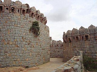
Kyadigera is a village in Devadurga taluk of Raichur district in the Indian state of Karnataka. Kyadigera was part of Shorapur kingdom and has an ancient fort. Kyadigera lies between Sirwar and Arakera.
Advibhavi (Mudgal) is a village in the southern state of Karnataka, India. It is located in the Lingsugur taluk of Raichur district in Karnataka.

Yadgir District is one of the 31 districts of Karnataka state in southern India.This district was carved out of Kalaburagi district as the 30th district of Karnataka on 10 April 2010. Yadgir town is the administrative headquarters of the district. The district occupies an area of 5,160.88 km2 (1,992.63 sq mi).
Piklihal is a village near Mudgal in the Lingasugur taluk of Raichur district in Karnataka state, India. Piklihal is a neolithic period site. The site was excavated by F. Raymond Allchin in 1952. Piklihal is 6 km south to Mudgal town. The Neolithic settlers in piklihal were cattle herders; they domesticated cattle, sheep, goats etc. They set up seasonal camps surrounded by cowpens made with posts stakes.
Venkatapura is a village near Maski in the Lingasugur taluk of Raichur district in the Indian state of Karnataka. Venkatapura is a neolithic period site. 45 Cairns were found in the hills south to the village. Some of these cairns are 50 meters in diameter. Some are found in rings and pairs. Venkatapura is 5 km from Maski town.
Watgal also spelled as Vatagal is a village near Kavital in the Manvi taluk of Raichur district in the Indian state of Karnataka. Watgal is the location of a pre-historic period site. Baswanna Tempal Neolithic grey ware of Brahmagiri fabric and Jorwe fabric has been excavated in the village. Watgal is lies between Kavital and Lingasugur.

