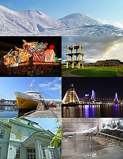
Aomori is the capital city of Aomori Prefecture, in the Tōhoku region of Japan. As of 1 April 2020, the city had an estimated population of 278,964 in 136,457 households, and a population density of 340 people per square kilometer spread over the city's total area of 824.61 square kilometers (318.38 sq mi). Aomori is one of Japan's 60 core cities and the core of the Aomori metropolitan area.

Aomori Prefecture is a prefecture of Japan in the Tōhoku region. The prefecture's capital, largest city, and namesake is the city of Aomori. Aomori is the northernmost prefecture on Japan's main island, Honshu, and is bordered by the Pacific Ocean to the east, Iwate Prefecture to the southeast, Akita Prefecture to the southwest, the Sea of Japan to the west, and Hokkaido across the Tsugaru Strait to the north. Aomori Prefecture is the 8th-largest prefecture, with an area of 9,645.64 km2 (3,724.20 sq mi), and the 31st-most populous prefecture, with more than 1.2 million people. Approximately 45 percent of Aomori Prefecture's residents live in its two core cities, Aomori and Hachinohe, which lie on coastal plains. The majority of the prefecture is covered in forested mountain ranges, with population centers occupying valleys and plains. Aomori is the third-most populous prefecture in the Tōhoku region, after Miyagi Prefecture and Fukushima Prefecture. Mount Iwaki, an active stratovolcano, is the prefecture's highest point, at almost 1,624.7 m (5,330 ft).

Shirakawa is a city located in Fukushima Prefecture, Japan. As of 1 April 2020, the city had an estimated population of 59,393 in 23,546 households and a population density of 190 persons per km2. The total area of the city was 305.3 square kilometres (117.9 sq mi).

Hiraizumi is a town located in Nishiiwai District, Iwate Prefecture, Japan. As of 30 April 2020, the town had an estimated population of 7,408 and a population density of 120 inhabitants per square kilometre (310/sq mi) in 2,616 households. The total area of the town was 63.39 km2 (24.48 sq mi). It is noted for the Historic Monuments and Sites of Hiraizumi, which achieved UNESCO World Heritage Site status in 2011.

Ichinohe is a town located in Iwate Prefecture, Japan. As of 1 April 2020, the town had an estimated population of 12,053, and a population density of 40 persons per km² in 5645 households. The total area of the town is 300.03 square kilometres (115.84 sq mi).

Hiranai is a town located in Aomori Prefecture, Japan and a part of the Aomori metropolitan area. As of 1 October 2021, the town had an estimated population of 10,460 in 4,860 households, and a population density of 48 persons per km². It is the most heavily populated town in Higashitsugaru District. The total area of the town is 217.09 km2 (83.82 sq mi).

Shichinohe is a town located in Aomori Prefecture, Japan. As of 1 April 2020, the town had an estimated population of 15,286, and a population density of 45 persons per km2, in 6,797 households. The total area of the town is 337.23 square kilometers (130.21 sq mi).

The Five Routes, sometimes translated as "Five Highways", were the five centrally administered routes, or kaidō, that connected the de facto capital of Japan at Edo with the outer provinces during the Edo period (1603–1868). The most important of the routes was the Tōkaidō, which linked Edo and Kyoto. Tokugawa Ieyasu started the construction of these five routes to increase his control over the country in 1601, but it was Tokugawa Ietsuna, the 4th shōgun of the Tokugawa shogunate and Ieyasu's great-grandson, who declared them as major routes. Post stations were set up along the route for travelers to rest and buy supplies. The routes thrived due to the policy of sankin-kōtai, that required the daimyō to travel in alternate years along the routes to Edo.
National Route 4 is a major national highway in eastern Honshū, Japan. Measuring 738.5-kilometer-long (458.9 mi) it is the longest highway in the country. When oversea routes are included, it is the second longest highway in Japan, with National Route 58 then measuring 884.4 kilometers (549.5 mi) because of its maritime sections. The highway connects Tokyo and Aomori via Utsunomiya, Kōriyama, Sendai, and Morioka.

National Route 7 is a major north-south national highway on the Sea of Japan side of the island of Honshū, Japan. It traverses four prefectures, with Niigata at its southern end, then Yamagata, Akita, and finally, Aomori at its northern end. The 471.8-kilometer (293.2 mi) long highway begins at an intersection with national routes 8, 17, 113, 116, 289, 350, and 402 in the capital of Niigata, Niigata. Travelling north, the highway links the prefectural capitals Akita and Aomori. In central Aomori the highway ends at the northern terminus of National Route 4 and National Route 45.
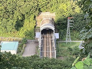
The Hakkōda Tunnel is a 26.445-kilometer-long (16.432 mi) railway tunnel located in central Aomori Prefecture, in the Tōhoku region of Japan. It passes through the Hakkōda mountain range and links the town of Shichinohe with the city of Aomori.

Morioka Castle is a hirayama-style Japanese castle constructed in 1611. It was the seat of the Nanbu clan, a tozama daimyō clan who ruled over Morioka Domain, Mutsu Province in the Tōhoku region of northern Japan during the Edo period Tokugawa shogunate. The castle is located in what is now the center of the city of Morioka, Iwate Prefecture, Japan. It was also referred to as Kozukata Castle, but strictly speaking this name pertains to the predecessor of Morioka Castle on the same site.
The Ōshū Kaidō (奥州街道) was one of the five routes of the Edo period. It was built to connect Edo with Mutsu Province and the present-day city of Shirakawa, Fukushima Prefecture, Japan. It was established by Tokugawa Ieyasu for government officials traveling through the area.
The Matsumaedō (松前道) was the continuation of the Ōshū Kaidō, one of the Edo Five Routes of Japan. It connected the Sendaidō's terminus at Sendai Castle with the northern tip of modern-day Aomori Prefecture. It was established by Tokugawa Ieyasu for government officials traveling through the area. The route is named after the Matsumae Domain, the only Edo period feudal domain to have been located in Ezo ; Matsumae was accessible by boat from the northern terminus of the Matsumaedō.
National Route 101 is a national highway of Japan connecting the capitals of Aomori and Akita prefectures, Aomori and Akita in northern Japan, with a total length of 241.6 kilometers (150.1 mi). The majority of the highway travels along the coast of the Sea of Japan, paralleling the more inland National Route 7. The present-day highway largely follows the path of the Ōmagoe-kaidō, an Edo period road that linked the Kubota and Hirosaki feudal domains.
National Route 119 is a national highway located entirely within Tochigi Prefecture, Japan. It connects the city of Nikkō to Utsunomiya, the prefecture's capital, and has a total length of 63.9 kilometers (39.7 mi). The present-day highway largely follows the path of the Nikkō Kaidō, an Edo period road that linked Edo and the Shrines and Temples of Nikkō.

National Route 280 is a national highway of Japan that traverses the prefectures, Aomori and Hokkaido as well as the Tsugaru Strait that separates them. It currently is made up of two sections that travel 150.7 kilometres (93.6 mi) from Aomori, north across the Tsugaru Peninsula to Sotogahama where the first section ends at the site of a former ferry to across the Tsugaru Strait to the town, Fukushima. The other section begins at the corresponding former ferry terminal in Fukushima. The road then travels alongside the southern coast of Hokkaido concurrently with National Route 228 to Hakodate where the route meets its northern terminus.

Sannohe Castle was a Muromachi period Japanese castle located in what is now the town of Sannohe, in Sannohe District of Aomori Prefecture, in the Tōhoku region of far northern Japan. It was located on a river terrace of the Mabechi River, which formed part of its natural defenses.

Nonai was a village located in Higashitsugaru District in central Aomori Prefecture, Japan. The former town was best known as a shukuba along the Matsumaedō and the site of an onsen town, Asamushi Onsen. It is now a neighborhood of the city, Aomori.

Nogiwa Park is an urban park in the western part of the city of Aomori, Japan. Major features of the park include a reservoir, various decorative trees, wetlands, several footbridges, and an observatory.


