Garden Grove, Florida

Last updated

Garden Grove, Florida
Garden Grove, Florida(US 41 North).jpg
US 41 northbound as it enters Garden Grove
USA Florida location map.svg
Red pog.svg
Garden Grove
Usa edcp location map.svg
Red pog.svg
Garden Grove
Coordinates: 28°28′50″N82°26′6″W / 28.48056°N 82.43500°W / 28.48056; -82.43500
Country United States
State Florida
County Hernando
Area
[1]
  Total0.98 sq mi (2.53 km2)
  Land0.97 sq mi (2.51 km2)
  Water0.01 sq mi (0.02 km2)
Elevation
95 ft (29 m)
Population
 (2020)
  Total776
  Density800.83/sq mi (309.29/km2)
Time zone UTC-5 (Eastern (EST))
  Summer (DST) UTC-4 (EDT)
FIPS code 12-25475 [2]
GNIS feature ID0282923

Garden Grove (also known as Garden Grove Estates) is an unincorporated community and census-designated place (CDP) in the U.S. state of Florida, in central Hernando County. The ZIP Code for this community is 34604. As of the 2010 census, Garden Grove had a population of 674. [2]

Contents

Geography

Garden Grove is in southern Hernando County and is bordered by Masaryktown to the south, South Brooksville to the north, and Spring Hill to the west. Garden Grove is located along the eastern edge of Hernando County Airport and is dominated by US 41, the main road through the community.

Though they list their address as being Brooksville, Garden Grove is the headquarters of the Southwest Florida Water Management District which is across from The Trails of Rivard Golf and Country Club.

Demographics

Historical population
CensusPop.Note
2020 776
U.S. Decennial Census [3]

Transportation

The main road through Garden Grove is U.S. 41, which runs southwest to northeast from Masaryktown through Brooksville, the Hernando County seat. The CSX Brooksville Subdivision runs along the east side of the road, and contains a spur to the airport, which was revived when US 41 was widened. Two other roads run from west to east; the first is County Road 574 (Spring Hill Drive), which runs along the northern border of Hernando County Airport before terminating at US 41. The other, County Road 572 (Powell Road), runs along the northern edge of Garden Grove and spans from near Weeki Wachee to Spring Lake.

Related Research Articles

<span class="mw-page-title-main">Citrus County, Florida</span> County in Florida, United States

Citrus County is a county located on the west central coast of the U.S. state of Florida. As of the 2020 census, the population was 153,843. Its county seat is Inverness, and its largest community is Homosassa Springs.

<span class="mw-page-title-main">Hernando County, Florida</span> County in Florida, United States

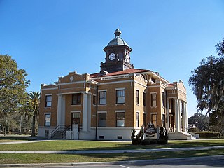
Hernando County is a county located on the west central coast of the U.S. state of Florida. As of the 2020 census, the population was 194,515. Its county seat is Brooksville, and its largest community is Spring Hill.

<span class="mw-page-title-main">Pasco County, Florida</span> County in Florida, United States

Pasco County is located on the west central coast of the U.S. state of Florida. According to the 2020 census, the population was 561,691. Its county seat is Dade City, and its largest city is Zephyrhills. The county is named after Samuel Pasco.

<span class="mw-page-title-main">Hernando, Florida</span> Census-designated place in Florida, US

Hernando is a census-designated place in Citrus County, Florida, United States. The population was 9,054 at the 2010 census. At one time it was a city but it was disincorporated in the 1970s.

<span class="mw-page-title-main">Bayport, Florida</span> Census-designated place in Florida, United States

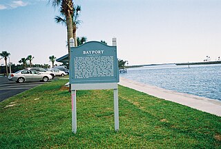
Bayport is an unincorporated community and census-designated place (CDP) in Hernando County, Florida, United States. The population was 43 at the 2010 census.

<span class="mw-page-title-main">Hernando Beach, Florida</span> Census-designated area in Hernando County Florida, United States

Hernando Beach is a census-designated place (CDP) in Hernando County, Florida, United States. The population was 2,299 at the 2010 census.

<span class="mw-page-title-main">Masaryktown, Florida</span> Census-designated place in Florida, United States

Masaryktown is an unincorporated community and census-designated place (CDP) in Hernando County, Florida, United States. The population was 1,077 at the 2020 census. It is named after the first president of Czechoslovakia, Tomáš Garrigue Masaryk.

<span class="mw-page-title-main">Nobleton, Florida</span> Census-designated place in Florida, United States

Nobleton is an unincorporated community and census-designated place (CDP) in Hernando County, Florida, United States. The population was 282 at the 2010 census, up from 160 at the 2000 census.

<span class="mw-page-title-main">North Brooksville, Florida</span> Census-designated place in Florida, United States

North Brooksville is a census-designated place (CDP) in Hernando County, Florida, United States. The population was 3,544 at the 2010 census. It is a suburb included in the Tampa-St. Petersburg-Clearwater, Florida Metropolitan Statistical Area.

<span class="mw-page-title-main">North Weeki Wachee, Florida</span> Census-designated place in Florida, United States

North Weeki Wachee is a census-designated place (CDP) in Hernando County, Florida, United States. The population was 8,524 at the 2010 census, up from 4,253 at the 2000 census.

<span class="mw-page-title-main">Ridge Manor, Florida</span> Census-designated place in Florida, United States

Ridge Manor is a census-designated place (CDP) in Hernando County, Florida, United States. The population was 4,513 at the 2010 census.

<span class="mw-page-title-main">South Brooksville, Florida</span> Census-designated place in Florida, United States

South Brooksville is a census-designated place (CDP) in Hernando County, Florida, United States. The population was 4,007 at the 2010 census. It is a suburb included in the Tampa-St. Petersburg-Clearwater, Florida Metropolitan Statistical Area.

<span class="mw-page-title-main">Spring Hill, Florida</span> Census-designated place in Hernando County Florida, United States

Spring Hill is a census-designated place (CDP) in Hernando County, Florida, United States. The population was 113,568 at the 2020 census, up from 98,621 at the 2010 census. Spring Hill belongs to Florida's Nature Coast region and is in the Tampa-St. Petersburg-Clearwater metro area. It is east of Hernando Beach, southwest of Brooksville, and north of Tampa.

<span class="mw-page-title-main">Spring Lake, Florida</span> Census-designated place in Florida, United States

Spring Lake is an unincorporated community and census-designated place (CDP) in Hernando County, Florida, United States. The population was 458 at the 2010 census, up from 327 at the 2000 census.

<span class="mw-page-title-main">Florida State Road 50</span> Highway in Florida

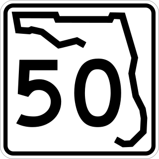
State Road 50 runs across the center of the U.S. state of Florida through Orlando, with its termini at SR 55 at Weeki Wachee and SR 5 in Titusville.

<span class="mw-page-title-main">U.S. Route 41 in Florida</span> Highway in Florida

U.S. Highway 41 (US 41) in the state of Florida is a north–south United States Highway. It runs 479 miles (771 km) from Miami in South Florida northwest to the Georgia state line north of the Lake City area. Within the state, US 41 is paralleled by Interstate 75 (I-75) all the way from Miami to Georgia, and I-75 has largely supplanted US 41 as a major highway.

<span class="mw-page-title-main">U.S. Route 98 in Florida</span> Highway in Florida

U.S. Route 98 is a major east-west thoroughfare through the U.S. state of Florida. Spanning 670.959 miles (1,079.804 km), it connects Pensacola and the Alabama/Florida state line to the west with Palm Beach and the Atlantic coast in the east. It is the longest US road in Florida, as well as the longest US road in any state east of the Mississippi River.

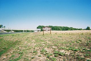
Wiscon is an unincorporated community and census-designated place in Hernando County, Florida, United States. Its population was 681 as of the 2020 census. Florida State Road 50 passes through the community.

References

  1. "2020 U.S. Gazetteer Files". United States Census Bureau. Retrieved October 31, 2021.
  2. 1 2 "Geographic Identifiers: 2010 Demographic Profile Data (G001): Garden Grove CDP, Florida". American Factfinder. U.S. Census Bureau. Retrieved April 26, 2017.[ dead link ]
  3. "Census of Population and Housing". Census.gov. Retrieved June 4, 2016.