Gardiner, Washington | |
---|---|
Coordinates: 48°03′00″N122°54′51″W / 48.05000°N 122.91417°W | |
Country | United States |
State | Washington |
County | Jefferson |
Time zone | UTC-8 (Pacific (PST)) |
• Summer (DST) | UTC-7 (PDT) |
Area code | 360 |
Gardiner is an unincorporated community in Jefferson County, Washington, United States. [1] Additionally, part of Clallam County, located along the Jefferson County line adjacent to Gardiner is often referred to as being part of Gardiner.
Timber in the area was originally cleared in the late 19th century, as was much of Discovery Bay, and was planted with fruit trees – primarily apples and pears. Gardiner took the name of the original farmer, Herbert Gardner. [2] The spelling was eventually changed to its current form, due to a conflict with another Gardner, Washington; this was needed to enable mail delivery. Gardiner lost its post office in the 1990s and residents were given mailing addresses in Sequim, Washington.
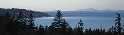
Gardiner is located on the Miller Peninsula, at the northern coast of the Olympic Peninsula on Discovery Bay, which enters the Strait of Juan de Fuca. Gardiner is primarily a rural-residential community, with mostly five- and 20-acre (81,000 m2) parcels, plus several large landholders. Gardiner also has a few retail establishments, a community center, and a church, all located on U.S. Route 101. There is still some farming, lumbering, and fishing, but the area is following the Jefferson County trend away from agriculture, as old homesteads and family farms get subdivided into residences.
The community has roughly 300 people, and is located 12 miles (19 km) east of Sequim, just north of U.S. Route 101.
Gardiner has a public boat ramp that provides access to Discovery Bay; the ramp is maintained by the Port of Port Townsend. Popular salmon fishing derbies are held here each February; in the 2011 event, 760 ticket holders fished in an area spanning 500 square miles. [3]
Jefferson County is a county located in the U.S. state of Washington. As of the 2020 census, the population was 32,977. The county seat and only incorporated city is Port Townsend. The county is named for Thomas Jefferson.
Clallam County is a county in the U.S. state of Washington. As of the 2020 census, the population was 77,155, with an estimated population of 77,616 in 2023. The county seat and largest city is Port Angeles; the county as a whole comprises the Port Angeles, WA Micropolitan Statistical Area. The name is a Klallam word for "the strong people". The county was formed on April 26, 1854. Located on the Olympic Peninsula, it is south from the Strait of Juan de Fuca, which forms the Canada–US border, as British Columbia's Vancouver Island is across the strait.
Blyn is a census-designated place (CDP) in Clallam County, Washington, United States. The population was 101 at the 2010 census, down from 162 at the 2000 census. It is located near the city of Sequim on the shores of Sequim Bay. The area includes the Jamestown S'Klallam Indian Reservation, established in 1874 by the Jamestown S'Klallam Tribe, who named their community Jamestown after their leader; Lord James Balch.
Forks, also previously known as the unincorporated town of Quillayute, is a city in southwest Clallam County, Washington, United States. The population was 3,335 at the 2020 census. It is named after the forks in the nearby Bogachiel, Calawah, and Sol Duc rivers which join to form the Quillayute River.
Sequim is a city in Clallam County, Washington, United States. It is located along the Dungeness River near the base of the Olympic Mountains. The 2020 census counted a population of 8,018, with an estimated population in 2022 of 8,319.
Port Hadlock-Irondale is a census-designated place (CDP) in Jefferson County, Washington, United States. The population was 3,983 at the 2020 census.
Port Townsend is a city on the Quimper Peninsula in Jefferson County, Washington, United States. The population was 10,148 at the 2020 United States Census. It is the county seat and only incorporated city of Jefferson County.
The Olympic Peninsula is a large arm of land in Western Washington that lies across Puget Sound from Seattle, and contains Olympic National Park. It is bounded on the west by the Pacific Ocean, the north by the Strait of Juan de Fuca, and the east by Hood Canal. Cape Alava, the westernmost point in the contiguous United States, and Cape Flattery, the northwesternmost point, are on the peninsula. Comprising about 3,600 square miles (9,300 km2), the Olympic Peninsula contained many of the last unexplored places in the contiguous United States. It remained largely unmapped until Arthur Dodwell and Theodore Rixon mapped most of its topography and timber resources between 1898 and 1900.
Olympic National Forest is a U.S. National Forest located in Washington, USA. With an area of 628,115 acres (254,189 ha), it nearly surrounds Olympic National Park and the Olympic Mountain range. Olympic National Forest contains parts of Clallam, Grays Harbor, Jefferson, and Mason counties. The landscape of the national forest varies, from the temperate Olympic rain forest to the salt water fjord of Hood Canal to the peaks of Mt. Washington.
The Hood Canal Bridge is a floating bridge in the northwest United States, located in western Washington. It carries State Route 104 across Hood Canal in Puget Sound and connects the Olympic and Kitsap Peninsulas. At 7,869 feet in length, it is the longest floating bridge in the world located in a saltwater tidal basin, and the third longest floating bridge overall. It opened in 1961 and was the second concrete floating bridge constructed in Washington. Since that time, it has become a vital link for local residents, freight haulers, commuters, and recreational travelers. The convenience it provides has had a major impact on economic development, especially in eastern Jefferson County.
Discovery Bay is an unincorporated community in Jefferson County, Washington. The community of Discovery Bay is an area near the intersection of U.S. Route 101 and State Route 20, at the foot of Discovery Bay – roughly midway between the larger communities of Port Townsend to the northeast and Sequim to the northwest. It is a mix of residential areas and commercial enterprises, including crabbing, oystering, clamming, timbering, security training and gravel extraction. A few restaurants and stores on US 101 near SR 20 primarily serve drivers and truckers along US 101.
Sekiu, a small fishing village, is an unincorporated community and census-designated place in Clallam County, Washington, United States. As of the 2020 census it had a population of 24. Overlooking the west side of Clallam Bay and the Strait of Juan de Fuca, it is twinned with the community of Clallam Bay, on the east side of the bay.
Port Discovery, Washington is the name of a historically significant community in Jefferson County, Washington that was located on Discovery Bay for roughly a hundred years; it disappeared in the late 20th century, with the collapse of the local timber industry.
State Route 19 (SR 19) is a 14.09-mile-long (22.68 km) state highway serving rural Jefferson County on the Olympic Peninsula in the U.S. state of Washington. The highway travels from SR 104 south of Port Ludlow and travels north through Chimacum and Port Hadlock-Irondale, intersecting SR 116, to end at SR 20 southwest of Port Townsend near the Jefferson County International Airport. SR 19 was established in 1991 on a roadway that had been built in the 1950s and paved in the 1960s.
The Quimper Peninsula is a narrow peninsula forming the most northeastern extent of the Olympic Peninsula of Washington state in the northwestern United States of America.
Chimacum is an unincorporated community in Jefferson County, Washington, United States, located in the center of the primary agricultural area of the eastern Olympic Peninsula.
Beckett Point is a small sand spit jutting out into northeastern Discovery Bay, about ten miles from the city of Port Townsend in Jefferson County, Washington, United States. The Point is owned by the Beckett Point Fisherman's Club, which leases out approximately 100 homes. Many of the families have lived there for several generations, fishing salmon, crab, and shrimp.
The Jefferson Transit Authority is a public transit agency serving Jefferson County, Washington, United States. It provides fixed route buses, dial-a-ride paratransit, vanpools, and ridesharing.
Clallam Transit System is a public transit operator in Clallam County, Washington, United States. It has 12 routes and also provides paratransit and vanpool services. The agency also coordinates with other transit agencies to provide inter-county connections.
U.S. Route 101 (US 101) is a United States Numbered Highway that runs along the West Coast from Los Angeles, California to Tumwater, Washington. Within the state of Washington, US 101 connects cities on the coast of the Pacific Ocean and encircles the Olympic Peninsula around the Olympic Mountains. It also serves as the main access for Olympic National Park, several state parks, and other scenic and recreational areas.