Related Research Articles
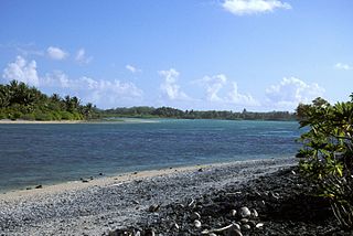
Nikumaroro, previously known as Kemins Island or Gardner Island, is a part of the Phoenix Islands, Kiribati, in the western Pacific Ocean. It is a remote, elongated, triangular coral atoll with profuse vegetation and a large central marine lagoon. Nikumaroro is about 7.5 km (4.7 mi) long by 2.5 km (1.6 mi) wide. The rim has two narrow entrances, both of which are blocked by a wide reef, which is dry at low tide. The ocean beyond the reef is very deep, and the only anchorage is at the island's west end, across the reef from the ruins of a mid-20th-century British colonial village, but this is safe only with the southeast trade winds. Landing has always been difficult and is most often done south of the anchorage. Although occupied at various times during the past, the island is uninhabited today.
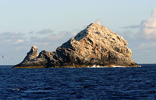
The Gardner Pinnacles are two barren rock outcrops surrounded by a reef and located in the Northwestern Hawaiian Islands.
The Phoenix Islands, or Rawaki, are a group of eight atolls and two submerged coral reefs that lie east of the Gilbert Islands and west of the Line Islands in the central Pacific Ocean, north of Samoa. They are part of the Republic of Kiribati. Their combined land area is 28 square kilometres (11 sq mi). The only island of any commercial importance is Canton Island. The other islands are Enderbury, Rawaki, Manra, Birnie, McKean, Nikumaroro, and Orona.

Starbuck Island is an uninhabited coral island in the central Pacific, and is part of the Central Line Islands of Kiribati. Its former names include "Barren Island", "Coral Queen Island", "Hero Island", "Low Island", and "Starve Island".

Essex was an American whaling ship from Nantucket, Massachusetts, which was launched in 1799. On November 20, 1820, while at sea in the southern Pacific Ocean under the command of Captain George Pollard Jr., the ship was attacked and sunk by a sperm whale. About 2,000 nautical miles (3,700 km) from the coast of South America, the 20-man crew was forced to make for land in three whaleboats with what food and water they could salvage from the wreck.

Owen Chase was first mate of the whaler Essex, which sank in the Pacific Ocean on November 20, 1820, after being rammed by a sperm whale. Soon after his return to Nantucket, Chase wrote an account of the shipwreck and the attempts of the crew to reach land in small boats. The book, Narrative of the Most Extraordinary and Distressing Shipwreck of the Whale-Ship Essex, was published in 1821 and would inspire Herman Melville to write Moby-Dick.
Schjetman Reef is a supposed phantom island in the North Pacific west of Hawaii, reported discovered by the Norwegian captain Ole Andreas Schjetnan in 1868. He reported its coordinates to be 16°8′N178°58′W. The island was reported to be 1.5 nautical miles (2.8 km) long (north-to-south) and 0.5 nautical miles (0.9 km) wide (east-to-west). Due to a similar latitude to Johnston Atoll, it is possible that it was simply a misreading of longitude. Regardless, there is no evidence of any islands in the remote vicinity of Schjetnan's reported location, with the closest prominence of any size being a small, unnamed seamount roughly 100 miles to the east.
Winslow Reef is an underwater feature of the Phoenix Islands, Republic of Kiribati, located 200 kilometres (120 mi) north-northwest of McKean Island at 01°36′S174°57′W. It is the northernmost and westernmost feature of the Phoenix Islands, not counting the outlying Baker and Howland Islands. It has a least depth of 11 m (36 ft). The reef is about 1.6 km (1 mi) long east–west, and about half that wide. The bottom is pink coral and red sand.
Carondelet Reef is a horseshoe-shaped reef, presumably a submerged atoll formation, of the Phoenix Islands, also known as the Rawaki Islands, in the Republic of Kiribati. It is located 106 kilometres southeast of Nikumaroro, at 05°34′S173°51′W, and has a least depth of 1.8 metres (5.9 ft). It is reported to be approximately 1.5 kilometres (0.9 mi) in length. The sea occasionally breaks over it.

McKean Island is a small, uninhabited island in the Phoenix Islands, Republic of Kiribati. Its area is 57 hectares.

Some members of the colonial Coffin family were whalers, agents, merchants, and traders who were prominent during the triangular trade in the United States and Canada. Coffin ship owners, captains, masters, and crew men operated triangle and bilateral trade ships out of Nantucket, Massachusetts, US eastern seaports, and Canadian seaports from the 17th to 19th centuries.
The Starbuck family were prominent in the history of whaling in the Hawaiian Islands, based in Nantucket, Massachusetts, from the seventeenth to the nineteenth centuries. Some members of the family gained wider exposure due to their discovery of various islands in the Pacific Ocean.
Ganges, was a whaleship from Nantucket, Massachusetts, launched in 1809 in Massachusetts, that operated in the Pacific Ocean from 1815 to 1853. It was probably the vessel reported to have found Gardner Island in the Phoenix group. Although Barzillai Folger, the master of the ship during its voyage of 1835–39, is sometimes credited with being the first to discover the right whales of the Northwest coast, the Frenchman Narcisse Chaudiere, in Gange, preceded Folger. Chaudiere cruised on this ground during the summer of 1835, while Folger didn't leave port until October 26 of the same year.

Commercial whaling in the United States dates to the 17th century in New England. The industry peaked in 1846–1852, and New Bedford, Massachusetts, sent out its last whaler, the John R. Mantra, in 1927. The whaling industry was engaged with the production of three different raw materials: whale oil, spermaceti oil, and whalebone. Whale oil was the result of "trying-out" whale blubber by heating in water. It was a primary lubricant for machinery, whose expansion through the Industrial Revolution depended upon before the development of petroleum-based lubricants in the second half of the 19th century. Once the prized blubber and spermaceti had been extracted from the whale, the remaining majority of the carcass was discarded.
Nantucket shipbuilding began in the late 1700s and culminated in the construction of notable whaling ships during the early 19th century. Shipbuilding was predominantly sited at Brant Point. Whaling ship construction concluded in 1838.
Ganges Island, a phantom island known as Nakanotorishima in Japanese, appeared at 30°45′N154°25′E on maps of the late 19th and early 20th centuries. Reports of its disappearance appeared in 1933.
The whaler Globe, of Nantucket, Massachusetts, was launched in 1815. She made three whaling voyages and then in 1824, on her fourth, her crew mutinied, killing their officers. Eventually most of the mutineers were killed or captured and the vessel herself was back in Nantucket in her owners' hands. She continued to whale until about 1828. She was broken up circa 1830.

Two Brothers was a Nantucket whaleship that sank on the night of February 11, 1823, off the French Frigate Shoals. The ship's captain was George Pollard, Jr., former captain of the famous whaleship Essex. The wreck was discovered in 2008 by a team of marine archaeologists working on an expedition for the National Oceanic and Atmospheric Administration in the Papahānaumokuākea Marine National Monument. She is thought to have been built in 1804 by Joseph Glidden in Hallowell, Maine.

The Sivuch'i Rocks are a group of barren islets and rocks on the eastern side of Uda Bay, in the western Sea of Okhotsk.
The Bussol Strait, known in Japan as the North Urup Channel, is a wide strait that separates the islands of Broutona and Chirpoy to the west from Simushir to the east. It is nearly 58 km wide, making it the largest channel in the Kuril Islands.
References
- Dunmore, John (1992); Who's Who in Pacific Navigation, Australia:Melbourne University Press, ISBN 0-522-84488-X
- Sharp, Andrew (1960); The Discovery of the Pacific Islands, Oxford:Oxford University Press,
- Starbuck, Alexander (1878). History of the American Whale Fishery from Its Earliest Inception to the year 1876. Castle. ISBN 1-55521-537-8.
- Quanchi, Max & Robson, John, (2005); Historical Dictionary of the Discovery and Exploration of the Pacific Islands, USA: Scarecrow Press, ISBN 0-8108-5395-7