Related Research Articles

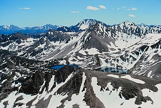
The White Cloud Mountains are part of the Rocky Mountains of the western United States, located in central Idaho, southeast of Stanley in Custer County. The range is located within the Sawtooth National Recreation Area (SNRA) and partially within the Cecil D. Andrus–White Clouds Wilderness.

Castle Peak is a mountain in the western United States, the highest peak in the White Cloud Mountains of central Idaho and the Idaho Batholith. Located in Custer County, it is the 25th highest peak in the state, and the ninth most prominent.
Cirque Lake is an alpine lake in Custer County, Idaho, United States, located in the White Cloud Mountains in the Sawtooth National Recreation Area. The lake is accessed from Sawtooth National Forest trail 601.
Rough Lake is an alpine lake in Custer County, Idaho, United States, located in the White Cloud Mountains in the Sawtooth National Recreation Area. The lake is accessed from Sawtooth National Forest trails 647 and 616.
Sheep Lake is an alpine lake in Custer County, Idaho, United States, located in the White Cloud Mountains in the Sawtooth National Recreation Area. The lake can be accessed from Sawtooth National Forest trail 601.
Slide Lake is an alpine lake in Custer County, Idaho, United States, located in the White Cloud Mountains in the Sawtooth National Recreation Area. The lake can be accessed from Sawtooth National Forest trail 601.
Snow Lake is an alpine lake in Custer County, Idaho, United States, located in the White Cloud Mountains in the Sawtooth National Recreation Area. The lake can be accessed via Sawtooth National Forest trail 601.
Sapphire Lake is an alpine lake in Custer County, Idaho, United States, located in the White Cloud Mountains in the Sawtooth National Recreation Area. No trails lead to the lake, but it can be most easily accessed from Sawtooth National Forest trail 601.

Shelf Lake is an alpine lake in Custer County, Idaho, United States, located in the White Cloud Mountains in the Sawtooth National Recreation Area. The lake is named for a distinct rock shelf extending around the south and west shores of the lake.

Hummock Lake is an alpine lake in Custer County, Idaho, United States, located in the White Cloud Mountains in the Sawtooth National Recreation Area. The lake is accessed from Sawtooth National Forest trail 683.

Headwall Lake is an alpine lake in Custer County, Idaho, United States, located in the White Cloud Mountains in the Sawtooth National Recreation Area. The lake is accessed from Sawtooth National Forest trail 683.
Lonesome Lake is an alpine lake in Custer County, Idaho, United States, located in the White Cloud Mountains in the Sawtooth National Recreation Area. The lake is accessed from Sawtooth National Forest trail 683.
Noisy Lake is an alpine lake in Custer County, Idaho, United States, located in the White Cloud Mountains in the Sawtooth National Recreation Area. While no trails lead to the lake, it can be accessed from Sawtooth National Forest trail 047.
Glacier Lake is an alpine lake in Custer County, Idaho, United States, located in the White Cloud Mountains in the Sawtooth National Recreation Area. While no trails lead to the lake, it can be accessed from Sawtooth National Forest trail 047.
The Kettles are a chain of four small alpine glacial lakes in Custer County, Idaho, United States, located in the White Cloud Mountains in the Sawtooth National Recreation Area. The lakes are located in the upper portion of the Big Boulder Creek watershed east of D. O. Lee Peak in the uppermost portion of the Big Boulder Lakes Basin. Sawtooth National Forest trail 601 along leads to the Big Boulder Lakes.
The Boulder Chain Lakes are a chain of thirteen alpine and glacial Paternoster lakes in Custer County, Idaho, United States, located in the White Cloud Mountains in the Sawtooth National Recreation Area. The lakes are located in the upper portion of the Little Boulder Creek watershed north of Merriam Peak. Sawtooth National Forest trail 683 along leads to the Boulder Chain Lakes.

Chamberlain Basin is a drainage basin that contains a chain of ten alpine and glacial Paternoster lakes in Custer County, Idaho, United States, located in the White Cloud Mountains in the Sawtooth National Recreation Area. Lakes are located on the upper portion of Chamberlain Creek in the Germania Creek watershed, a tributary of the East Fork Salmon River. Castle Peak, the highest summit in the White Cloud Mountains, rises to the east and north of Chamberlain Basin. Sawtooth National Forest trail 047 crosses the basin, although most people begin their trips at the Fourth of July Creek trailhead. Individual lakes do not have official names and are listed from lowest to highest elevation.
The Casino Lakes are a chain of four alpine glacial lakes in Custer County, Idaho, United States, located in the White Cloud Mountains in the Sawtooth National Recreation Area. The lakes are located on the upper portion of the Big Casino Creek watershed, a tributary of the Salmon River. The lakes have not been individually named, and Sawtooth National Forest trail 646 leads to the lakes.

Merriam Peak, at 10,920 feet (3,330 m) is one of the peaks of the White Cloud Mountains of Custer County, Idaho. It was named for John H. Merriam who played an instrumental role in protecting the area from being mined for molybdenum. Merriam Peak is located in the middle of the range just north of Castle Peak, the highest point in the range. The peak is located in the White Clouds roadless area of Sawtooth National Recreation Area.
References
- ↑ Sawtooth National Forest. "Sawtooth National Forest" [map].1:126,720, 1"=2 miles. Twin Falls, Idaho: Sawtooth National Forest, United States Forest Service, 1998.