The Snowdon Mountain Railway is a narrow gauge rack and pinion mountain railway in Gwynedd, north-west Wales. It is a tourist railway that travels for 4.7 miles (7.6 km) from Llanberis to the summit of Snowdon, the highest peak in Wales.

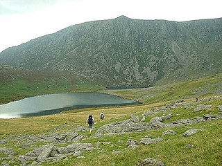
Garnedd Ugain, often referred to as "Crib-y-Ddysgl", is a mountain in Wales that forms part of the Snowdon Massif. It is the second highest peak in Wales, and lies just under one kilometre north of the summit of Snowdon itself.
Bleaklow is a high, largely peat-covered, gritstone moorland, just north of Kinder Scout, across the Snake Pass (A57), in the Derbyshire High Peak near the town of Glossop. Much of it is nearly 2,000 feet (610 m) above sea level and the shallow bowl of Swains Greave on its eastern side is the source of the River Derwent.

Carnedd Llewelyn, usually spelt Carnedd Llywelyn in Welsh, is a mountain massif in the Carneddau range in Snowdonia, north-west Wales. It is the highest point of the Carneddau and the second highest peak by relative height in Wales, 49th in the British Isles and lies on the border between Gwynedd and Conwy.

Elidir Fawr is a mountain in Snowdonia, north Wales, the northernmost peak in the Glyderau.

Glyder Fach is a mountain in Snowdonia, north-west Wales, and is the second highest of the Glyderau and the sixth highest in Wales. Routes to the summit lead from Tryfan and Bristly Ridge to the north, via Glyder Fawr from Pen-y-Pass to the south, and along the Glyder ridge to the east, towards Capel Curig. It is a popular spot for climbers.

Moel Hebog is a mountain in Snowdonia, north Wales which dominates the view west from the village of Beddgelert. It gives name to a whole range of peaks in the north-western corner of Snowdonia, which include the Nantlle Ridge and Mynydd Mawr.
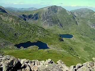
Y Garn is a mountain in Snowdonia, North Wales, part of the Glyderau.

The Clwydian Range is a series of hills and mountains in north east Wales that runs from Llandegla in the south to Prestatyn in the north, with the highest point being the popular Moel Famau. The range is designated as an Area of Outstanding Natural Beauty. The AONB has been extended to include the Dee Valley around Llangollen including Moel y Gamelin, the Horseshoe Pass and Castell Dinas Bran, increasing the area to 150 square miles. The highest point in the AONB is Moel y Gamelin at 1,893 feet.

Ysgafell Wen is a subsidiary summit of Allt-fawr in Snowdonia, North Wales. It is the highest point on a broad ridge that stretches to the north-west of Moel Druman, and includes one other summit, Ysgafell Wen North Top.

Tal y Fan is an outlying peak of the Carneddau mountains in North Wales. It is one of the four Marilyns that make up the Carneddau, the others being Carnedd Llywelyn, Pen Llithrig y Wrach and Creigiau Gleision.
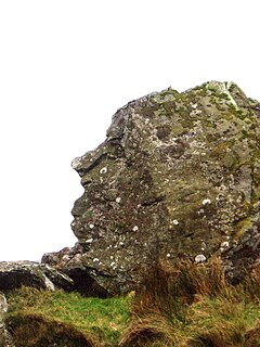
Pitt’s Head is a distinctive rock located at grid reference SH576515, close to the A4085 road in Gwynedd, Wales. Its distinction lies in a resemblance to the profile of politician William Pitt the Younger.
Y Garn is a top of Mynydd Drws-y-Coed in Snowdonia, north Wales and is the easterly end of the Nantlle Ridge.

Denbigh Moors is an upland region in Conwy and Denbighshire in north-east Wales, between Snowdonia and the Clwydian Range. It includes the large reservoirs Llyn Brenig and Llyn Alwen, and the Clocaenog Forest, which has one of Wales's last populations of red squirrels. Its highest point is Mwdwl-eithin, at 532 metres (1,745 ft) above sea level, making it higher than Exmoor. Another summit is Moel Seisiog, at 468 metres (1,535 ft), which is also the source of the River Elwy. On its western edge, overlooking the Conwy Valley, lies the Moel Maelogan wind farm. Three other summits reach over 500 metres – Craig Bron-banog, Gorsedd Bran, and Foel Goch. The ruined hunting lodge of Gwylfa Hiraethog lies on the moors, and nearby is one of the highest inns in Britain, the Sportsmans Arms. As well as the large reservoirs of Llyn Brenig and Alwen Reservoir there are two sizeable natural lakes – Llyn Alwen and Llyn Aled, and two small ones, Llyn Bran and Llyn y Foel-frech – as well as another reservoir, Aled Isaf Reservoir.
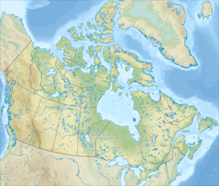
The Devon Ice Cap is an ice cap on eastern Devon Island, Nunavut, Canada, covering an area of over 12,000 km2 (4,600 sq mi). The highest point on Devon Island is found at the summit of the ice cap, with an elevation of 1,921 m (6,302 ft). The ice cap has a maximum thickness of 880 m (2,887 ft), and has been steadily shrinking since 1985.

Mica Peak is the name of two separate mountain summits in the United States located approximately 5.49 miles (9 km) apart; one in Spokane County, Washington and the other in Kootenai County, Idaho. The two peaks are located along the same ridge, which separates the Spokane Valley and Rathdrum Prairie from the Palouse. The mountains have an elevation difference of only 31 ft (9.4 m) and are the southernmost peaks of the Selkirk Mountains.

Moel y Parc is a hill on the border between Denbighshire and Flintshire in Wales. It is one of the Clwydian Hills, rising 398 metres (1,306 ft) above sea level and is located at OS grid reference SJ114703. There is a television mast near the summit. The summit marks the boundary of Aberwheeler and Ysceifiog communities, and is the site of a cairn and tumulus.

Mynydd Drws-y-Coed is a peak on the Nantlle Ridge in Snowdonia, north Wales. It is located at the easterly end of the ridge, and is a subsidiary summit of Trum y Ddysgl. It has steep south facing cliffs, the summit area being the highest point on a thin ridge.
Mynydd y Garn is a hill in the northwest of the Isle of Anglesey in north Wales. Its 170m high summit is crowned by a trig point and a stone obelisk. Erected in 1897 it commemorates Sir William Thomas, ship-owner and one time High Sheriff of Anglesey.