Garratt Lane

Last updated

Garratt Lane in 2008 Garratt Lane, London SW18 - geograph.org.uk - 725692.jpg
Garratt Lane in 2008

Garratt Lane is a long street (numbered to 1085) in the London Borough of Wandsworth, part of the A217 road. It connects Wandsworth High Street to Tooting Broadway and is approximately 4 kilometres (2.5 miles) long, arguably making it the longest street in the UK (0.5 miles longer than King Street in Aberdeen). It passes through the Earlsfield and Summerstown neighbourhoods which were fields of Wandsworth before their development in the late 19th century.

Contents

Description

Land use along Garratt Lane is a mix of commercial and residential. In the north, Southside Wandsworth is a suburban shopping centre situated amongst other retail and local services. Heading south, the stretch between Allfarthing Lane and Burntwood Lane is mainly diverse shophouses, including a few professional services, and the southern portion is mainly residential, although around Summerstown there are a few light industries, access to Wimbledon Stadium (now Plough Lane, home of AFC Wimbledon) and Streatham Cemetery.

The southernmost part of Garratt Lane is unusual in that two parallel streets exchanged names. The original Garratt Lane was a narrower street than Garratt Terrace, which was the main connection to Tooting Broadway. Many people mistakenly called it Garratt Lane, so it was agreed to exchange the names.

The south-east end of Garratt Lane, running from the junction with Fountain Road and Upper Tooting Road, was previously called Defoe Road.

Garrat Elections

The Leather Bottle, Earlsfield Leather Bottle, Earlsfield - panoramio.jpg
The Leather Bottle, Earlsfield

Most large public houses have survived along Garratt Lane, including The Old Sergeant and the Leather Bottle , both of which date to the 18th century. The latter figured in the mock Garrat Elections of the late 18th century, which were featured in the play The Mayor of Garratt by Samuel Foote. [1]

Transportation

Garratt Lane is one of three major north–south routes in south-west Inner London, i.e. between the Lambeth/Southwark south bank areas and the gradual widening and receiving of local roads to the arterial A3, west of Wandsworth. The Lane follows a bank of the River Wandle so has quite a consistent rise as with the parallel A218 on the higher, western bank. Industries grew up in the 18th and 19th centuries along this east bank, which led to its prominence. A 1741 map of Rocque shows a road with a near identical orientation, which strongly implies the road had early origins. A 1786 map [2] shows and names Garratt Lane running approximately on its present route. This map also shows two lanes that intersect named: Half Farthing (now Allfarthing) and Burnt Wood (now Burntwood). The sub-settlement on its length was Garratt Green, Wandsworth.

In 1803 the first commercial railway in Britain was opened along much of the northern section. This was the Surrey Iron Railway which connected the Thames at Wandsworth with these industries, and those in Merton and Croydon. No sign remains of the railway which was horse-drawn.

Public transport in the form of horse buses was placed on the street in the latter part of the 19th century, and in 1903 the London County Council (LCC) extended and electrified the tramways. The trams started at the Thames near Westminster and went west and southwest on three route, one through Clapham Junction to Wandsworth, another through Brixton to Streatham, and one through Balham to Wimbledon. The routes through Garratt Lane connected all three with the focal point being Tooting.

When the London Passenger Transport Board was formed in 1933 to control all of London's transport, route 12 (from Tooting to London Bridge via Wandsworth & Battersea) and route 30 (from Tooting to Shepherd's Bush via Putney) ran the length of Garratt Lane. These routes were transformed to trolleybus (612 and 630) routes in 1937 with conversion to bus service in the 1960s (No 44 & 220 (later replaced by the 270) respectively) as London's tram services were discontinued. Garratt Lane is served along its length by TfL bus routes 44, 77, and 270. Routes G1, 155, 264, 280 and 493 serve the southern end, with the G1 continuing to Battersea via St George's Hospital and Burntwood Lane, and the remainder terminating at St George's Hospital. Routes 28 and 220 terminate at Southside Wandsworth at the northern end of Garratt Lane.

The South West Main Line serves Garratt Lane at Earlsfield and the nearest London Underground station is Tooting Broadway, just opposite the south end of Garratt Lane at the junction of the A24 and A217.

Buildings listed by the Borough

There are four listed properties on Garratt Lane:

Local history plaques

Related Research Articles

<span class="mw-page-title-main">Tooting</span> Human settlement in England

Tooting is a district in South London, forming part of the London Borough of Wandsworth. It is located 5 miles south south-west of Charing Cross.

<span class="mw-page-title-main">London Borough of Wandsworth</span> London borough in United Kingdom

Wandsworth is a London borough in south London; it forms part of Inner London and has an estimated population of 329,677 inhabitants. Its main named areas are Battersea, Balham, Putney, Tooting and Wandsworth Town.

<span class="mw-page-title-main">A24 road (England)</span> Major road in southern England

The A24 is a major road in England that runs for 53.2 miles (85.6 km) from Clapham in south-west London to Worthing on the English Channel in West Sussex via the suburbs of south-west London, as well as through the counties of Surrey and West Sussex.

<span class="mw-page-title-main">Earlsfield</span> Human settlement in England

Earlsfield is an area within the London Borough of Wandsworth, London, England. It is a typical south London suburb and comprises mostly residential Victorian terraced houses with a high street of shops, bars, and restaurants between Garratt Lane, Allfarthing Lane, and Burntwood Lane. The population of Earlsfield at the 2001 Census was 12,903, increasing to 15,448 at the 2011 Census.

<span class="mw-page-title-main">Anglican Diocese of Southwark</span> Diocese of the Church of England

The Diocese of Southwark is one of the 42 dioceses of the Church of England, part of the worldwide Anglican Communion. The diocese forms part of the Province of Canterbury in England. It was created on 1 May 1905 from part of the ancient Diocese of Rochester that was served by a suffragan bishop of Southwark (1891–1905). Before 1877 most of the area was part of the Diocese of Winchester, some being part of the Diocese of London.

<span class="mw-page-title-main">Tooting Broadway tube station</span> London Underground station

Tooting Broadway is a London Underground station in Tooting in the London Borough of Wandsworth, South London. The station is on the Northern line, between Tooting Bec and Colliers Wood stations and is in Travelcard Zone 3.

<span class="mw-page-title-main">Earlsfield railway station</span> National Rail station in London, England

Earlsfield railway station is on the South West Main Line serving Earlsfield in the London Borough of Wandsworth, South London. The station is in Travelcard Zone 3, 5 miles 46 chains (9.0 km) from London Waterloo and situated between Clapham Junction and Wimbledon. It is operated by South Western Railway, as are all the trains serving it.

<span class="mw-page-title-main">Tooting Bec</span> Human settlement in England

Tooting Bec is in the London Borough of Wandsworth, south London, England.

<span class="mw-page-title-main">Tooting (UK Parliament constituency)</span> Parliamentary constituency in the United Kingdom, 1974 onwards

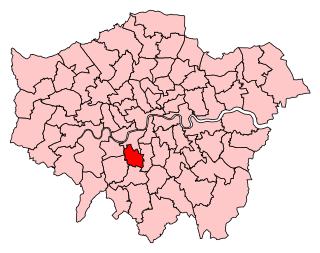
Tooting is a constituency created in 1974 in Greater London. It is represented in the House of Commons of the UK Parliament since 2016 by Dr. Rosena Allin-Khan, a member of the Labour Party.

<span class="mw-page-title-main">A217 road</span> Road in England

The A217 is a road in London and Surrey in England. It runs north–south. It runs from Kings Road in Fulham, London, crosses the Thames at Wandsworth Bridge, then passes through Wandsworth, Earlsfield, Summerstown, Tooting, Mitcham, Rosehill and Sutton Common in Sutton, then Cheam. Then, widened as a dual carriageway, comes Belmont, a suburban district built on a slope rising southward. On the North Downs in Surrey the road then skirts past Banstead and through its late 19th century offspring villages particularly Burgh Heath and Kingswood, Surrey. It then crosses the M25 motorway at Junction 8, then, returning to single carriageways, passes through the castle town of Reigate. It then cuts through the green buffer farmland of two rural villages and terminates at the road network at Gatwick Airport's northern perimeter.

<span class="mw-page-title-main">Parks and open spaces in the London Borough of Wandsworth</span>

The inner London borough of Wandsworth contains some 670 hectares of green space in the form of parks, commons, allotments and cemeteries, which is the largest amount for an Inner London borough. Central London borders some of the borough's boundary with the Thames the closest park to which is Battersea Park.

Wandsworth Central was a parliamentary constituency in the Wandsworth district of South London. It returned one Member of Parliament (MP) to the House of Commons of the Parliament of the United Kingdom, elected by the first-past-the-post voting system.

Wandsworth was the name of a borough constituency created in 1885, abolished in 1918, covering the vast bulk of today's London Borough of Wandsworth in South London but excluding Battersea. It returned one Member of Parliament (MP) to the House of Commons of the UK Parliament.

Summerstown is a district of south-west London located on the boundary between the London Borough of Wandsworth and the London Borough of Merton. It is an area on the north eastern edge of Wimbledon, south of Earlsfield, west of Tooting and north of Collier's Wood. The district is bisected by the A217 and bordered by the River Wandle.

<span class="mw-page-title-main">Night buses in London</span> Series of night bus routes that serve Greater London

The London Night Bus network is a series of night bus routes that serve Greater London. Services broadly operate between the hours of 23:00 and 06:00.

Fairfield is one of the most central wards in the London Borough of Wandsworth, London. Fairfield contains mostly Wandsworth Town and a large neighbourhood in Battersea. Fairfield contains Wandsworth High Street, Old York Road and the council buildings themselves. The ward forms a cross shape, running from Mexfield Road on the edge of Putney in the west, to Plough Road near Clapham Junction in the east, and from the River Thames to the west of Wandsworth Bridge in the north, to Allfarthing Lane to the east of Garratt Lane in the south.

<span class="mw-page-title-main">Wandsworth District (Metropolis)</span>

Wandsworth was a local government district within the metropolitan area of London, England from 1855 to 1900. It was formed by the Metropolis Management Act 1855 and was governed by the Wandsworth District Board of Works, which consisted of elected vestrymen.

<span class="mw-page-title-main">Temperance Billiard Halls</span>

Temperance Billiard Hall Co. Ltd. was a company founded in 1906 in Pendleton, Lancashire, as part of the wider temperance movement, which built billiard halls in the north of England and London.

<span class="mw-page-title-main">Leather Bottle, Earlsfield</span> Pub in Earlsfield, London

The Leather Bottle is a pub at 538 Garratt Lane, Earlsfield, London SW17.

References

  1. The Mayor of Garratt Google books. Retrieved 2014-11-12
  2. Carey's map of The Environs of London sheet 34
  3. "Plaque to be unveiled for Summerstown singer Marc Bolan". Wandsworth Guardian. August 2021.

51°26′21″N0°11′12″W / 51.4392°N 0.1868°W / 51.4392; -0.1868