
The Prince Edward Viaduct System, commonly referred to as the Bloor Viaduct, is the name of a truss arch bridge system in Toronto, Ontario, Canada, connecting Bloor Street East, on the west side of the system, with Danforth Avenue on the east. The system includes the Rosedale Valley phase and the Sherbourne Phase, an embankment built to extend Bloor Street East to the Rosedale Ravine from Sherbourne Street. The Don Valley phase of the system, the most recognizable, spans the Don River Valley, crossing over the Bayview Avenue Extension, the Don River, and the Don Valley Parkway.
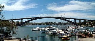
Gladesville Bridge is a heritage-listed concrete arch road bridge that carries Victoria Road over the Parramatta River, linking the Sydney suburbs of Huntleys Point and Drummoyne, in the local government areas of Canada Bay and Hunter's Hill, in New South Wales, Australia. Despite its name, the bridge is not located in Gladesville.
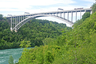
The Lewiston–Queenston Bridge, also known as the Queenston–Lewiston Bridge, is an arch bridge that crosses the Niagara River gorge just south of the Niagara Escarpment. The bridge was officially opened on November 1, 1962. It is an international bridge between the United States and Canada. It connects Interstate 190 in the town of Lewiston, New York to Highway 405 in the community of Queenston, Ontario. The Lewiston–Queenston Bridge is a twin of the Rainbow Bridge at Niagara Falls and designed by Richard Lee.
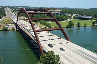
The Percy V. Pennybacker Jr. Bridge in Austin, Texas, is a through-arch bridge across Lake Austin which connects the northern and southern sections of the Loop 360 highway, also known as the "Capital of Texas Highway." The road is widely considered one of the most scenic urban drives in Texas, in large part due to this arched weathering-steel bridge and the rolling hills that flank the road. In 2001, 48,000 vehicles crossed the bridge daily. Ten years prior to this, 22,000 vehicles had crossed the bridge daily.
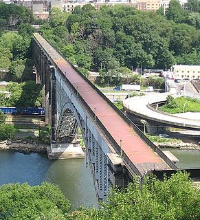
The High Bridge is the oldest bridge in New York City, having originally opened as part of the Croton Aqueduct in 1848 and reopened as a pedestrian walkway in 2015 after being closed for over 45 years. A steel arch bridge with a height of 140 ft (43 m) over the Harlem River, it connects the New York City boroughs of the Bronx and Manhattan. The eastern end is located in the Highbridge section of the Bronx near the western end of West 170th Street, and the western end is located in Highbridge Park in Manhattan, roughly parallel to the end of West 174th Street.

The Mike O'Callaghan–Pat Tillman Memorial Bridge is an arch bridge in the United States that spans the Colorado River between the states of Arizona and Nevada. The bridge is located within the Lake Mead National Recreation Area approximately 30 miles (48 km) southeast of Las Vegas, and carries Interstate 11 and U.S. Route 93 over the Colorado River. Opened in 2010, it was the key component of the Hoover Dam Bypass project, which rerouted US 93 from its previous routing along the top of Hoover Dam and removed several hairpin turns and blind curves from the route. It is jointly named for Mike O'Callaghan, Governor of Nevada from 1971 to 1979, and Pat Tillman, an American football player who left his career with the Arizona Cardinals to enlist in the United States Army and was killed in Afghanistan in 2004 by friendly fire.

The Humber Bay Arch Bridge is a pedestrian and bicycle through arch bridge south of Lake Shore Boulevard West in Toronto, Ontario, Canada. Completed in the mid-1990s, the bridge is part of the Martin Goodman Trail and is 139 metres (456 ft) in length, with a clear span of 100 metres (330 ft) over the mouth of the Humber River to protect the environmental integrity of the waterway.

The Washington Bridge is a 2,375-foot (724 m)-long arch bridge over the Harlem River in New York City between the boroughs of Manhattan and the Bronx. The crossing, opened in 1888, connects 181st Street and Amsterdam Avenue in Washington Heights, Manhattan, with University Avenue in Morris Heights, Bronx. It carries six lanes of traffic, as well as sidewalks on both sides. Ramps at either end of the bridge connect to the Trans-Manhattan Expressway and the Cross-Bronx Expressway.

The Seal Island Bridge is a bridge located in Victoria County, Nova Scotia. It is the third longest bridge span in the province.

The Helix Bridge, officially The Helix, and previously known as the Double Helix Bridge, is a pedestrian bridge linking Marina Centre with Marina South in the Marina Bay area in Singapore. It was officially opened on 24 April 2010 at 9 pm; however, only half was opened due to ongoing construction at the Marina Bay Sands. It is located beside the Benjamin Sheares Bridge and is accompanied by a vehicular bridge, known as the Bayfront Bridge. The entire bridge was opened on 18 July 2010 to complete the entire walkway around Marina Bay.
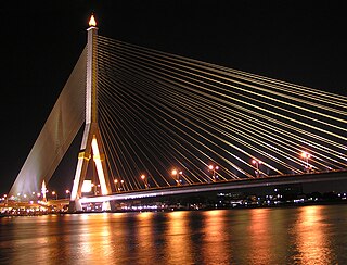
The Rama VIII Bridge is a cable-stayed bridge crossing the Chao Phraya River in Bangkok, Thailand. It was built to alleviate traffic congestion on the nearby Phra Pinklao Bridge. Construction of the bridge took place from 1999 to 2002. The bridge was opened on 7 May 2002 and inaugurated on 20 September, the birth anniversary of the late King Ananda Mahidol, after whom it is named. The bridge has an asymmetrical design, with a single pylon in an inverted Y shape on the west bank of the river. Its eighty-four cables are arranged in pairs on the side of the main span and in a single row on the other. The bridge has a main span of 300 metres (980 ft), and was one of the world's largest asymmetrical cable-stayed bridges at the time of its completion.

The Lamar Boulevard Bridge is a historic arch bridge carrying Texas State Highway Loop 343 over Lady Bird Lake in downtown Austin, Texas, United States. The bridge features six open-spandrel concrete arches spanning 659 feet (201 m) and carries tens of thousands of vehicles daily across the lake. Completed in 1942, the Lamar Boulevard Bridge was the second permanent bridge to cross the Colorado River, and one of the last Art Deco-style open-spandrel concrete arch bridges built in Texas. The bridge was named an Austin Landmark in 1993 and added to the National Register of Historic Places in 1994.

The Denver Millennium Bridge is the world's first cable-stayed bridge using post-tensioned structural construction. Its 200-foot (61m) white tapered steel mast rises above Denver's northwestern skyline, connected to the bridge deck and foundation anchors by steel cables. This unique footbridge crosses railroad tracks and the regional light rail system, climbing no higher than 25 feet (8m) above street level, thereby minimizing the height pedestrians must climb. Located near LoDo ,in Riverfront Park, the Millennium Bridge connects the popular 16th Street Mall with the Commons Park in the Central Platte Valley District of the Union Station neighborhood. The bridge is the first of three pedestrian bridges between Downtown Denver and the Highland neighborhood.

The BP Pedestrian Bridge, or simply BP Bridge, is a girder footbridge in the Loop community area of Chicago, United States. It spans Columbus Drive to connect Maggie Daley Park with Millennium Park, both parts of the larger Grant Park. Designed by Pritzker Prize-winning architect Frank Gehry and structurally engineered by Skidmore, Owings and Merrill, it opened along with the rest of Millennium Park on July 16, 2004. Gehry had been courted by the city to design the bridge and the neighboring Jay Pritzker Pavilion, and eventually agreed to do so after the Pritzker family funded the Pavilion.

The Infinity Bridge is a public pedestrian and cycle footbridge across the River Tees in the borough of Stockton-on-Tees in northern England. The bridge is situated one kilometre downriver of Stockton town centre, between the Princess of Wales Bridge and the Tees Barrage. It connects the Teesdale Business Park and the University of Durham's Queen's Campus in Thornaby-on-Tees on the south bank of the Tees with the Tees Valley Regeneration's £320 million North Shore development on the north bank.

Te Rewa Rewa Bridge is a pedestrian and cycleway bridge across the Waiwhakaiho River at New Plymouth in New Zealand. Its spectacular shape and setting make it a popular landmark.

The Phyllis J. Tilley Memorial Bridge is a pedestrian bridge in Fort Worth, Texas.

The James D. Pfluger Pedestrian and Bicycle Bridge is a shared use bridge for pedestrians and cyclists spanning Lady Bird Lake in downtown Austin, Texas. Opened in 2001, the bridge connects the north and south sides of the Ann and Roy Butler Hike-and-Bike Trail and features an unusual "double curve" design. The bridge runs parallel to the Lamar Boulevard Bridge, which carries road traffic across the lake roughly 200 feet (61 m) to the west.

The Samuel De Champlain Bridge, colloquially known as the Champlain Bridge, is a cable-stayed bridge design by architect Poul Ove Jensen and built to replace the original Champlain Bridge over the Saint Lawrence River in Quebec between the Island of Montreal and the South Shore suburbs. The new span is located just north of the original Champlain Bridge, which is currently being demolished. The new bridge carries eight lanes of automobile traffic of the A-10, A-15, and A-20, with one lane in each direction dedicated for buses. It also includes a multi-use lane for cyclists and pedestrians. The central portion of the bridge deck, still under construction, will carry the South Shore branch of the forthcoming Réseau express métropolitain (REM) automated light rail system. At 60 metres (200 ft) wide, the new Champlain Bridge is the widest cable-stayed bridge in the world that uses two planes of cables.


