The Frederick G. Gardiner Expressway, commonly known as the Gardiner Expressway or simply the Gardiner, is a partially at grade and elevated municipal expressway in Toronto, Ontario, Canada. Running close to the shore of Lake Ontario, it extends from the foot of the Don Valley Parkway (DVP) in the east, just past the mouth of the Don River, to the junction of Highway 427 and the Queen Elizabeth Way (QEW) in the west, for a total length of 18.0 kilometres (11.2 mi). East of Dufferin Street to just east of the Don River, the roadway is elevated for a length of 6.8 kilometres (4.2 mi), unofficially making it the longest bridge in Ontario. It runs above Lake Shore Boulevard east of Spadina Avenue.

Harbourfront is a neighbourhood on the northern shore of Lake Ontario within the downtown core of the city of Toronto, Ontario, Canada. Part of the Toronto waterfront, Harbourfront extends from Bathurst Street in the west, along Queens Quay, with its ill-defined eastern boundary being either Yonge Street or York Street. Its northern boundary is the Gardiner Expressway. Much of the district was former water lots filled in during the early 1900s to create a larger harbour district. After shipping patterns changed and the use of the Toronto harbour declined, the area was converted from industrial uses to a mixed-use district that is mostly residential and leisure.

Exhibition Place is a publicly owned mixed-use district in Toronto, Ontario, Canada, located by the shoreline of Lake Ontario, just west of downtown. The 197-acre (80 ha) site includes exhibit, trade, and banquet centres, theatre and music buildings, monuments, parkland, sports facilities, and a number of civic, provincial, and national historic sites. The district's facilities are used year-round for exhibitions, trade shows, public and private functions, and sporting events.

The Toronto waterfront is the lakeshore of Lake Ontario in the city of Toronto, Ontario, Canada. It spans 46 kilometres between the mouth of Etobicoke Creek in the west and the Rouge River in the east.

Bathurst Street is a main north–south thoroughfare in Toronto, Ontario, Canada. It begins at an intersection of the Queens Quay roadway, just north of the Lake Ontario shoreline. It continues north through Toronto to the Toronto boundary at Steeles Avenue. It is a four-lane thoroughfare throughout Toronto. The roadway continues north into York Region where it is known as York Regional Road 38.

Lake Shore Boulevard is a major arterial road running along more than half of the Lake Ontario waterfront in the city of Toronto, Ontario, Canada. Prior to 1998, two segments of Lake Shore Boulevard were designated as part of Highway 2, with the highway following the Gardiner Expressway between these two sections.

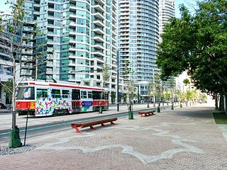
509 Harbourfront is a Toronto streetcar route in Ontario, Canada, operated by the Toronto Transit Commission and connecting Union Station with Exhibition Loop.
Queens Quay is a prominent street in the Harbourfront neighbourhood of Toronto, Ontario, Canada. The street was originally commercial in nature due to the many working piers along the waterfront; parts of it have been extensively rebuilt in since the 1970s with parks, condominiums, retail, as well as institutional and cultural development.
Bathurst Street Wharf was a series of shipyards located in Toronto, Ontario, Canada, between Bathurst Street and Spadina Avenue along Lake Shore Boulevard West.

The 511 Bathurst is a Toronto streetcar route operated by the Toronto Transit Commission in Ontario, Canada.

Niagara is a neighbourhood in Toronto, Ontario, Canada, located south of Queen Street West; it is usually bordered by Strachan Avenue to the west, Bathurst Street to the east, and the railway corridor to the south, and so named because Niagara Street runs through the centre of it. The eastern portion of this area was first planned as the New Town Extension when Toronto was incorporated as a city. The area was developed as a residential area for the workers of industries located along the CN and CP railway corridors. It remains a working-class neighbourhood that has seen the development of new condominium apartment buildings.
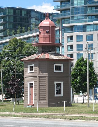
The Queen's Wharf Lighthouse is a lighthouse in Toronto, Ontario, Canada, situated at Fleet Street just east of the Princes' Gates at Exhibition Place. The octagonal building was originally one of a pair of lighthouses built in 1861 at Queen's Wharf, replacing an earlier 16-foot lighthouse built in 1838. The 11-metre (36-foot) three-storey wood structure is one of two surviving 19th-century lighthouses in Toronto.

Exhibition Loop is the terminus for the 509 Harbourfront and 511 Bathurst streetcar routes, the 174 Ontario Place-Exhibition, and the 307 Blue Night Bathurst bus routes. Exhibition Loop serves Exhibition Place, Coca-Cola Coliseum, BMO Field and connects with GO Transit at the Exhibition GO Station.

CityPlace is a neighbourhood in Downtown Toronto, Ontario, Canada, within the former Railway Lands. When completed, this area will be the largest residential development ever created in Toronto. The area is bordered by Bathurst Street to the west, Lake Shore Boulevard to the south, and Front Street to the north and Blue Jays Way and Rogers Centre to the east. Cityplace is also a 5- to 10-minute walk from King Street West and Liberty Village and a 10- to 20-minute walk from Toronto's financial district. The neighbourhood is also home to the Canoe Landing Park designed by famed Canadian writer and artist Douglas Coupland.
The Waterfront West LRT (WWLRT) is a proposed streetcar line in Toronto, Ontario, Canada. The WWLRT is currently part of a City project called the Waterfront Transit Reset which also includes the East Bayfront LRT. The WWLRT was initially proposed as part of the Transit City plan to expand transit services offered by the Toronto Transit Commission that was announced March 16, 2007. The new line was to use existing parts of the Toronto streetcar system, extending from Union station to Long Branch Loop via Exhibition Place.

Turning loops of the Toronto streetcar system serve as termini and turnback points for streetcar routes in Toronto, Ontario, Canada. The single-ended streetcars require track loops in order to reverse direction. Besides short off-street track loops these can also be larger interchange points, having shelters and driver facilities, or be part of a subway station structure for convenient passenger interchange.
East Bayfront, or the East Bayfront Precinct, is an emerging neighbourhood in Toronto, Ontario, Canada. It is currently undergoing a transformation from industrial use to mixed-use as part of Waterfront Toronto's plans to create a residential and commercial district urban core near the lake.

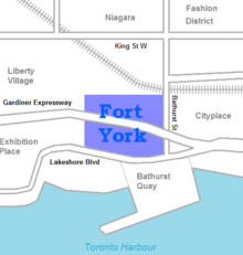
Fort York Armoury is a Canadian Forces facility located near the grounds of the Canadian National Exhibition in Toronto, Ontario, Canada. It is located at the intersection of Fleet Street and Fort York Boulevard, close to the historic Old Fort York in the neighbourhood of Fort York. It currently hosts several units of the Primary Reserve and the Canadian Cadet Organization.
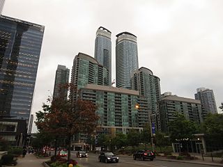
South Core is a neighbourhood located in downtown Toronto, Ontario, Canada. The South Core occupies the eastern portions of the Railway Lands. The remodeling and restoration of Union Station and the construction of a new wave of business and condominium towers is central to this area's forecast growth.
"Forecasters expect the downtown population to grow 80 per cent to 130,000 by 2031. With the financial district just to the north and the new high-rise South Core on the other side, Union is right at the centre."

The Bentway, formerly Project: Under Gardiner, is a public trail and corridor space underneath the Gardiner Expressway in Toronto, Ontario, Canada. It is repurposed land that was in sections vacant, rail lines, parking lots and outdoor storage.