Gattendorf

Last updated
Gattendorf
Schloss Gattendorf von Sueden.jpg
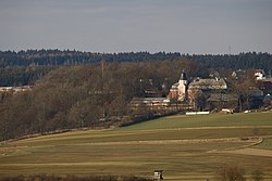
Gattendorf Castle seen from the south
Wappen von Gattendorf.svg
Coat of arms
Location of Gattendorf within Hof district
Gattendorf in HO.svg
Germany adm location map.svg
Red pog.svg
Gattendorf
Bavaria location map.svg
Red pog.svg
Gattendorf
Coordinates: 50°19′N12°1′E / 50.317°N 12.017°E / 50.317; 12.017 Coordinates: 50°19′N12°1′E / 50.317°N 12.017°E / 50.317; 12.017
Country Germany
State Bavaria
Admin. region Oberfranken
District Hof
Municipal assoc. Feilitzsch
Subdivisions15 Ortsteile
Government
   Mayor (202026) Stefan Müller [1] (CSU)
Area
  Total22.18 km2 (8.56 sq mi)
Elevation
544 m (1,785 ft)
Population
 (2020-12-31) [2]
  Total1,020
  Density46/km2 (120/sq mi)
Time zone UTC+01:00 (CET)
  Summer (DST) UTC+02:00 (CEST)
Postal codes
95185
Dialling codes 09281
Vehicle registration HO
Website www.gattendorf.de

Gattendorf is a municipality in Upper Franconia in the district of Hof in Bavaria in Germany.

The distinctive swan coat-of-arms of the municipality of Gattendorf was adopted as municipal coat-of-arms in 1974 after the extinction, in 1944, of the local noble family von Schmidt auf Altenstadt.

Related Research Articles

Weilheim-Schongau is a Landkreis (district) in the south of Bavaria, Germany. Neighboring districts are Landsberg, Starnberg, Bad Tölz-Wolfratshausen, Garmisch-Partenkirchen and Ostallgäu.

Gröbenzell Place in Bavaria, Germany

Gröbenzell is a municipality near Munich in the district Fürstenfeldbruck, in Bavaria, Germany. It was founded in 1952, and has a population of 19,202. Gröbenzell is often called a garden city, which is also illustrated by the two flowers in the coat of arms.

Eching, Freising Place in Bavaria, Germany

Eching is a municipality in the district of Freising, in Upper Bavaria, Germany.

Oberviechtach Place in Bavaria, Germany

Oberviechtach is a town in the district of Schwandorf, in Bavaria, Germany. It is situated 31 km (19 mi) southeast of Weiden in der Oberpfalz, and 27 km (17 mi) northeast of Schwandorf. It is famous for being the birthplace of Johann Andreas Eisenbarth. The name comes from pine (Fichte) which is also represented on the coat of arms of the town.

Parsberg Place in Bavaria, Germany

Parsberg is a town in the county of Neumarkt in Bavaria, Germany. It is 23 km southeast of Neumarkt in der Oberpfalz, and 33 km northwest of Regensburg, next to the A3 autobahn, the main route from Nuremberg to Regensburg. It was formerly the seat of the Counts of Parsberg, whose coat of arms is now used by the town.

Gebsattel Place in Bavaria, Germany

Gebsattel is a municipality in the district of Ansbach in Bavaria in Germany. It lies on the Tauber River.

Grub am Forst Place in Bavaria, Germany

Grub am Forst is a municipality in the district of Coburg in Bavaria in Germany. It has ca 3,100 residents. The nearest large town is Coburg. The following villages are part of it:

Weidhausen Place in Bavaria, Germany

Weidhausen bei Coburg is a municipality in the southeastern portion of the Coburg district of Bavaria in Germany.

Kleinsendelbach Place in Bavaria, Germany

Kleinsendelbach is a municipality in the district of Forchheim in Bavaria in Germany. It is located about 17 Kilometers south of the town of Forchheim and 15 Kilometers to the east of the city of Erlangen, and is part of the administration community Dormitz.

Pinzberg Place in Bavaria, Germany

Pinzberg is a municipality in the district of Forchheim in Bavaria in Germany.

Saal an der Donau Place in Bavaria, Germany

Saal is a municipality in the district of Kelheim in Bavaria in Germany. It is located along the banks of the Danube River, around 25 km southwest of Regensburg.

Guttenberg, Bavaria Place in Bavaria, Germany

Guttenberg is a municipality in the district of Kulmbach in Bavaria in Germany.

Irschenberg Place in Bavaria, Germany

Irschenberg is a municipality in the district of Miesbach in the German state of Bavaria, about 46 km (29 mi) southeast of Munich. It consists of numerous hamlets situated on the Irschenberg hill range.

Altenstadt, Swabia Place in Bavaria, Germany

Altenstadt is a municipality in the district of Neu-Ulm in Bavaria in Germany.

Lupburg Place in Bavaria, Germany

Lupburg is a municipality in the district of Neumarkt in Bavaria in Germany.

Westendorf (Allgäu) Place in Bavaria, Germany

Westendorf is a municipality in the district of Ostallgäu in Bavaria in Germany.

Sonnen Place in Bavaria, Germany

Sonnen is a small municipality in the district of Passau in Bavaria in Germany. It is located in the Danube forest, lower Bavarian forest and is located mostly in the district Passau at a height of 700 to 900 meters. Sonnen lies 28 km from Passau, 9 km from Hauzenberg and from the forest itself 13 km. Sonnen borders with upper Austria which lies only 8 km away.

Ahorn, Bavaria Place in Bavaria, Germany

Ahorn is a municipality in the district of Coburg in Bavaria in Germany.

Bayerbach Place in Bavaria, Germany

Bayerbach is a municipality in the district of Rottal-Inn in Bavaria in Germany.

Haselbach, Bavaria Place in Bavaria, Germany

Haselbach is a municipality in the district of Straubing-Bogen in Bavaria, Germany.

References

  1. Liste der ersten Bürgermeister/Oberbürgermeister in kreisangehörigen Gemeinden, Bayerisches Landesamt für Statistik, 15 July 2021.
  2. "Tabellenblatt "Daten 2", Statistischer Bericht A1200C 202041 Einwohnerzahlen der Gemeinden, Kreise und Regierungsbezirke". Bayerisches Landesamt für Statistik und Datenverarbeitung (in German). June 2021.