Hof is a Landkreis (district) in Bavaria, Germany. It is bounded by the districts of Wunsiedel, Bayreuth, Kulmbach and Kronach, the states of Thuringia and Saxony, and the Czech Republic. The city of Hof is an enclave within the district, as well as being the district's administrative seat.

Marktredwitz is a town in the district of Wunsiedel, in Bavaria, Germany, close to the Czech border. It is situated 22 km west of Cheb, 50 km east of Bayreuth and 50 km south of Hof/Saale. Marktredwitz station is at the junction of the Nuremberg–Cheb railway and the Munich–Hof railway.

Schwarzenbach an der Saale is a town in the district of Hof, in Bavaria, Germany. It is situated on the river Saale, 11 km south of Hof. Within the town is the Gedenkstätte Langer Gang, a memorial to the Nazi victims of the Helmbrechts concentration camp, which was near Schwarzenbach an der Saale, and particularly of the victims of the death march from Helmbrechts concentration camp to Volary.
Grassau is a market town in the district of Traunstein in Bavaria in Germany. It is located south of lake Chiemsee in the valley of the Tiroler Ache.

Bad Bocklet is a municipality in the district of Bad Kissingen in Bavaria in Germany. It is a market town and a health spa.

Münsing is a municipality in the district of Bad Tölz-Wolfratshausen in Bavaria in Germany.

Arrach is a municipality in the district of Cham in Bavaria in Germany. It lies within the scenic valley of the Lamer Winkel.
Lam is a municipality in the district of Cham in Bavaria in Germany. It lies within the scenic valley of the Lamer Winkel.

Itzgrund is a municipality in the district of Coburg in Bavaria in Germany.

Mengkofen is a municipality in the district of Dingolfing-Landau in Bavaria in Germany. It lies in the Aiterach River valley.
Döhlau is a municipality in Upper Franconia in the district of Hof in Bavaria in Germany. It lies on the Saale River.

Weißdorf is a municipality in Upper Franconia in the district of Hof in Bavaria in Germany. It lies on the Saale River.

Valley is a municipality in the district of Miesbach in Bavaria in Germany. The municipality of Valley holds, as of 2006, 2949 inhabitants.

Mühlhausen is a municipality in the district of Neumarkt in Bavaria in Germany. It lies in the Sulz River valley.

Großeibstadt is a municipality in the district of Rhön-Grabfeld in Bavaria in Germany. Franconian Saale river flows through Kleineibstadt.

Niederlauer is a municipality in the district of Rhön-Grabfeld in Bavaria in Germany. The rivers Franconian Saale and Lauer flow through the village.

Wülfershausen is a municipality in the district of Rhön-Grabfeld in Bavaria in Germany, located on the Saale River. The municipality consists of these two villages: Wülfershausen and Eichenhausen. The township is a member of the administrative community called "Verwaltungsgemeinschaft" Saal an der Saale.
Konzell is a municipality in the district of Straubing-Bogen in Bavaria, Germany.

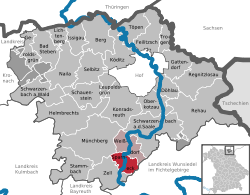
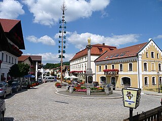
Zell im Fichtelgebirge, formerly Zell is a market town in the district of Hof in Bavaria in Germany.

Saal an der Saale is a municipality in the district of Rhön-Grabfeld in Bavaria in Germany. It is situated on the river Fränkische Saale. The municipality consists the two townships Saal an der Saale and Waltershausen.