The Thuringian Forest, is a mountain range in the southern parts of the German state of Thuringia, running northwest to southeast. Skirting from its southerly source in foothills to a gorge on its north-west side is the Werra valley. On the other side of the Forest is an upper outcrop of the North German Plain, the Thuringian Basin, which includes the city Erfurt. The south and south-east continuation of the range is the highland often called the Thuringian-Vogtlandian Slate Mountains.

The Saale, also known as the Saxon Saale and Thuringian Saale, is a river in Germany and a left-bank tributary of the Elbe. It is not to be confused with the smaller Franconian Saale, a right-bank tributary of the Main, or the Saale in Lower Saxony, a tributary of the Leine.

The Fichtel Mountains, form a small horseshoe-shaped mountain range in northeastern Bavaria, Germany. They extend from the valley of the Red Main River to the Czech border, a few foothills spilling over into the Czech Republic. They continue in a northeasterly direction as the Elster Mountains, and in a southeasterly direction as the Upper Palatine Forest. The Fichtel Mountains contain an important nature park, the Fichtel Mountain Nature Park, with an area of 1,020 square kilometres (390 sq mi).

The Bavarian Forest is a wooded, low-mountain region in Bavaria, Germany that is about 100 kilometres long. It runs along the Czech border and is continued on the Czech side by the Bohemian Forest. Most of the Bavarian Forest lies within the province of Lower Bavaria, but the northern part lies within Upper Palatinate. In the south it reaches the border with Upper Austria.
Hof is a Landkreis (district) in Bavaria, Germany. It is bounded by the districts of Wunsiedel, Bayreuth, Kulmbach and Kronach, the states of Thuringia and Saxony, and the Czech Republic. The city of Hof is an enclave within the district, as well as being the district's administrative seat.

The Franconian Forest, is a mid-altitude mountain range in Northern Bavaria, Germany. It is located in the district of Upper Franconia (Oberfranken) and forms the geological connection between the Fichtel Mountains and the Thuringian Forest. It is a broad well-wooded plateau, running for about 45 kilometres (28 mi) in a northwesterly direction, descending gently on the north and eastern sides towards the Saale river, but more precipitously to the Bavarian plain in the west, and attaining its highest elevation in the Döbraberg near Schwarzenbach am Wald. Along the centre lies the watershed between the basins of the Main and the Saale, belonging to the systems of the Rhine and Elbe respectively.

The Ochsenkopf Transmitter is a 163 metres (535 ft) radio and TV tower of reinforced concrete, which was built in 1958 on the summit of the 1,024 metres (3,360 ft) Ochsenkopf mountain, the second-highest mountain in the Fichtel Mountains in Northern Bavaria, Germany. The tower replaced a 50 metres (160 ft) guyed steel tube TV mast that collapsed in January 1958 as result of icing. The tower, which is not accessible to the public, has a hyperbolic-shaped basement with five floors for technical equipment. Above it, there are platforms for directional antennas. The antennas for FM-transmission are on the upper part of the concrete tower, those for TV transmission on a steel tube mast on the top.

Sparneck is a municipality in Upper Franconia in the district of Hof in Bavaria in Germany.

Zell im Fichtelgebirge, formerly Zell is a market town in the district of Hof in Bavaria in Germany.
The Kirchenlamitz–Weissenstadt railway was a German branch line in Bavaria. It was opened on 20 July 1899 as a Sekundärbahn by the Royal Bavarian State Railways.

The Fichtelgebirge Club is a large walking club and local heritage society in Bavaria and recognised conservation group with 20,000 members in 55 local groups. As the name says, its main sphere of activity is in the Fichtel Mountains in north Bavaria. Its emblem is the Arctic starflower.
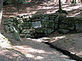
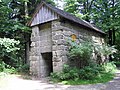
The Großer Waldstein is part of the Waldstein range in the Fichtel Mountains of Germany. It is known primarily for its rock formations caused by spheroidal weathering, its ruined castles and the only remaining bear trap (Bärenfang) in the region.
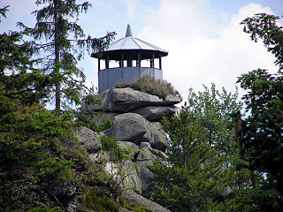
The Epprechtstein is a mountain in the northern Fichtel Mountains in northeast Bavaria, Germany, 798 m above sea level (NN). It is mineralogically the most interesting mountain in the entire Fichtel range. Around the summit there are about 20 quarries, in three of which Epprechtstein granite is quarried. The others are closed and partially overgrown.
The Königsheide is a high, forested ridge, made of gneiss-phyllite rock in the Fichtel Mountains in Bavaria, Germany. It is located to the southwest of the Ochsenkopf mountain. It is bordered to the east and south by the river of the Warme Steinach, and to the west by the Franconian Line. The villages of Warmensteinach and Weidenberg and the town of Goldkronach lie on the Königsheide.

The Höllpass is a 683 m high mountain pass in the northern part of the Fichtel Mountains in Bavaria, Germany.

The Jean-Paul-Weg is a 150 km hiking trail in Germany in honour of the writer Jean Paul Friedrich Richter (1763–1825), leading through the Franconian Forest, Fichtel Mountains, and Little Switzerland.
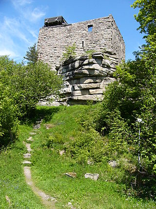
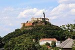
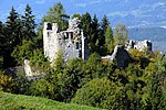
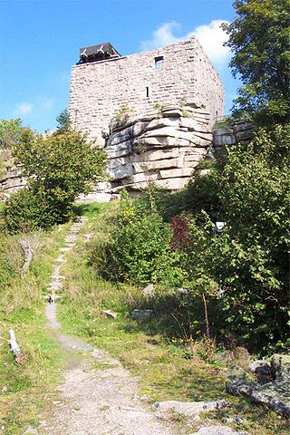
Epprechtstein Castle is a former hill castle on the mountain of the same name, the Epprechtstein, which rises above the village of Kirchenlamitz.

The Hoher Stein is a rock formation at the northeastern foot of the Bergkopf mountain, part of the Waldstein ridge in Germany's Fichtel Mountains.

The Bergkopf is an 857 metre high, thickly forested mountain in the Sparneck Forest in Germany's Fichtel Mountains.

The High Fichtel Mountains, or High Fichtel, form a mountainous and heavily forested range consisting of several mountain chains in the shape of a horseshoe, the Fichtel Mountain Horseshoe (Fichtelgebirgs-Hufeisen), that rings the Selb-Wunsiedel Plateau.